Shortcuts:
Main Tremor Index |
Interactive Tremor Map |
Realtime Tremor Map |
ETS diagnostic Spectrograms
|
Beginning in late February 2003, the PNSN started observing strange, long-lasting, weak signals on seismic stations in the north Puget Sound area. We believe that these are the same as or similar to the deep tremor observed in Japan by Obara. Because tremor had been primarily detected in volcanic areas, it is interesting that it has been observed in a non-volcanic region, likely associated with the subduction process. Seismic tremor has very different characteristics (e.g. smaller size, emergent onset) than tectonic earthquakes, making their detection by tectonic seismic triggering techniques extremely difficult. The PNSN has been developing techniques to detect these tremors for the past year.
This first real-time observation of a tremor episode by the PNSN began on February 26, 2003 and lasted until March 19th, when the bursts moved outside our network. During the same time period, a silent slip event occurred along the Cascadia Subduction zone. Other periods of tremor activity have been recorded on the PNSN in April, June, September and December of 2003, and in January of 2004. These subsequent periods of tremor are not associated with a recorded GPS slow slip event.
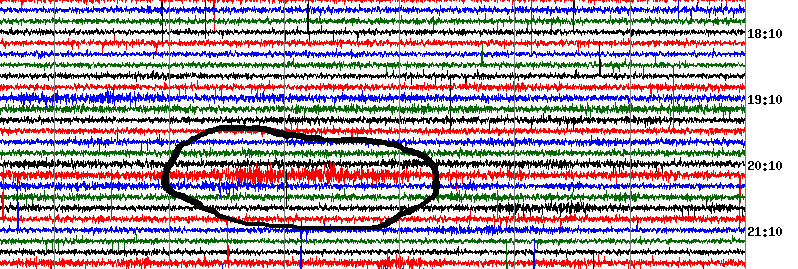
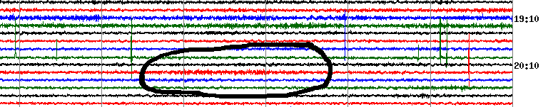
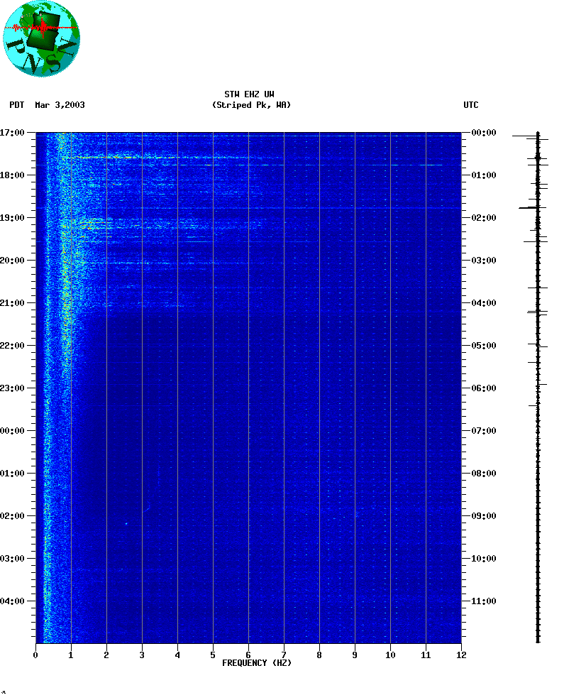
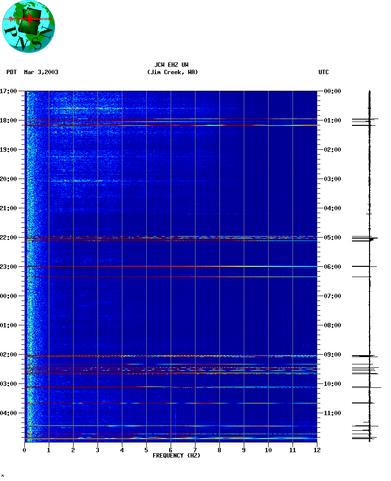
Below are two examples of an an early burst of deep tremor as recorded
on two stations in northern Puget sound (Feb 27, 2003).
Station STW on the north coast of the Olympic Peninsula (tremor burst is circled)
Station JCW in the north Cascades
Scientists at the Pacific Geoscience Center in British Columbia report observing the same signals in Feb-March 2003 on their stations and, in fact, have observed these sorts of tremors in previous years. They associate them both spacially and temporally with slow slip events as detected by the geodetic network. They produced a Press Release on their observations and interpretations on March 12, 2003. The PGC also provides a more detailed description of the geodetically observed slow slip events.
Characteristics of Deep Tremor Signals
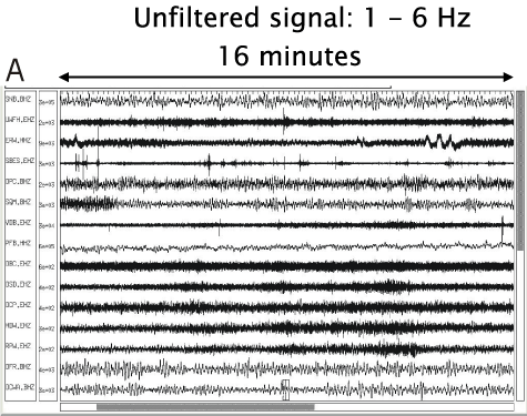
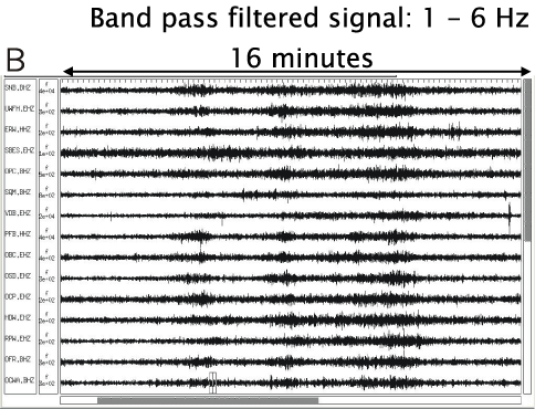
The Cascadia tremor signals have a frequency content between 1 and 6 Hz, and appear just above the noise on some stations without filtering, but on many more stations separated by hundreds of kilometers when the signals are band-pass filtered. The signals can contain single tremor bursts as well as a series of bursts and pulses over time periods lasting on the order of minutes to hours, and these bursts of activity persist from one week to a month.
Sample Spectrograms showing extended periods of tremor on Mar 3, 2003:
STW and
JCW
show semi-continous tremor between about 00:00 and 04:00 UTC
with stronger bursts
at about 00:35 and 03:05 UTC. Colorful lines going all across the frequency
bands are bursts of telemetry noise due to radio drop-out.
Network Analysis
On any individual station, the periods of tremor are usually very subtle.
Similar types of signals can also look like transient noises due to such things
as wind, vehicles, or other cultural activity near the station.
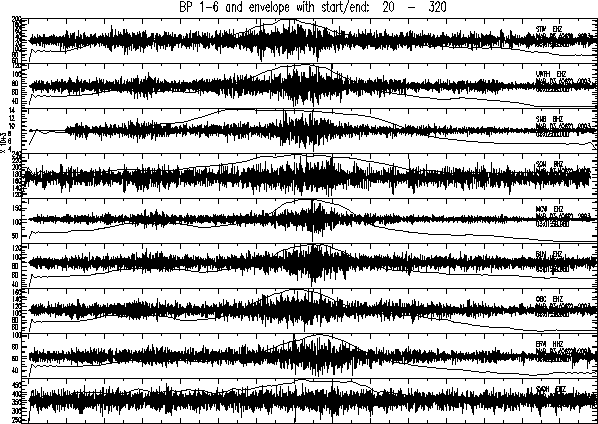
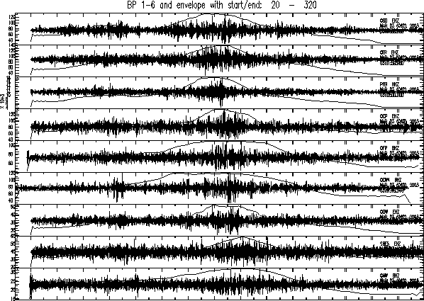
However, by combining information from several stations its possible to
eliminate local noise sources as the cause of the signals. A typical
processing technique is to strongly band-pass the signals for several stations
in the 1-6Hz band and then compute an envelope function by smoothing
and decimation. Plotting the filtered seismograms and the envelope together
makes it obvious that the period of increased tremor is common to many
stations at nearly the same time.
Five minute period starting about Mar 3 at 03:02 GMT
By correlating the envelope functions between stations it is possible to
get a relative delay time between them. When combining these for many
stations (up to 25 in some cases of strong signals) one can see a
progression from the early arriving stations to later ones which seem
to travel at S-wave velocities. One can then use a standard earthquake
location program with these apparent S-wave arrivals
to try and locate the source of these signals. Because the time
resolution of these relative times is poorly constrained, the accuracy of such
locations in not very good. Applying this method to a few
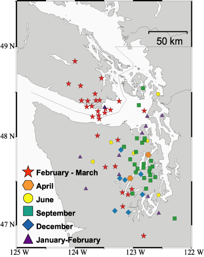
strong tremor periods produces locations in southern Vancouver Island
and the northern Olympic Peninsula. Depths are very difficult to constrain
but seem to be in the range of 20 to 40km deep.
The Next Step:
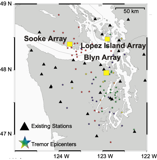
We continually process the PNSN data for more tremor periods to study how these sources may change over time. We have deployed three temporary seismic arrays, consisting of six 3-component seismographs, to determine the hypocentral locations and wave field characteristics of the next large sequence of tremor bursts. In order to narrow down the potential sources for the subduction tremor, we must be able to pinpoint the depth of the tremor bursts. Whether they occur at the plate interface, in the mantle wedge or at the base of the crust can lead to very different hypotheses about the source.
Seismic Array Locations
Epicentral Locations of Tremor Bursts
For more information contact: Wendy McCausland
wendy@ess.washington.edu
or Steve Malone steve@ess.washington.edu
Back to:...
UW Dept. of Earth and Space Sciences .....
PNW EARTHQUAKES