 ...... PNSN ETS HISTORICAL RECORD
Spring 2004 ETS
Deep Tremor in Cascadia Zone - Array Studies, 2004
PHOTOS:
Photo gallery of pictures
taken during the installation of the arrays.
Shortcuts:
Main Tremor Index |
Interactive Tremor Map |
Realtime Tremor Map |
ETS diagnostic Spectrograms |
PGC TAMS/SSA |
A heartfelt welcome and thanks to all of those who have contributed to the
Deep Tremor Array project! This page is dedicated to you, but is now available
to everyone so we we all can keep you updated on the latest tremor news.
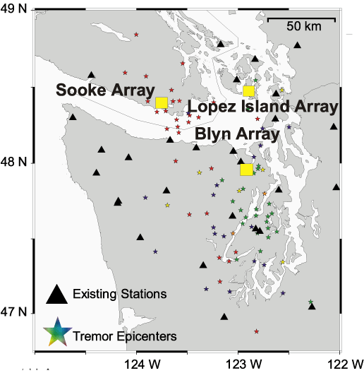
We installed all three arrays! Check out the array locations on the
overview map.
There are two stations with continuous online data
from Sooke, BC being recorded by the Pacific Geoscience Centre, here at PNSN
and the at the IRIS
PASSCAL instrument center.
Stations of the Lopez array can could be accessed remotely for near real-time
download of short segments of data. A number of data segments were retrieved
in near realtime which allowed us to find one case of a cut cable just at
the beginning of the ETS and get it fixed quickly.
NEWS (latest at the top)
- Aug 11, 2004 - The Sooke array was removed from the field and so the
array component of this study is finished. Data analysis has started but
will take some considerable time before significant results are ready.
This is the final near real-time report on this web page. When new bursts
of tremor are seen in Washington, Oregon or California, we will report on
those periods here or a similar but new page.
- Aug 7, 2004 - OK, it really is over now. The last of these "after bursts"
died out early on Aug 4 and nothing has been seen since then in Washington.
These tremor bursts between Aug 1 and Aug 4 were quite strong on a few stations
in central Puget Sound but weakly recorded at more distant stations.
The formal locations of a few of these bursts have shallow depths which
are consistent with the amplitude dsitribution.
At the other end of the subduction zone we have seen two small bursts
of tremor in northern California on August 2 with similar characteristics to
those in late May.
- Aug 2, 2004 - Wait a minute! Starting early on Aug 1, we see medium
strong tremor in the central Puget Sound area in bursts which cover most
hours of the past 30 hours. These are NOT being seen on the northern Puget
Sound stations, nor in southern Washington.
Our seismic arrays near Sequim and on Lopez Island were removed last
Tuesday and Thursday respectively. Data have been recovered during the tremor
period from these arrays and looks pretty good.
- July 26, 2004 - We are seeing almost no evidence of tremor on Washington
seismograph stations any more. Several days ago we could see tremor coming from
the northwest which was probably that reported by Garry Rogers as taking place
in south-central Vancouver Island. However, for the last couple of days we have
not seen that tremor either. We assume that this ETS is now over.
Our plan is to now start removing the special
small aperture arrays we installed to catch the tremor sequence. We know we
have good data on some of the array stations but for others we will need to
recover the stations, download the data and then do some conversions and
processing before we know how good the data are and how successful the arrays
were in providing a useful way to study the tremor.
- July 24, 2004 - MAIN ETS ENDS.
- July 20, 2004 - Over the past five days tremor has decreased in strength
and frequency in Washington. There have been some periods of tremor in
central Puget Sound, but most of what we are detecting is coming from the
north. The signal from this event on GPS instruments is obvious on many
GPS instruments in the northern Puget Sound and southern Vancouver Island.
Garry Rogers of the PGC reports today the following:
ETS tremor is observed in most
hours on Friday, Saturday, Sunday, Monday and today. Tremor is moving
north and it is mostly beneath southern Vancouver island now, VGZ is no
longer the strongest amplitude station.
It appears there is also a north Island ETS event going on at the same
time. There has been actvity in most hours since July 15 (starting
about 12 hrs before the Nootka fault earthquake). Herb has not yet
confirmed slip from GPS observations on north Island. It is sometimes
difficult to pick out amongst all the aftershocks, especially in the
hours immediatly following each of the two big Nootka fault events, but
it is migrating south from its initiation point just north of station
WOSB. It is now mostly in the vicnity of the projection of the Nootka
fault under Vancouver Island.
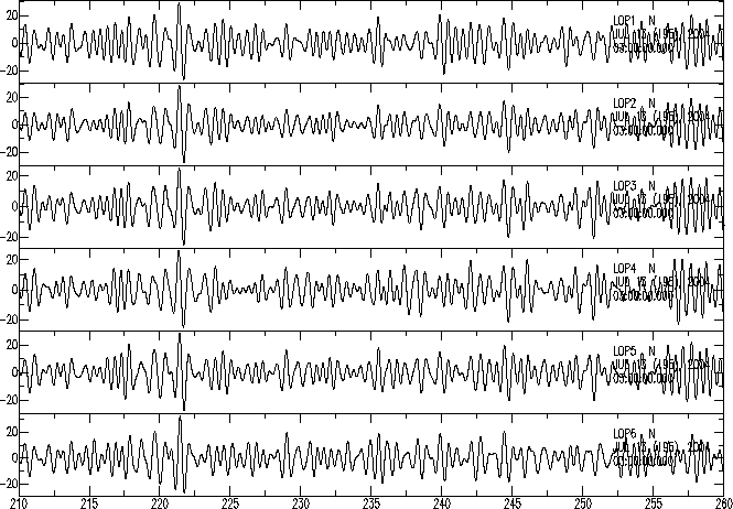
- July 15, 2004 - Tremor continues for the past two days with some periods
very strong. The variations of tremor strength on different stations makes
a confusing pattern indicating to us that there may be many different sources
sometimes going on at the same time. This is confirmed by some very
preliminary analysis of array data from Lopez Island. See
a sample of array waveforms for a
short segment of time band-passed filtered between 2.0 and 4.0 Hz.
Taimi Mulder of the
PGC reports that tremor seem to change character significantly on Vancouver
Island following the Mag=5.5 Nootka Island earthquake early this morning.
Possible changes at the same time in the Puget Sound are not obvious.
The geodetic analysis folks (Bill Sumner and Herb Dragert) are reporting
preliminary confirmation that a slip event is being seen on some
GPS instruments. It is not above the noise on enough instruments
to get a sense of the extent of the event yet
but seems confirm the event is under way.
- July 13, 2004 - Tremor on July 11 and 12 was almost continuous and quite
strong during several different periods. Preliminary locations put epicenters
just north of the Olympic Peninsula but there is some spread both to the
south and north. Preliminary plots of data from our Lopez Array shows very
good signal to noise for at least a few of the stronger tremor periods. As
of early on July 13 the tremor level seems to have decreased some and become
a bit less frequent.
The geodesists have been processing GPS data but report that
they see no evidence of the ETS yet.
- July 11, 2004 - THE ETS HAS STARTED!!!! There is no question now that
this is it. The tremor was fairly weak as of a couple of days ago, but as of
today we are seeing some very strong tremor. While we have not done any
formal locations, based on the strength of the tremor it would seem that
most of it is located in the north-east Olympic Peninsula area. It is strong
enough to record quite well over much of western Washington. Our three
seismic arrays are working well; however, one station in the Lopez array is down
because a haying machine distroyed the cable. We are replacing this cable
tomorrow and will check on the other arrays again soon thereafter.
- July 10 2004 - Tremor has increased over the past couple of days so
that it is both stronger and more often. We see it both on stations
in the north Puget Sound and also ones in the central Puget Sound. It
apears that the sources are both in the north and in the central area
at roughly the same time. This may be the ETS.
- July 9, 2004 - MAIN ETS BEGINS
- July 8, 2004 - Maybe some good news! Garry Rogers reported this morning
that there was weak tremor seen last night on some southern Vancouver Island
stations. We confirm that we see some of this on our northern Puget Sound
Stations and also see something again today around noon. This tremor is very
weak compared to what has been seen in the past, but it is in the right area
to be what we are looking for. Lets hope it continues and gets bigger.
- June 28, 2004 - Tremor in Washington has still not started. However,
Garry Rogers of the PGC reports the following:
Starting about 03:00UT until about 09:00UT Sunday, June 27, ETS was
observed with largest amplitudes on station MGB on southern Vancouver
Island. MGB is just south of Port Alberni.
Most hours in this time period contain a few minutes of tremor. One of
largest amplitudes is about 07:56UT. Most of this tremor is stronger
than was observed on June 16 with stronger bursts being observed to
distances greater than 100km. Weak tremor also observed in the same
region this morning (June 28) during hours, 13:00, 14:00 and 17:00 UT.
- June 16, 2004 -
While we are seeing no tremor in Washington or California for the past week
the following report is from Garry Rogers at the PGC;
Starting about 0300UT until about 1200UT June 16, weak ETS tremor was
observed with largest amplitudes on station MGB on southern Vancouver
Island. MGB is just south of Port Alberni. Most hours in this time
period contain a few minutes of tremor. One of largest amplitudes is
about 09:29. This is very weak tremor. No activity from 1200 to 2300.
- June 11, 2004 -
The California tremor bursts seem to have died out. For the first ten days
of June the northern California tremor bursts continued from time to time,
but at fairly weak levels and only for a few hours a day. From mid-day on
June 10 there have been no more tremor bursts in this area.
- June 7, 2004 -
Maybe the ETS is still to come. A report from Garry Rogers of the PGC (GSC)
this morning says:
"Starting at 2100 UT on June 6, short weak tremor sequences have been
occurring on southern Vancouver Island in most hours up to 1500UT June 7.
Strongest signals are on BTB, MGB and OZB, so source is in the region
of Port Alberni. Largest amplitudes are around 0815UT."
Also, the word from Herb Dragert is that, from a statistical perspective based
on previous ETS periods we might not expect the next one quite yet.
Also the PNSN saw a period of weak to medium level tremor in the south
central Puget Sound area on June 5 between 05:00 and 10:00 UT.
- June 4, 2004 -
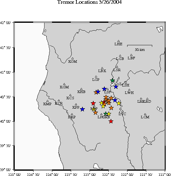
TWO NEW DEVELOPMENTS: 1. The deep tremor in the Pacific Northwest seems to
have died out completely. 2. We have found deep tremor in northern California.
After the southwestern Washington deep tremor became weak and seemed to move
into northwestern Oregon it became even weaker and died out with the last
period of obvious tremor being on the night of May 27. Nothing recognizable
as deep tremor has been seen since then. However, with prompting from
Seth Moran of the Cascade Volcano Observatory and the help of David Oppenheimer
of the Northern California Seismic Network we started examining data
from northern California and see deep tremor there. Starting weakly on about
May 23 with very strong bursts from time to time from May 25-29 we are still
seeing small to medium size bursts from time to time today. Some of the
stronger bursts could be located and are shown on a
map of northern California. The colors
are for events on different days (May 25,26-red, 27-yellow, 28-green,
29-blue). There is no reasonable depth control for these events yet.
- May 27, 2004 -
Low level of tremor contiunes for brief but detectable periods for the last
week, but seems to be even farther south. Poorly constrained locations put
some tremor bursts down near or just south of Portland, OR. No tremor is
seen north of southern Puget Sound. GPS processing by Dan Johnson seems
to indicate that the slip event seen in southern Washington terminated
around May 18.
- May 22, 2004 -
The tremor seems to have
almost completely stopped. There is no doubt that there was an ETS event
located in the south Puget Sound area centered around the time May 2-14
based on strong tremor and now the reported GPS (May 3-18, 2004)
measurements show a very significant event,.... but only in the south. Nothing
has moved to the north where our arrays are located.
We are waiting and waiting........
- May 17, 2004 - The deep tremor seems to be at MUCH lower levels for the
past 4 days. It may be spreading slightly north and south. There is some
indication that we are seeing it as far south as near Portland, OR. However,
it is so weak that it is difficult to see on more than a few stations
some of the time.
- May 15, 2004 - Over the past 36 hours the strong tremor has died out.
There are still weak periods of tremor in the south Sound area but not periods
of strong tremor anywhere.
- May 14, 2004 - Processing of GPS data (courtesy of Dan Johnson) shows geodetic changes at stations in southern Puget sound over the last few days.
See GPS measurements of 2004 tremor
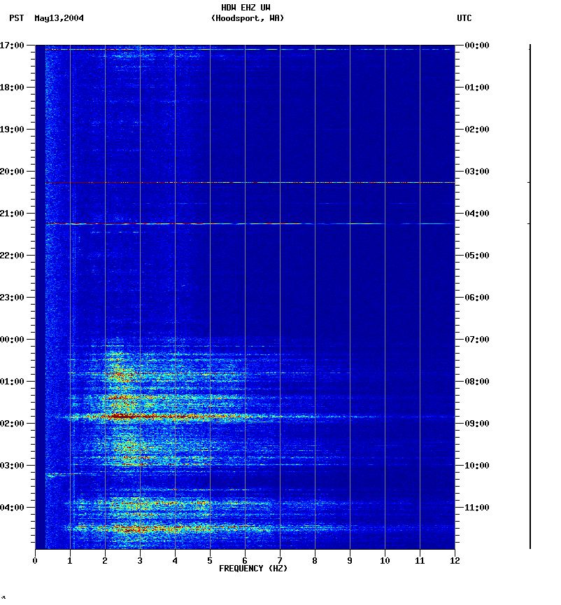
- May 13, 2004 - Tremor continues in south Puget Sound area but seems to have moved somewhat farther north over the past couple of days. Some particularly
strong tremor bursts can be weakly seen on sensitive stations in the north.
There is an
example spectrogram from a station in the west central Puget Sound (HDW)
for last night which shows a very strong tremor burst at about 01:50 PDT.
Telemetry connections have been established to four stations in the Lopez
array (Thanks Lopez School for the help!), and we can now down-load waveform
segments from these stations in near realtime, but are not trying to do
true real-time telemetry. Two stations from the Sooke array are being
telemetered to the PGC where they are recorded but not being
transfered to us yet.
- May 10, 2004 - I think we can say that the slip event has started!!
It is still concentrated in the southern Puget Sound, but there is
evidence that it is moving north. It is certainly getting stronger and
more near continuous and thus being recorded on stations in the central
and on quiet stations in the north. Thus far we don't think it would be
recorded on any of the array stations that are too far north.
Example Spectrograms from
earlier today illustrate how the tremor changes with time and that it
is strongest in the south Sound. Actually station HDW is very quiet and
sensitive so it exagerates the tremor strength there.
- May 7, 2004 -
Not much change in tremor today. There continue to be relatively small bursts
from time to time but only in the south-of-the-Sound area. Locations could
be determined for several burst and are shown on a
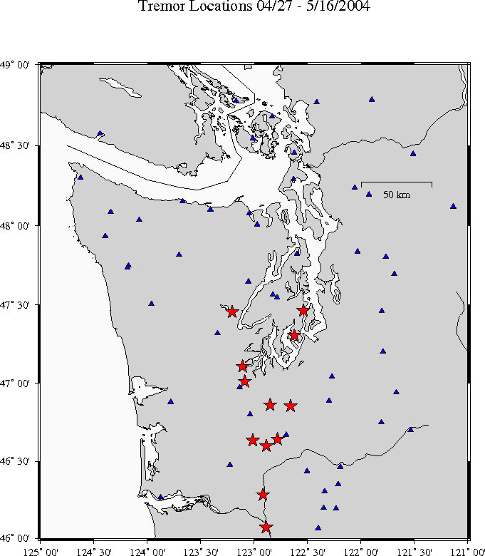
Tremor Burst Map as red stars. Blue triangles
are possible stations used for detecting and/or location.
- May 6, 2004 -
The burst of tremor south of Puget Sound are continuing off and
on over the past couple of days. There are periods of 6 or more
hours without
anything obvious and then there will be several hours with at least 10 minutes
of low-level tremor. This morning, May 6 at about 1405Z an extended period (~45min) of fairly strong tremor took place which was well recorded on all south
Sound stations and weakly at stations to the north and east.
Most tremor bursts are being seen only stations south
of the central Puget Sound.
- May 4, 2004 -
Again we have seen some bursts of deep tremor from the area south of Puget
Sound during May 3-4, but no bursts last more than 20-30 minutes and nothing
seems to be north of there. When is it going to really start?
- Apr. 27, 2004 -
A few short period of weak tremor were seen today on stations to the south
of Puget Sound. The location seems to be near Centralia. This is the first
time that deep tremor has been clearly seen south of Olympia.
- Apr. 20-27 -
Sooke array is installed. Equipment for this array is from the IRIS PASSCAL
instrument center and is capable of doing realtime telemetry from
Quanterra Q330 dataloggers using IP-radios
from remote field sites to a central receiving site and then onto the
Internet. Because the radios need line-of-site transmission (not even
trees in the way), our original plan and an alternate array configuration
were not appropriate. A great deal of effort was made by Tim Parker of the
instrument center to build, configure and install this array. Unfortunately
the real-time telemetry part of this array is possibly only working from
two of the stations which are connected via cable Internet from local houses.
- 12 April, 2004 -
Garry Rogers reports that there were periods of ETS tremor observed over several
different hours on Apr 10 and 11, but that nothing after that and so thinks
the BIG-ONE has not yet started.
- Apr 12-17 -
We are in Palm Springs for the annual meeting of the Seismological Society
of America and hoping that the BIG-ONE doesn't start before we can get back
and install the Sooke array.
- Mar. 22-23, 2004 -
Install Lopez array (6 stations) using three six componet
Lenartz M24 dataloggers and cables to a
remote station. These are locally recording dataloggers but have both a
serial and IP connectivity option. We are exploring options for
doing telemetry from the stations via digital radio to the Lopez School.
- Mar. 18-19, 2004 -
Install Sequim array using MarsLite instruments borrowed from Oservatorio
Vesuviano. Mario La Rocca from OV and Stefano Gresta from University of
Catania organize and assist with the installation.
- Nov. 2003 - Feb, 2004 -
Plans and siting visits at all three array sites. Instrumentation and
supplies organized.
- November, 2003 -
We hear from NSF that our proposal is funded to start in Jan. 2004.
- June, 2003 -
Proposal submitted to NSF to do an array study of deep tremor in Cascadia.
BACKGROUND INFORMATION
There has been information available on the web for the past year
about the deep tremor in 2003 as observed
by scientists at the UW and its
relationship to slow slip events and episodic tremor as detected by scientists at the
Pacific Geoscience Centre 2cof the Geological Survey of Canada.