| Magnitude | 3.3 |
|---|---|
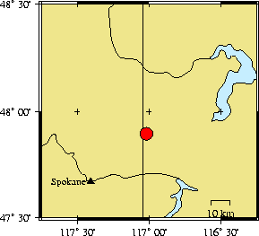
| Time | Monday September 22, 2003 at 14:06:19.97 Z (UTC) Monday September 22, 2003 at 07:06:19.97 AM (PDT) | Distance from | 38.7 km NE of Spokane, WA (Mission & N Division) 94.6 km WNW of Wallace, ID 97.6 km SE of Colville, WA |
| Coordinates | 47.897 deg N 117.017 deg W |
| Depth | 13 km |
| Quality | poor (AD) |
| Note: 1 km = 0.621 mile or 1 mile = 1.61 km | |