Beginning on September 21, a highly unusual sequence of earthquakes occurred near Klamath Falls, Oregon in an area which normally has no detectable seismicity. The 1993 Klamath Falls earthquake sequence includes two events (Me 5.9 and 6.0) on September 21 that are among the largest earthquakes to have occurred in Oregon in this century (the felt area of the 1936 Oregon/Washington border earthquake was larger). This sequence included a felt foreshock. the two mainshocks, and many aftershocks. The initial foreshock, Mc=3.9, was felt in the Klamath Falls area at 03:16:55 GMT; followed twelve minutes later by the Me 5.9 earthquake at 03:28:55 GMT. Sixteen aftershocks in the Me 2.4-3.8 range (including two felt Me 3.8 earthquakes at 04:16 and 04:34 GMT) were then recorded prior to the second mainshock (Me 6.0) at 15:45 GMT. A total of 106 earthquakes I. 7 and larger located in the area by the end of September, and aftershock activity continued in October. A preliminary report on this sequence was published in Oregon Geology (Wiley et al., 1993).
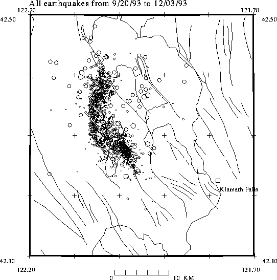
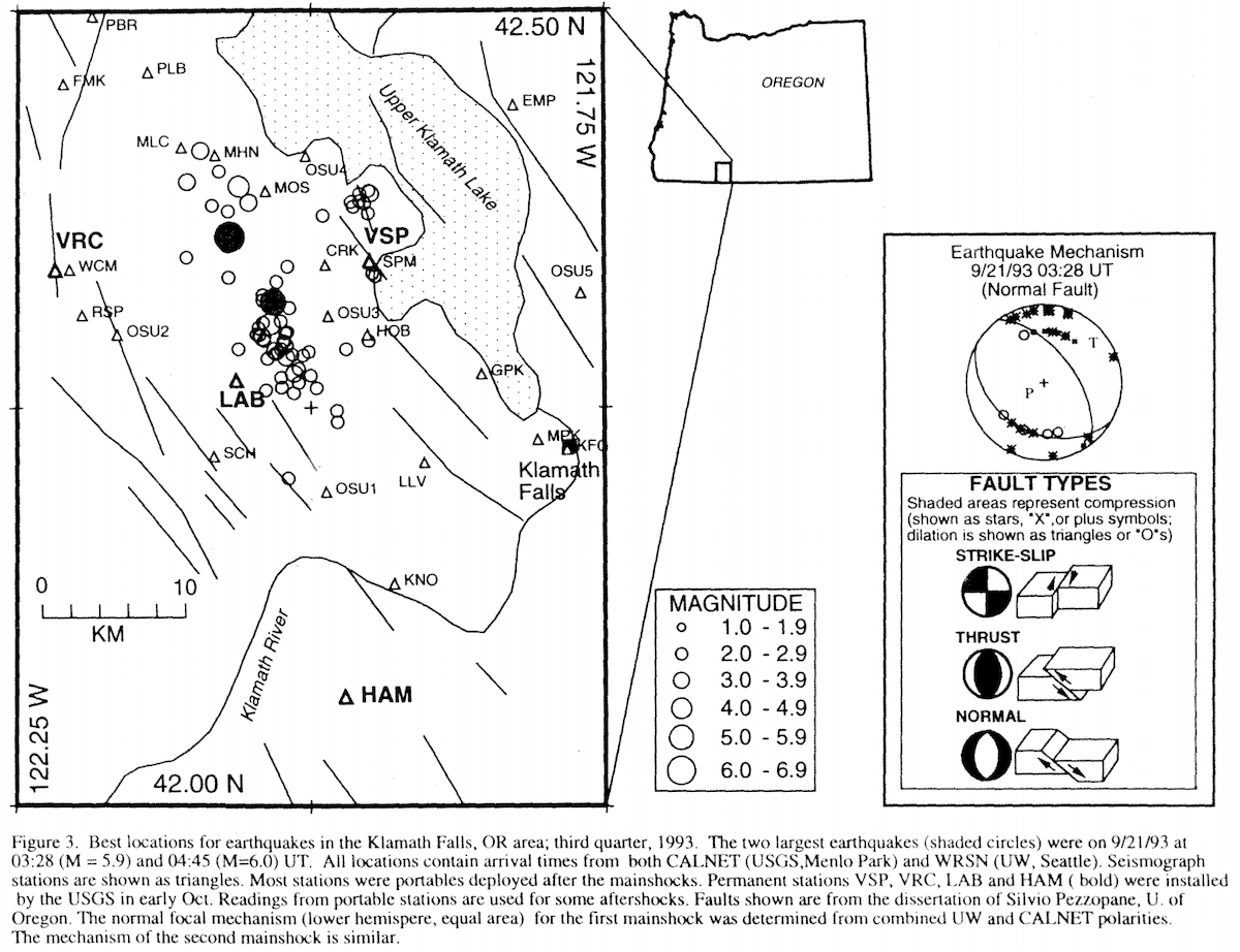
Figure 3 is an epiccntral plot showing the best-located earthquakes in the Klamath Falls area. Because the Klamath Falls area lies between the areas covered by the WRSN and CALNET, A.I. Qamar (UW) and K. Meagher (USGS) have recomputed locations by combining WRSN and CALNET data and using data from portable instruments placed in the epicentral region the day after the main shock. They used a velocity model based on the Modoc Plateau (Zucca et al., 1986, JGR. V. 9. pp. 7359-7382). Station corrections were determined using travel-time residuals from three well-located aftershocks for which arrival-time readings were available from close-in portable stations.
The earthquake hypocenters occurred in several groups that were initially isolated from one another. For example, the Me 6.0 earthquake occurred in a cluster 5 km northwest of the cluster that included the earlier Me 5.9 earthquake. Fault plane solutions indicate that both main shocks were normal faulting on north to northwest trending faults: one interpretation is that both earthquakes lie on different segments of the same fault zone. Two days after the main shocks another fault zone became active near the western shore of Klamath Lake in an area that is 8 km east of the primary fault zone. Unlike the primary fault zone vhich had earthquakes with foci up to 12 km deep, the earthquakes along the western shore of Klamath Lake were very shallow.
Geologically, the Klamath Falls area lies at the westernmost extent of the Basin and Range geomorphic province, and the current activity is along the western margin of the Klamath Graben; in a down-dropped area bounded by normal faults. Focal mechanisms of both main shocks correspond to normal faulting along northwest striking faults. In 1968 another basin and range sequence occurred in southern Oregon in the Warner Valley near Adel, OR. Reports from geologists who examined the Klamath Falls area after the earthquakew indicate that although cracking due to settling of unconsolidated material was observed, no evidence of primary ground rupture was found.
Two deaths, one due to a rockfall triggered by the earthquake and another from a heart attack were attributed to the earthquakes. Damage was severe in the Klamath County Courthouse, a hybrid building with several additions. Other notable damage included cracking of a highway bridge over a canal on state Rt. 140 (probably due to settling), broken or cracked parapets in brick buildings, fourteen broken display windows at "Yesterday Plaza" antique mall and damage to the Oregon Institute of Technology student union building (a modern building with an eccentric floor plan). Many homes were also damaged, particularly masonry chimneys and veneer. This earthquake was located in a rural area where historic seismic activity was unknown. Based on geologic simalarity to area to the east and south where seismic activity has occurred, Klamath County was in the very early stages of developing emergency plans for earthquakes. Plans for rural areas must concider problems such as dispersed populations, sparse emergency resources and a lack of trained personnel to conduct building inspections. Aftershock activity has continued into October.
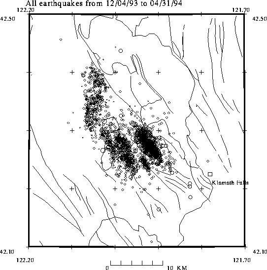
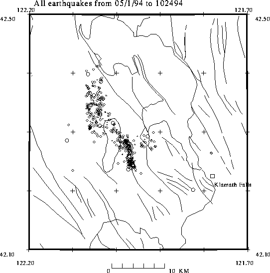
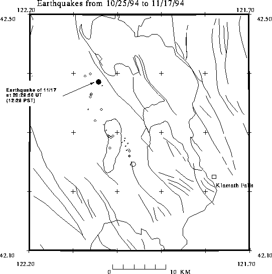
of Klamath Falls earthquakes.