Information contained in this report is preliminary,
and should not be cited for publication.
Seismograph network operation in Washington and Oregon is supported by the state of Washington and the following contracts: U.S. Geological Survey Joint Operating Agreement 1434-HQ-98-AG-01937 and Contract 259116-A-B3 from the Pacific Northwest National Laboratory, operated by Battelle for the U.S. Dept. of Energy
Felt Earthquakes during the 3rd Quarter of 1999
  DATE-(UTC)-TIME   LAT(N) LON(W)  DEPTH   MAG  COMMENTS
  yy/mm/dd hh:mm:ss   deg.   deg.    km
99/07/02 05:22:19  47.36N 122.39W  27.1    3.1  14.9 km   N of Tacoma, WA
99/07/03 01:43:54  47.07N 123.46W  40.7    5.1  8.0 km   N of Satsop, WA
99/07/09 07:45:42  47.06N 123.46W  39.8    2.1  6.8 km   N of Satsop, WA
99/07/16 05:58:24  45.65N 122.77W  19.7    2.3  17.7 km  NW of Portland, OR
99/07/16 05:59:59  45.65N 122.77W  18.9    2.3  17.7 km  NW of Portland, OR
99/07/16 21:34:03  45.64N 122.76W  18.1    3.1  17.2 km  NW of Portland, OR
99/08/25 17:48:43  47.75N 121.86W   7.4    2.0  9.5 km ENE of Duvall, WA
99/09/03 07:16:18  47.50N 123.12W   0.0    2.9  38.2 km   W of Bremerton, WA
99/09/05 18:01:36  47.16N 123.12W  46.5    2.8  22.3 km  NW of Olympia, WA
99/09/20 11:16:54  47.60N 121.76W  16.9    2.8  10.4 km ENE of Fall City, WA
There were 1661 events digitally recorded and processed at the University of Washington between July 1 and Sept. 30, 1999. Locations in Washington, Oregon, or southernmost British Columbia were determined for 592 of these events; 505 were classified as earthquakes and 87 as known or suspected blasts. The remaining 1069 processed events include teleseisms (161 events), regional events outside the PNSN (85), and unlocated events within the PNSN. Unlocated events within the PNSN include very small earthquakes and some known blasts. Frequent mining blasts occur near Centralia, Washington and we routinely locate and retrieve broad-band data for some of them.
On July 16 (UTC) three earthquakes were felt in the Portland area. Two magnitude 2.3 earthquakes within less than two minutes were followed by a magnitude 3.1 quake in the same location about 16 hours later. The focal mechanism suggests oblique strike-slip movement on a NNW or ENE striking fault.
In the Klamath Falls area, 13 earthquakes were located this quarter. Most earthquakes northwest of Klamath Falls are aftershocks of a pair of damaging earthquakes in September of \fI1993\fR (Sept. 21, 03:29 and 05:45 UTC; magnitudes 5.9 and 6.0 respectively). These earthquakes were followed by a vigorous aftershock sequence which has decreased over time.
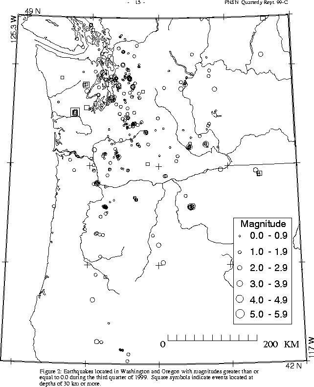
During the third quarter of 1999, 391 earthquakes were located between
45.5°-49.5° north latitude and
121°-125.3° west longitude, including the largest Benioff zone
earthquake since 1965.
Magnitude estimates for this earthquake varied considerably. The coda magnitude scale used by the PNSN has not been well calibrated for large and deep earthquakes in the Pacific Northwest since they occur so infrequently. The National Earthquake Information Center (NEIC) has assigned this earthquake a magnitude of 5.5 based on the body wave scale and the surface wave scale. NEIC gives a moment magnitude of 5.9 for this event.
The hypocentral depth indicates that this event is a Benioff Zone earthquake, occurring in the subducted Juan de Fuca plate. The PNSN's P-wave first-motion focal mechanism for this event is consistent with the moment-tensor focal mechanism determined by Oregon State University, and indicates normal faulting with a nearly horizontal T axis. No aftershocks were recorded immediately following the event but on July 9 there were 3 small earthquakes with similar hypocentral coordinates occurring at 05:13UT (Mag 1.5), 07:45UT (Mag 2.3), and 08:07UT (Mag 2.3 - reported felt). Another aftershock occurred on August 11 at 17:37 UT (Mag 1.7). Both the focal mechanism and lack of sizable aftershocks are typical of Benioff Zone earthquakes.
The July 3 UTC earthquake was felt throughout most of western Washington and
northwest Oregon, and in parts of southwest British Columbia, Canada.
The strongest shaking corresponded to a level of about VI on the Modified
Mercalli Intensity scale. Structural damage included cracked
chimneys and broken windows. The three-story Grays Harbor County Courthouse,
built in 1910 and located in Montesano, suffered extensive structural damage to its cupola. Interior walls wer
e also cracked. The Montesano fire station, built around 1979, also suffered structural damage.
oriented east-west. In Aberdeen, some structural cracks of walls and beams
were reported. In addition, power outages and water main breaks occurred.
The wood-framed roof of a furniture store collapsed. An engineering firm, EQE,
has provided a summary of damage information at:
.ce 1
Ground motions from this earthquake were recorded by 11 PNSN strong motion stations. Peak accelerations and a list of the PNSN stations is available at:
Other earthquakes in western Washington this quarter
This quarter, the deepest event recorded by the PNSN was a magnitude 1.3 earthquake at about 96 km depth. It occurred on September 10 at 02:04 UTC, about 13.5 km NNW of Hyak, WA. This location is in the area where such deep events are most frequently located.
On July 2 (UTC), a magnitude 3.1 earthquake 15 km north of Tacoma was widely felt in the Puget Basin. Four other small earthquakes were felt in western Washington this quarter. >
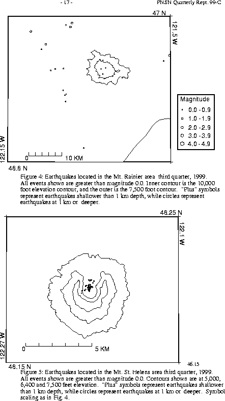
A total of 33 tectonic events (14 of these were smaller than magnitude 0.0, and thus are not shown in Fig. 4) were located within the region shown in Fig. 4. Of these, 19 were located in the "Western Rainier Seismic Zone" (WRSZ), a north-south trending lineation of seismicity approximately 15 km west of the summit of Mt. Rainier (for counting purposes, the western zone is defined as 46.6-47 degrees north latitude and 121.83-122 west longitude). The largest tectonic earthquakes near Mt. Rainier this quarter was magnitude 1.7.
This quarter, there were 8 higher-frequency tectonic-style earthquake within 5 km of the summit. The remaining events were scattered around the cone of Rainier as seen in Fig. 4.
Two type "S" or "L" event was located at Mount St. Helens, and 409 "S" events too small to locate were recorded.
During the third quarter of 1999, 55 earthquakes were located in eastern Washington in the area described in Table 4A. The largest earthquakes were on Sept. 19; at 04:21 UTC and 11:11 UTC; magnitudes 3.1 and 3.2 respectively. Both were at depths of more than 12 km; quite deep for this area. The earlier event was located about 28 km NNE of Prosser, and the late r about 33 km NW of Prosser. Neither event was reported to have been felt.