Information contained in this report is preliminary,
and should not be cited for publication.
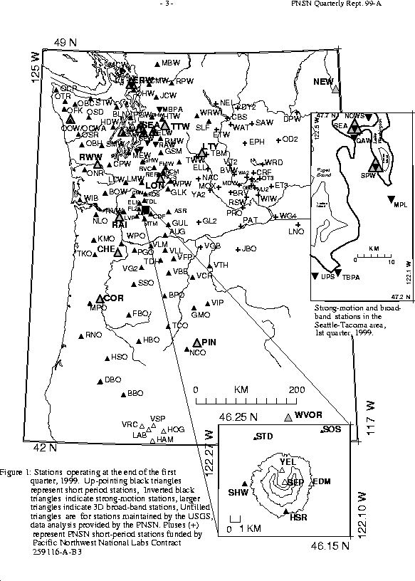
Seismograph network operation in Washington and Oregon is supported by the state of Washington and the following contracts: U.S. Geological Survey Joint Operating Agreement 1434-HQ-98-AG-01937 and Contract 259116-A-B3 from the Pacific Northwest National Laboratory, operated by Battelle for the U.S. Dept. of Energy
Felt Earthquakes during the 1st Quarter of 1999
  DATE-(UTC)-TIME   LAT(N) LON(W)  DEPTH   MAG  COMMENTS
  yy/mm/dd hh:mm:ss   deg.   deg.    km
99/01/04 15:10:37  47.20N  122.26W   22.2  3.2   12.5 km ESE of Tacoma, WA
99/01/11 13:48:46  45.31N  121.65W    7.5  2.5   6.5 km SSE of Mount Hood, OR
99/01/11 16:54:11  45.31N  121.65W    7.0  3.0   6.6 km SSE of Mount Hood, OR
99/01/11 22:04:14  45.31N  121.65W    6.9  3.2   7.0 km SSE of Mount Hood, OR
99/01/14 11:56:47  45.31N  121.66W    7.6  3.2   5.4 km SSE of Mount Hood, OR
99/01/14 16:13:42  45.31N  121.65W    5.9  3.0   6.2 km SSE of Mount Hood, OR
99/01/31 11:33:32  42.76N  124.68W   25.0  2.6   76.4 km SSW of Coos Bay, OR
99/02/24 16:45:17  45.11N  122.66W   35.7  2.7   14.6 km  S of Canby, OR
99/03/16 13:39:49  48.48N  121.80W    0.0  1.8   7.3 km  SW of Concrete, WA
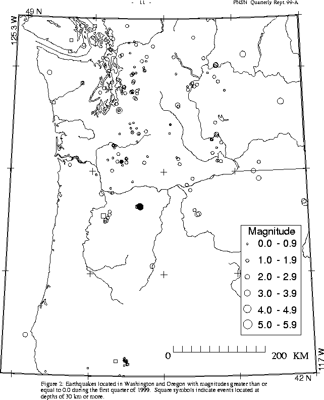
There were 757 events digitally recorded and processed at the University of Washington between January 1 and March 31, 1999. Locations in Washington, Oregon, or southernmost British Columbia were determined for 474 of these events; 449 were classified as earthquakes and 25 as known or suspected blasts. The remaining 283 processed events include teleseisms (104 events), regional events outside the PNSN (61), and unlocated events within the PNSN. Unlocated events within the PNSN include very small earthquakes and some known blasts. Frequent mining blasts occur near Centralia, Washington and we routinely locate and retrieve broad-band data for some of them.
Mt. Hood Earthquake Swarm: earthquake swarm occurred near Mt. Hood this quarter. Beginning on Jan. 11, the swarm continued vigorously through Jan. 15, including a total of 81 located events, 7 larger than magnitude 2.0. The largest event was magnitude 3.2. Most events were at depths of 4-7 km. The first-arrival focal mechanism for the largest earthquake indicates normal motion on a NW striking fault. Five of the largest events were reported felt at Timberline, Brightwood, Parkdale, and Mount Hood Meadows. Location details are given in Table 4. The Seattle USGS Office installed several portable digital seismic recording instruments during the weekend of Jan. 16-17, just after the end of the vigorous activity, and removed them about two weeks later without recording much useful data. Activity continued at a lower level through the end of the quarter - 34 additional earthquakes were located in the same area, including one larger than magnitude 2.0; a M 2.6 on Feb. 15 at 15:37 UTC.
Since 1990, Mount Hood has produced about 15 earthquake swarms similar to this quarter's. These swarms have lasted from a few hours to several days, have produced from several to tens of well-located earthquakes, have been clustered between 4 and 7 km (2.5-5 miles) south of the volcano's summit, and have generally produced maximum magnitudes between 1.6 and 3.5. Seismic data of lower quality indicate that swarms also occurred in the 1970s and 1980s. The largest recorded earthquake at Mount Hood was a magnitude 4.0 in December 1974.
All of the earthquakes in the Mount Hood swarms have characteristics similar to tectonic earthquakes rather than volcanic earthquakes (indicative of magma movement). The recent Mount Hood earthquakes most likely result from regional tectonic stresses, although they may also be caused by deep seated changes in the volcano's plumbing system.
Maps and and general information about Mount Hood may be found on the WORLD WIDE WEB at URL:
http://vulcan.wr.usgs.gov/Volcanoes/Hood/framework.html
Information about seismic activity near Mount Hood may be found at:
/SEIS/PNSN/HOOD
A magnitude 2.7 earthquake on Feb. 24, 1999 was rather widely felt in northern Oregon, with reports from Salem, Portland, Oregon City, Washougal and Vancouver WA. The unusual depth of this earthquake (35 km) may account for the large felt area. Although this event was located in the general vicinity of the 1993 Magnitude 5.6 Scott's Mills earthquake, the much greater depth of the Feb. 24 event suggests that it is unrelated to the Scott's Mills activity. Details on the earthquake location are included in Table 4.
In the Klamath Falls area, 21 earthquakes were located this quarter. Most earthquakes northwest of Klamath Falls are aftershocks of a pair of damaging earthquakes in September of \fI1993\fR (Sept. 21, 03:29 and 05:45 UTC; @ M sub c @ 5.9 and 6.0 respectively). These earthquakes were followed by a vigorous aftershock sequence which has decreased over time.
During the first quarter of 1998, 248 earthquakes were located between 45.5°-49.5° north latitude and 121°-125.3° west longitude.
This quarter, the deepest events recorded by the PNSN were not in Washington, but north of the border in British Columbia beneath Vancouver Island. A magnitude 1.7 earthquake occurred at a depth of about 53 km on March 5 at 02:36 UTC, and a magnitude 1.9 quake at a depth of about 54 km on March 21 at 19:29 UTC.
The largest earthquake in Washington this quarter was the magnitude 3.2
earthquake on Jan. 4 (see Table 4). One other earthquake was reported
felt in western Washington this quarter. Details are provided in Table 4.
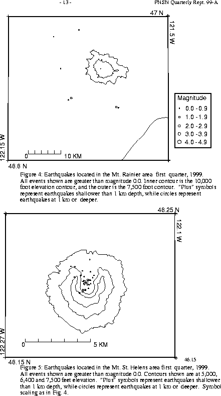
Figure 4 shows earthquakes near Mount Rainier. The number of events in close proximity to the cone of Mt. Rainier varies over the course of the year, since the source of much of the shallow surface-type activity is presumably ice movement or avalanching, which is seasonal in nature. Events with very low frequency signals (1-3 Hz) believed to be icequakes are assigned type "L" in the catalog. Emergent, very long duration signals, probably due to rockfalls or avalanches, are assigned type "S" (see Key to Earthquake Catalog). "L" and "S" type events are listed in the catalog, but not shown in Figure 4. Although no events flagged "L" or "S" events were located at Rainier this quarter, 7 "L" or "S" events there were too small to locate.
A total of 16 events (7 were smaller than magnitude 0.0, and thus are not shown in Fig. 4) were located within the region shown in Fig. 4. Of these, 12 were located in the "Western Rainier Seismic Zone" (WRSZ), a north-south trending lineation of seismicity approximately 15 km west of the summit of Mt. Rainier (for counting purposes, the western zone is defined as 46.6-47 degrees north latitude and 121.83-122 west longitude). The largest tectonic earthquake this quarter was magnitude 1.8.
Although no type "S" or "L" events were located at Mount St. Helens, 26 "S" events too small to locate were recorded.
During the first quarter of 1999, 49 earthquakes were located in eastern Washington in the area described in Table 4A. The largest two earthquakes recorded this quarter in eastern Washington were magnitude 3.1, and both had somewhat unusual locations. The first, on Jan. 31 at 11:05 UTC was located at 10 km depth about 44 km NNE of Grand Coulee. The second, on March 12 at 13:05 UTC was located at 6 km depth about 42 km SSW of Spokane. No foreshocks or aftershocks were recorded, and neither earthquake was reported felt to the PNSN.
Times, locations, and depths of felt earthquakes in the PNSN region are given in Table 4. Table 4A is a summary table of various earthquake counts-per-quarter over several years.