Analysis of Crustal Deformation in Western Washington using GPS
USGS Grant No. 99HQGR0064
A.I. Qamar, P.I.
Dept. of Earth and Space Sciences, Box 351310, University of Washington,
Seattle, WA 98195-1650
Phone:(206)543-8020 FAX:(206)543-0489
e-mail: tony@geophys.washington.edu
URL: http://www.geophys.washington.edu/GPS/
Program element: II, (Research on Earthquake Occurrence and Effects)
Key words: GPS-Campaign, Strain Measurements
Investigations
This report covers the period April 1, 1999 to October 31, 1999. The purpose of this study is to collect new GPS data at temporary sites in Washington and to analyze the GPS data at these sites together with data collected at the same sites in previous years by various institutions including the University of Washington, US Geological Survey, and National Geodetic Survey. Our goal is to determine deformation rates in the earth's crust including strain orientation and its partitioning among the different tectonic structures of western Washington, particularly in the Puget Sound Region.
By comparing the deformation to physical models we will gain a better understanding of the processes that produce damaging earthquakes in the Pacific Northwest. This study complements analysis of GPS data from permanent, continuously operating GPS trackers in the Pacific Northwest (Pacific Northwest Geodetic Array or PANGA). Preliminary results from the PANGA array have been published by Khazaradze, Qamar, and Dragert, 1999.
Results
Analysis of the campaign data is in a preliminary stage. We have collected data from previous campaign surveys by UW, the US Geological Survey and and the National Geodetic Survey (in particular the extensive survey done in 1998 of HARN sites in Washington and Oregon). Ronnie Ning, a new graduate student at UW is now comparing different analysis procedures of the GPS data using JPL GIPSY software.
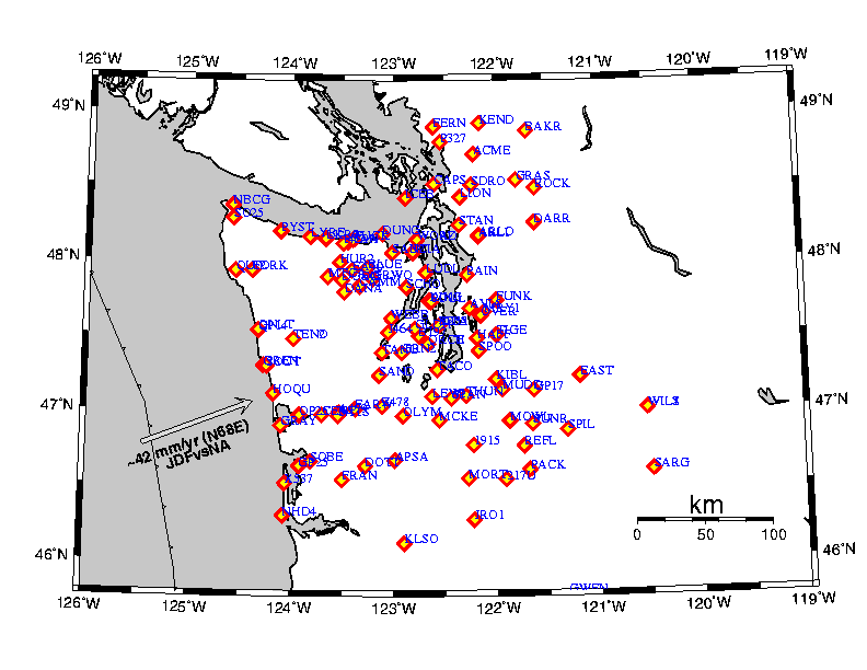
Preliminary analysis of some of the older campaign data has been reviewed by Khazaradze, 1999. The figure below shows campaign sites that we have
previously analyzed. Selected sites from the ones shown will be reoccupied in the summer of 2000 in a joint survey with Rob McCaffrey at RPI and Chris Goldfinger at Oregon State with support by NSF/UNAVCO. Since much earlier occupations of sites shown in the figure, the National Geodetic Survey together with a number of private and public agency volunteers collected data from a couple of hundred sites in August-November, 1998 (UW collected data at six sites). A number of these sites had been previously occupied by the USGS and UW. In 2000 we plan to collect data at 30 to 40 of the sites shown in the figure. Sites at similar station-spacing will be occupied in Oregon by RPI/Oregon State. The campaign data will be complemented by data collected daily by PANGA. It should be noted that these continuous data are available online at http://www.geophys.washington.edu/GPS/ and the PANGA data processing center at http://panga.cwu.edu or at the Scripps Orbit and Permanent Array Center (SOPAC) http://lox.ucsd.edu.
Non-technical Summary
Analysis of GPS data from a number of temporary sites in Washington will permit us to monitor deformation at much better spatial resolution than is possible with existing continuous stations in the Pacific Northwest Geodetic Array (PANGA). Station velocities determined from campaign measurements the UW has collected so far are in general agreement with continuous station measurements but some sites show anomalous velocities that need to be confirmed with further campaign data collection in 2000.
For further information on GPS work at UW see http://www.geophys.washington.edu/GPS/.
Reports
Khazaradze, G; Qamar, A; Dragert, H., 1999, Tectonic Deformation in Western Washington from Continuous GPS Measurements, Geophysical Res. Lett., v. 26, p. 3153-3156.
Khazaradze, G, 1999, Tectectonic Deformatuon in Western Washington State from Global Positioning System Measurements, PhD Thesis, Dept. of Earth and Space Sciences, University of Washington, Seattle, 165 pages.