Information contained in this report is preliminary,
and should not be cited for publication.
Seismograph network operation in Washington and Oregon is supported by the state of Washington and the following contracts: U.S. Geological Survey Joint Operating Agreement 1434-HQ-98-AG-01937 and Contract 259116-A-B3 from the Pacific Northwest National Laboratory, operated by Battelle for the U.S. Dept. of Energy
Felt Earthquakes during the 1st Quarter of 1998
  DATE-(UTC)-TIME    LAT(N) LON(W) DEPTH MAG COMMENTS
  yy/mm/dd hh:mm:ss   deg.   deg.    km
_
1. 98/01/22 23:37:03  47.18N 121.93W 16.5 2.0  3.1 km ESE of Enumclaw, WA
2. 98/02/15 15:14:53  46.85N 121.96W  9.3 3.2 16.2 km   W of Mount Rainier
3. 98/03/03 04:19:02  49.15N 118.35W  0.6 4.0 76.4 km NNW of Colville, WA
There were 1,132 events digitally recorded and processed at the University of Washington between January 1 and March 31, 1998. Locations in Washington, Oregon, or southernmost British Columbia were determined for 692 of these events; 639 were classified as earthquakes and 53 as known or suspected blasts. The remaining 440 processed events include teleseisms (109 events), regional events outside the PNSN (64), and unlocated events within the PNSN. Unlocated events within the PNSN include very small earthquakes and some known blasts. Frequent mining blasts occur near Centralia, and we routinely locate and retrieve broad-band data for some of them.
Beginning at 1200 GMT on 25 January 1998,
the National Oceanographic and Atmospheric Administration (NOAA),
using the U.S. Navy's SOund SUrveillance System (SOSUS);
detected intense seismicity on the summit and southern flank
of Axial Seamount on the central Juan de Fuca Ridge near 45.9 degrees
north latitude and 130 degrees west longitude;
approximately 300 miles west of Cannon Beach, Oregon.
Seismicity included thousands of earthquakes, including 3
of magnitude 4.5 or larger. Seismic activity dropped to background levels
by early February. See web page:
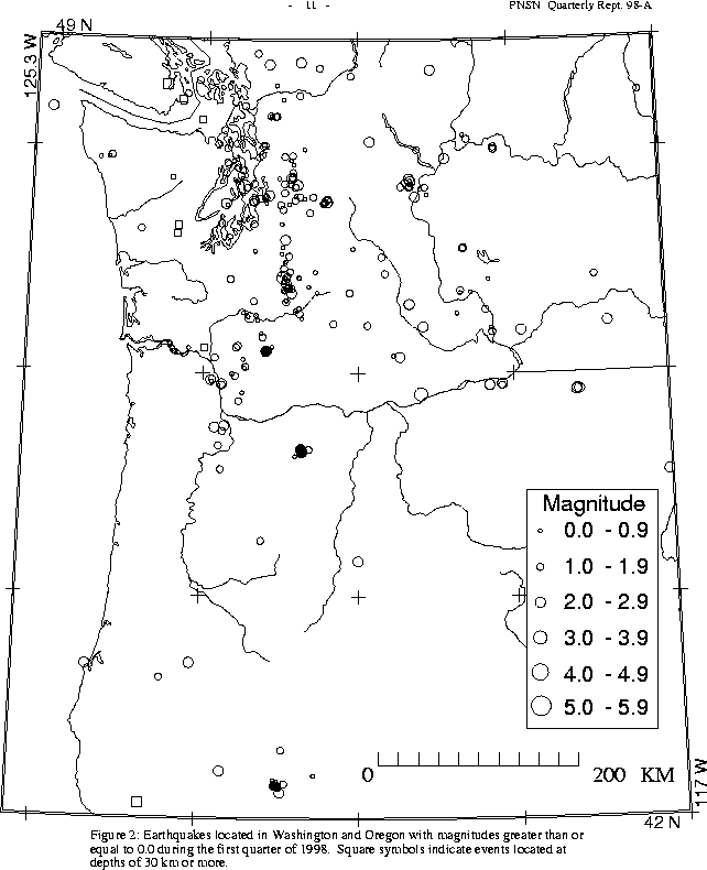
A magnitude 5.1 earthquake at 43.44N, 127.10W (NEIC location and magnitude) occurred on March 23 at 02:28 UTC near the south-eastern end of the Blanco Fracture Zone.
In the the Klamath Falls area, 32 earthquakes (4 of magnitude 1.6 or larger) were located this quarter. Most earthquakes in the Klamath Falls are are aftershocks of a pair of damaging earthquakes in September of 1993 (Sept. 21, 03:29 and 05:45 UTC; Mc 5.9 and 6.0 respectively) were followed by a vigorous aftershock sequence which has decreased over time.
During the first quarter of 1998, 476 earthquakes were located between 45.5° and 49.5° north latitude and between 121° and 125.3° west longitude. This quarter, one event in western Washington was deeper than 50 km. It occurred at on Jan. 22 at 17:19 UTC a depth of about 52 km had a magnitude of 0.9, and was located near Tacoma.
Two small earthquakes were reported felt in western Washington this quarter, one
near Enumclaw, and the
other in the Western Rainier Seismic Zone (WRSZ).
Time, location, and depth details are given in Table 4.
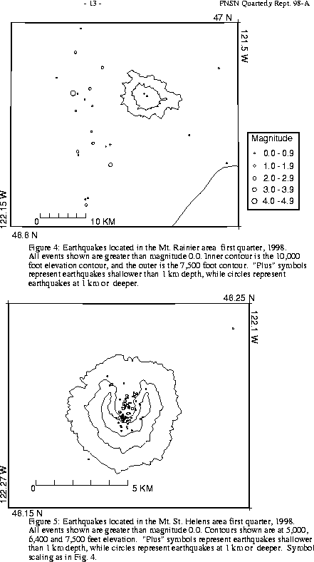
Figure 4 shows earthquakes near Mount Rainier. The number of events in close proximity to the cone of Mt. Rainier varies over the course of the year, since the source of much of the shallow surface-type activity is presumably ice movement or avalanching, which is seasonal in nature. Events with very low frequency signals (1-3 Hz) believed to be icequakes are assigned type "L" in the catalog. Emergent, very long duration signals probably due to rockfalls or avalanches are assigned type "S" (see Key to Earthquake Catalog). "L" and "S" type events are listed in the catalog, but not shown in Figure 4. Although only two events flagged "L" or "S" events were located at Rainier this quarter, 53 additional "L" or "S" events there were too small to locate.
A total of 35 events (8 were smaller than magnitude 0.0, and thus are not shown in Fig. 4) were located within the region shown in Fig. 4. Of these, 25 were located in the "Western Rainier Seismic Zone" (WRSZ), a north-south trending lineation of seismicity approximately 15 km west of the summit of Mt. Rainier (for counting purposes, the western zone is defined as 46.6-47° N latitude, 121.83-122° W longitude). The largest event this quarter, magnitude 3.2, was felt (see Table 4).
Two deep (14+ km) low-frequency events in the WRSZ were recorded; on Jan 28 at 01:43 UTC, and on Feb. 13 at 00:07. Such events were the subject of an abstract entitled "Deep Long-Period Earthquakes in the Washington Cascades", by Steve Malone and Seth Moran which appeared in EOS, 1997, V. 78, No. 46, p. F438. They have been recorded near Mount St. Helens and Mount Baker as well, including one near Mount Baker this quarter on March 13 at 20:29.
Closer to the summit (within 5 km), there were 4 tectonic-style earthquakes. The remaining events were scattered around the cone of Rainier as seen in Fig. 4.
During the first quarter of 1998, 58 earthquakes were located in eastern Washington. The largest earthquake recorded near the PNSN network this quarter was a magnitude 4.0 event on March 3 (UTC) in the Canadian North Cascades (too far north to be shown on Fig. 2) This earthquake was felt in the Colville, Washington area. The Canadian Pacific Geoscience Centre reports that it was felt throughout the West Kootenays and Okanagan Valley, including Grand Forks, Castlegar, Trail, Kelowna, Penticton, and the Slocan Valley. with a maximum MM intensity of IV at Grand Forks. It was preceded by a magnitude 2.5 foreshock on March 1, and followed by a magnitude 3.2 aftershock, also on March 3. (these earthquakes are listed in Table 5, but are outside the area shown in Fig. 2).
A magnitude 3.1 earthquake, on Feb. 3 at 23:45, was located at a depth of about 16 km near Arlington Oregon, on the Oregon/Washington border, but was not reported fel t. Times, locations, and depths of felt earthquakes are given in Table 4.