Program element: I, (Evaluating National and Regional Hazard and Risk)
Key words: GPS-Continuous, Strain Measurements, Neotectonics
April 1, 1998 - September 30, 1998
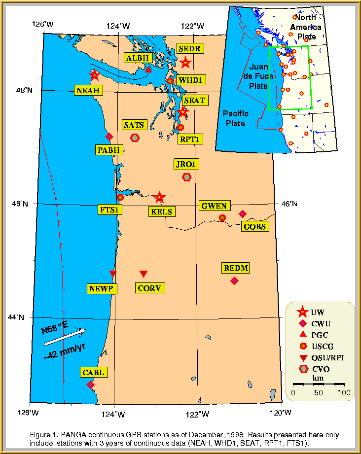
The Pacific Northwest Geodetic Array (PANGA) (Figure 1) is a network of continuously recording GPS receivers operated by several academic and government institutions. In Washington and Oregon the collaborating institutions include the University of Washington (5 GPS receivers), Central Washington University (5), Oregon State University (2) and the Cascade Volcano Observatory (2). The instruments they operate, together with receivers operated by the US Coast Guard and the Geological Survey of Canada constitute the PANGA array. USGS Grant 98HQGR1027 partially supports the receivers operated by UW: sites NEAH, SEAT, SEDR, KELS in Washington, and BURN in Oregon. Some support for these sites also comes from the National Science Foundation.
For the most part the UW receivers have worked well. However, on August 5, 1998 our Ashtech receiver at Neah Bay was stolen together with a modem and UPS unit. The antenna was untouched. By September 22 we increased security at the recording hut and reinstalled an Ashtech receiver we had been using at Seattle (SEAT). Because the antenna at Neah was untouched there should be little effect on future data. However, we were forced to replace the receiver and antenna at SEAT with a Trimble 4000 SSI receiver that we had on hand.
The only other problem we had was an outage caused by a faulty telephone line at KELS that the phone company repaired. Finally, because the receiver at SEDR is located in an equipment box that is exposed to the direct sun, we have had a sun shield manufactured that we plan to install early in 1999.
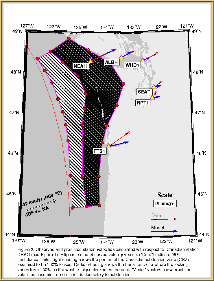
We have done daily analysis of GPS data from several GPS sites in the Pacific Northwest using Gipsy II software from JPL. This analysis has used JPL's fiducial orbits and clocks for a three-year period. Besides the stations shown in (Figure 2) (including USCG stations WHD1, RPT1, and FTS1 and Canadian station ALBH) we have analyzed IGS stations DRAO, ALGO, FAIR, KOKB, and NLIB. Ambiguity resolution has been performed and station locations have been transformed to the ITRF96 reference frame.
As seen in (Figure 2) the observed horizontal velocities of the stations relative to Canadian station DRAO are 5.9, 9.4, 10.7, 2.9, 3.4, and 6.0 mm/year at stations ALBH, FTS1, NEAH, RPT1, SEAT, and WHD1 respectively. The 95% uncertainties in these values are also illustrated and average about 0.4 mm/yr. We have also calculated uplift rates but with less certainty. The most significant uplift occurs at NEAH where the rate is 3.8 mm/yr (relative to DRAO).
Figure 2 also shows the results of trying to model the observed station velocities. We have used a 3-D velocity model using the technique of Fluck et al., 1997. The model allows us to use a three-dimensional dislocation surface and also permits us to assume that the deforming plates are either 100% locked or partially locked at the Cascadia subduction zone. We use a combination of a shallow zone to the west that is 100% locked and a "transition" zone further east for which the fault surface varies linearly from 100% locked to 0% locked. Figure 2 illustrates the results of this model where the relative convergence rate between the Juan de Fuca plate and North America is assumed to be north 69 degrees east and the convergence rate is 42 mm/yr. We find that the locked zone must be very wide in Northwest Washington, the region where the Juan de Fuca plate is known to have a very shallow dip from the analysis of earthquake hypocenter data. Also, the observed directions of the station velocities can not be completely matched using this simple model. The difference between the model velocities and the observed ones requires that forces other than those caused by subduction must be at play. It appears that western Washington is also being compressed in a NS direction, a result that is at least partially consistent with a model proposed by Wells et al., 1998.
We also have been analyzing GPS campaign data for about 70 stations in western Washington. Some of these stations have been occupied in at least 3 different years and preliminary results have been reported by Khazaradze et al., 1998. Some of the sites appear to have velocities that are anomalous but we are not sure yet whether this conclusion is real or due to errors in data collection. We plan to confirm the calculations at these station by means of additional campaign data to be obtained in 1999.
The National Geodetic Survey occupied several hundred survey monuments in Oregon and Washington using GPS in August-November 1998 (see http://www.fs.fed.us/database/gps/harn/reobs98.htm). UW participated in this survey as well as many other government agencies and private local surveyors. These data will help to vastly improve future GPS campaign surveys in the Pacific Northwest. Some of the sites surveyed correspond to sites previously occupied by the USGS and the UW so that these new NGS data will be immediately useful to compare with older results.
The GPS data from stations NEAH and SEAT are available via anonymous ftp at ftp.geophys.washington.edu (change directory to pub/gps) or go to the website http://www.geophys.washington.edu/GPS/ The data for most PANGA stations are available at the PANGA data processing center at http://panga.cwu.edu or at the Scripps Orbit and Permanent Array Center (SOPAC) http://lox.ucsd.edu.
The University of Washington operates 5 continuously recording GPS sites as part of the PANGA network in the Pacific Northwest. Analysis of GPS station movement at GPS sites that have been in operation for three years indicates that crustal deformation in western Washington comes from two sources: 1) subduction of the Juan de Fuca under North America and 2) a north-south compression, presumably due to the the northward motion of the Sierra block in California.
Wihin a year we will have reasonable station velocity measurements at other sites in the PANGA array that have been installed since 1997. Additional GPS campaign measurements will permit us to monitor deformation at much better spatial resolution than are available with continuous stations. The campaign measurements the UW has collected so far are in general agreement with the continuous station measurements but some sites show anomalous velocities that need to be confirmed with further campaign data collection in 1999.
For further information on GPS work at UW see http://www.geophys.washington.edu/GPS/.
Qamar, A; Khazaradze, G; Dragert, H, Crustal Deformation in Western Washington from Continuously Recording GPS, Am. Geophysical Union Annual Meeting, Dec., 1998, San Francisco, Abstract G71F-05.
Khazaradze, G; Qamar, A; Endo, E, Interseismic Strain Accumulation in Western Washington from Campaign-mode and Continuous GPS Measurements, Am. Geophysical Union Annual Meeting, Dec., 1998, San Francisco, Abstract T41A-03
Miller, MM; Rubin, C M; Endo, E; Freymueller, J T; Goldfinger, C; Kelsey, H M; Humphreys, E D; Oldow, J S; Qamar, A, Preliminary GPS Results From the Cascadia Margin: The Pacific Northwest Geodetic Array (PANGA) Am. Geophysical Union Annual Meeting, Dec., 1998, San Francisco, Abstract G31A-05.
Fluck, P., R.D. Hyndman. GC Rogers, and K. Wang, Three-dimensional dislocation model for great earthquakes of the Cascadia subduction zone, J. Geophys. Res., 102, 20539-20550, 1997.
Wells, RE, CS Weaver, and RJ Blakely, Fore-arc migration in Cascadia and its neotectonic significance, Geology, 26, 759-762, 1998.
Back to:...
UW GEOPHYSICS PROGRAM ..... SEISMOLOGY INFO.....
PNW EARTHQUAKES
University of Washington Dept. of Earth and Space Sciences, Box 351310 Seattle, WA, 98195-1310