Information contained in this report is preliminary,
and should not be cited for publication.
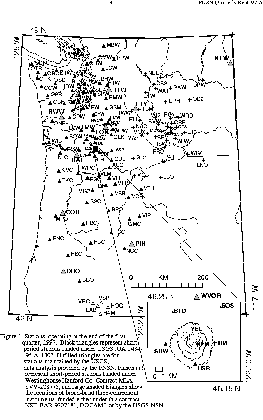
Seismograph network operation in Washington and Oregon is supported by the state of Washington and the following contracts: U.S. Geological Survey Joint Operating Agreement 1434-95-A-1302 and Contract 259116-A-B3 from the Pacific Northwest National Laboratory, operated by Battelle for the U.S. Dept. of Energy
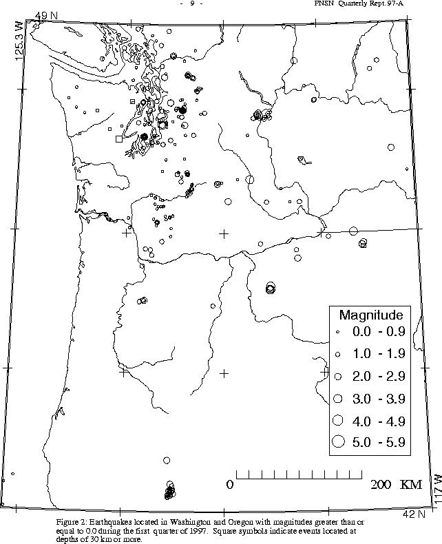
Two earthquakes were reported felt in Oregon this quarter. The largest, on March 22 at 06:05 UTC, was magnitude 3.9 and located at a shallow depth (<1km) near Condon, Oregon, where it was felt by several people. It was preceded by a magnitude 2.7 foreshock at 05:55, and followed the next day by a double aftershock (two shocks, each magnitude 3.1) at 04:39 and 04:40 UTC March 23. An additional magnitude 2.6 aftershock occurred on March 28. Neither t he foreshock nor the aftershocks have been reported felt.
The other Oregon earthquake felt this quarter was magnitude 2.4, and
occurred on January 19 at 18:03 UTC. It was located at about 16 km depth
near the town of Scotts Mills, close to the location of a damaging
(magnitude 5.6) earthquake in March of 1993.
During the first quarter of 1997, 270 earthquakes were located between 45.5-49.5 degrees north latitude and between 121-125.3 west longitude. The deepest earthquake this quarter was a magnitude 1.5 event on March 10 at 09:14 UTC at a depth of about 54 km, located about 10 km northwest of Tacoma.
Four earthquakes were reported felt in western Washington this quarter. The largest was a magnitude 3.5 earthquake which occurred on Feb. 10 at 04:26 UTC. This earthquake was located directly below Seattle at a depth of about 6 km, and was felt by many people in the city. An unfelt aftershock of magnitude 2.0 followed at 04:39 UTC. The focal mechanism for the magnitude 3.5 earthquake indicates thrusting on east-west striking fault planes. The location and mechanism of this event suggest that it may have occurred on or near the Seattle fault.
On Feb. 6 at 22:17 UTC a magnitude 2.3 earthquake at a depth of about 3 km was f elt by a few people in North Bend. In southwestern Washington, two tiny (magnitudes 0.8 and 1.4) very shallow (within a few km of the surface) earthquakes were felt by a few people in Randle on Feb. 1 at 10:10 and 11:31 UTC.
No felt earthquakes occurred this quarter in the Duvall area, where a magnitude 5.4 earthquake occurred in May of 1996. In the second quarter of 1996, when the mainshock occurred, 382 earthquakes were located near Duvall. In the third quarter of 1996 57 earthquakes were locat ed in the area, and in the fourth quarter 25. This quarter only 16 earthquakes were located near Duvall, none larger than magnitude 2.1.
A total of 47 events (20 of them smaller than magnitude 0., and thus not shown in Fig. 4) were located within the region shown in Fig. 4. Of these, 13 (8 of them smaller than magnitude 0., and thus not shown in Fig. 4) were located in the "Western Rainier Seismic Zone" (WRSZ), a north-south trending lineation of seismicity approximately 15 km west of the summit of Mt. Rainier (for counting purposes, the western zone is defined as 46.6-47\(de N latitude, 121.83-122\(de W longitude). Closer to the summit (within 5 km), there were 25 tectonic-style earthquakes. Although 60 "L" or "S" events were recorded this qu arter, none were locatable. (Types L and S are not shown in Fig.4 in any case.) The remaining events were scattered around the cone of Rainier as seen in Fig. 4.
During the first quarter of 1997, 51 earthquakes were located in eastern Washington. One was reported felt. It occurred on March 26 at 03:10 UTC, had magnitude 3.0 and was located at a depth of about 1 km near Walla-Walla.
The largest quake in eastern Washington this quarter was magnitude 3.7. It occurred on January 1, at 22:26 UTC. It was located at about 20 km depth approximately 20 km north-northeast of Yakima, and was not reported felt.