Information contained in this report is preliminary,
and should not be cited for publication.
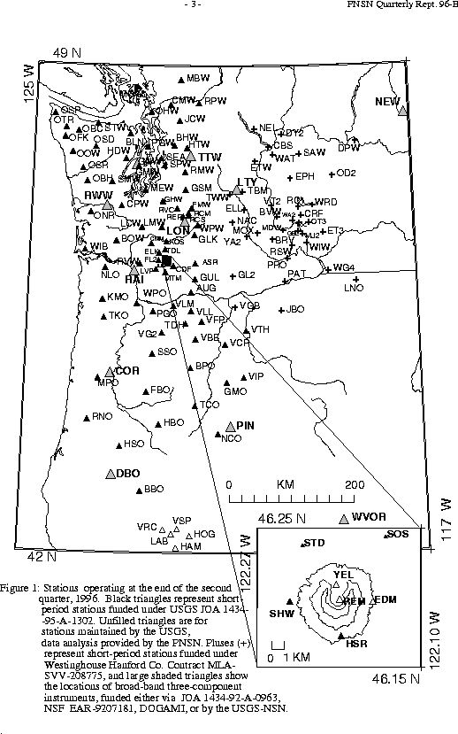
Seismograph network operation in Washington and Oregon is supported by the state of Washington and the following contracts: U.S. Geological Survey Joint Operating Agreement 1434-95-A-1302 and Westinghouse Hanford Company Contract MLA-SVV-208775
The PNSN operates seismograph stations in Washington and Oregon.
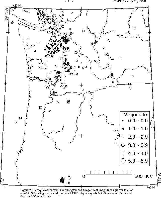
Figure 2 shows seismicity in Washington and Oregon during the second quarter
Three earthquakes were reported felt in Oregon this quarter, including the largest Oregon earthquake this quarter; a magnitude 3.8 that occurred at about 17 km depth near Klamath Falls on April 7 at 18:33 UTC. The other two felt earthquakes in Oregon occurred on April 7 at 13:17 UTC at Mount Hood (magnitude 3, 4 km depth; only one call was received, from a TV station), and on May 16 at 05:10 UTC (magnitude 2.3, depth 29 km; felt by a few persons in the Charleston area of Coos County). Location quality for the May 16 earthquake is poor, as this event is on the extreme south-western edge of our network area.
.
During the second quarter of 1996, 750 earthquakes were located between 45.5 and 49.5 degrees north latitude and between 121 and 125.3 degrees west longitude. The deepest earthquake this quarter (M 1.1, depth approx. 82 km, on May 28 at 23:27 UTC) occurred near Skykomish.
The largest event in Western Washington this quarter was the magnitude 5.4 Duvall earthquake on May 3 at 04:04 UTC (May 2, at 9:04 PM PDT). This earthquake was the largest to occur in the Puget Basin since the 1965 magnitude 6.5. A special report on the Duvall sequence follows. Of the 28 earthquakes reported felt in western Washington this quarter, all but 2 of were in the Duvall sequence. However, our listing of felt events in Duvall is incomplete. The early part of the sequence included many events that were probably felt, but with such an active sequence it was hard to distinguish exactly which events were being reported. Several other effects add to the confusion; after such a widely felt shock the population becomes simultaneously jaded and hyper-sensitive; we receive felt reports for times when no earthquakes occurred, but sometimes do not receive felt reports although earthquakes likely to have been felt occurred.
The remaining two felt events were both deep crustal earthquakes; magnitude 2.9 on April 2 at 17:29 UTC at about 23 km depth - felt by a few persons in Carnation, North Bend and Snoqualmie; and magnitude 3.0 on June 23 at 23:37 UTC at about 19 km depth - felt in Hoodsport and Port Orchard.
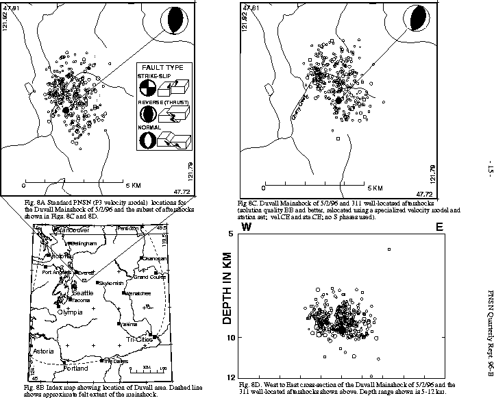
The magnitude 5.4 Duvall mainshock occurred on May 2 at 9:04 PM PDT (May 3, 04:04 UTC). The epicenter, approximately 9 km east-northeast of Duvall, Washington, is nearly coincident with the epicenter estimated for the similar sized 1932 earthquake discussed below. The epicentral region is sparsely populated, and only one residence is located within 2 km of the mainshock. Structural damage appears to be restricted to a single facility, a BPA power station located near Monroe, Washington. Earthquake related road failure occurred on two unpaved roads east of the epicentral area (sections 19 and 33, T27N, R8E). The larger failure was about 140 m in length with about 45 cm lateral and vertical displacement. Additionally, evidence for several earthquake-induced rock failures was observed on a hill south-southeast of Cedar Ponds Lake (section 29, T27N, R8E). Ralph Haugerud, USGS geologist, estimated the largest failure to have a volume between 200 and 2,000 cubic meters. He noted no evidence of liquefaction during an aerial reconnaissance. Reports of subsequent earthquake-related failure in a parking structure in Bellevue were erroneous; City of Bellevue Building Officials attribute the failure to gravity and construction techniques. No evidence of mainshock-related surface rupture in the epicentral area has been reported.
The mainshock was felt most strongly in the Duvall-Monroe area where residents reported items knocked from shelves and broken china and glassware. The earthquake was felt moderately by many residents throughout the Puget Sound area from Olympia to southern British Columbia. The earthquake was felt by a few as far away as Portland, Oregon, and Pasco, Washington. The total area over which the earthquake was felt, shown in
The map was compiled from 845 individual intensities computed from a questionnaire which the UW provided via the World-Wide-Web. The questionnaire consisted of short questions with multiple choice answers, and the numeric intensity was computed by assigning point values to the possible responses, and weighting the questions. The "felt form" and the algorithm for interpreting it was suggested to us by Dr. Lori Dengler of Cal. State Humboldt. Some individual reports were for shaking stronger than the value shown on
Both P-wave first motions recorded on the short-period array and moment-tensor solutions from three-component seismograms recorded on the broadband array reveal that the mainshock had a thrust mechanism with an east-west compression axis. First-motion focal mechanisms are shown in
Seismograms from the PNSN broadband array provide an independent estimate of the focal mechanism and also allow determination of the total seismic moment, which can provide insight into the stress release during the earthquake as well as the rupture area. Moment tensor inversions were carried out by three independent research groups (OSU, UW, and UC Berkeley) using slightly different procedures and data. All three groups obtained very similar results. Here is the
Aftershock activity versus time is shown in
Preliminary analyses of aftershock locations do not indicate an alignment of aftershocks along a fault plane.
Relocation of Duvall Aftershocks
The mainshock and aftershocks were relocated using a master-event technique to improve the precision of locations and depth estimates. A set of 27 well-located earthquakes with readings from close-in USGS temporary stations within 1 or 2 km of the epicentral locations was used to determine station corrections. A map view and West-East cross section are presented in
Earthquake History of the Duvall Area
The most significant historic earthquake in the Duvall Area prior to May, 1996 was the well known "Tolt River Earthquake", which occurred on the evening of July 17, 1932, at 10:30 PM. The estimated location of the 1932 earthquake, based on instrumental recordings at Victoria and Seattle, and on the area of greatest intensity of shaking, was 47.75N 121.83W (Bradford and Waters, 1934, Bull. Seism. Soc. Am., V. 24, pp. 51-62); almost exactly at the location of the May 2, 1996 event (47.76N, 121.85W). Magnitude estimates for the 1932 earthquake have been based on the total area over which the earthquake was felt using a simple formula proposed by Toppozada (1975):
Magnitude = -1.88 + 1.53 log (A)
Where A is the felt area in square km. The estimated magnitude of the 1932 earthquake range from 5.1 to 6.2, the wide variation is because there are huge discrepancies in the felt areas given by various sources.
Bradford and Waters (1934) conducted the most extensive investigation of the felt area, and their estimate was that the earthquake was felt over an area of 70,000 square miles, corresponding to a circle of radius 150 miles (240 km). This would suggest a magnitude of 6.2. Bradford and Waters state that the 1932 earthquake was felt as far as Chehalis and Centralia in the south (150 miles), to Coulee City and Concunully to the east (150 miles), to Bellingham and Vancouver to the north (75 miles), and that the western felt extent was not known. The lower magnitude estimate of 5.1 results from the felt area of 14,000 square miles (corresponding to a circle of radius 67 miles) given in "Earthquake History of the United States" (1973), which references the felt-area map given in "US Earthquakes" (1932). The true magnitude of the 1932 earthquake is likely to lie somewhere between these estimates, as Bradford and Waters appear to have overestimated the felt area, and \fIUS Earthquakes\fR has clearly underestimated it.
The felt area of the 1932 earthquake, as described by Bradford and Waters, approximates that of the 1996 earthquake. However their isoseismal contours are quite dissimilar to those estimated by our preliminary analysis of our World-Wide-Web intensity survey. Our estimated intensities for the 1996 event in Seattle are about one unit higher than Bradford and Waters' estimates for the 1932 event. Because techniques for assigning intensities have varied over time, and were still being developed in 1932, differences in the isoseismal contours for the 1932 and 1996 events could result solely from differences in the survey techniques used.
The 1932 earthquake, according to Bradford and Waters, was almost everywhere described as being accompanied by a roar, a noise like the "rushing of wind", or by explosive-like noises. Similarly, observers near the epicenter of the 1996 Duvall earthquake reported hearing loud noises during the quake.
"US Earthquakes", an annual publication of the Coast and Geodetic Survey, describes a significant sequence of foreshocks prior to the 1932 Tolt River earthquake. The table below lists earthquakes reported by "US Earthquakes" in the vicinity between 1928 and 1932. No further earthquakes were reported in that immediate area until 1952.
The sequence began in 1928 with a 4:52 AM earthquake that cracked plaster in Startup, WA. A newspaper report from the Seattle Post-Intelligencer of Feb. 3, 1928 reports: "Residents of all parts of Seattle, Issaquah, Sultan, and other sections of northwest Washington reported the temblor which awakened them during the night. The university scientists first reported that no quake was registered, but continued reports of the upheaval caused a second check with the magnifying glass, and it was then learned that a quake had occurred." They go on to state that "Two sharp shocks were reported at Index, Sultan, Startup, Goldbar and Monroe...Stephen Mitchell, Everett city building inspector, reported that another shock at 3:30 rocked his bed."
No earthquakes were reported in "US Earthquakes" in 1929, one was reported in 1930 and five in 1931. In January 1932, an earthquake near Sultan was strong enough to stop a pendulum clock at the Seattle weather bureau and disturb pictures in Everett (Everett Daily Herald, Jan. 6, 1932), and was described as a "hair raising thrill" in Monroe (Monroe Monitor, Jan. 8, 1932). According to "US Earthquakes", this was followed by three additional foreshocks, the mainshock, and three aftershocks, all in 1932. (However, no newspaper account could be found that mentioned the largest listed aftershock, Aug. 6; nor was it mentioned in the Bradford and Waters (1934) article).
TABLE I.
List of Earthquakes reported by \fIUS Earthquakes\fR in the Sultan area, 1928-1932
Year	Date	Time	Place			Description
		(Local)
1928	Feb. 2	04:52	Startup (47.8N, 121.7W)	Generally felt.
						Strong shake and roaring.
						Cracking of plaster and paper.
						People generally alarmed.
1930	Aug. 18	23:05	Sultan (47.8N, 121.8W)	Slight
1931	Jan. 20	23:10	Sultan (47.8N, 121.8W)	Slight
1931	May 28	23:10	Sultan (47.8N, 121.8W)	Feeble
1931	June 11	23:30	Sultan (47.8N, 121.8W	Feeble
1931	Aug. 19	07:05	Sultan (47.8N, 121.8W)	Feeble
1931	Dec. 29	00:27	Sultan (47.8N, 121.8W)	Feeble
1932	Jan. 5	15:13	Sultan (47.8N, 121.8W)	Moderate,
						superficial damage in Monroe
1932	Feb. 10	23:10	Sultan			MM Intensity III
1932	Feb. 19	12:13	Sultan			MM Intensity III
1932	June 13	10:30	Sultan			Feeble
1932	July 17	22:03	Sultan			Mainshock, see comments
1932	Aug. 6	22:00	Sultan			Moderate, MM Int. IV
1932	Aug. 30	23:50	Sultan			MM Intensity III
1932	Sept. 19 23:05	Sultan			MM Intensity III,Slight
1952	Feb. 23	01:07	Duvall			Reported felt
PNSN Response to moderate-sized earthquakes including the Duvall Earthquake
The magnitude 5.4 Duvall earthquake was the second magnitude 5+ earthqua ke within the Puget basin in about 18 months, and the fourth damaging earthquake in the PNSN area during the past approx. 3 years. Following the Duvall earthqua ke, an automatically generated e-mail and pager alert was sent out within 62 seconds (the first preliminary magnitude estimate was 4.3), and the seismologist on duty called the Washington Dept. of Emergency Management (DEM) within 130 seconds. Within 12 minutes, staff (and the press!!) began to arrive at the Lab, and within 16 minutes we were able to provide DEM with a good location estimate and a 5+ estimate of the magnitude. Our audio library was updated 18 minutes after the earthquake and our Web-site was updated with a special section on the Duvall sequence within a few hours.
While the PNSN responds to several dozen felt earthquakes every year, damaging earthquakes occur less frequently, but pose special problems from an operational perspective. Recent seismicity (Scotts Mills OR, March 1993; Klamath Falls OR, Sept. 1993; Robinson Point, Jan. 1995; Duvall, May 1996) has provided us a test of our procedures, and a useful opportunity to examine what happens at the PNSN during an emergency situation. Minor operational problems following the Duvall event included congestion in the Lab caused by the press, failure of automatic data-retrieval programs to fetch broad-band data, and a network jam caused by intense Web activity.
In the past few years we have expanded our communications ability to include automatically generated faxes and e-mail messages, and automatic updates of information posted o n the World-Wide-Web. In addition we now have a radio link to the Washington S tate Dept. of Emergency Services, and a direct phone link to the City of Seat tle EOC. These enhancements produce new expectations on the part of our clients, and new responsibilities for us.
A PNSN seismologist is always on duty, and our standard procedure is to respond to pages from our automatic earthquake detection process (for any earthquake within our network of magnitude 2.9 or larger), or from Washington or Oregon emergency management agencies, or the UW police. Our automatic detection process generates PRELIMINARY faxes and electronic mail for earthquakes that it judges M>= 2.9. Following a sizable felt earthquake, we have many responsibilities all demanding immediate attention. These responsibilities can be grouped as communication, data acquisition and analysis, and interpretation. These areas are tightly interconnected, as we attempt to rapidly calculate and communicate the best estimates of location, depth and magnitude, while simultaneously tracking aftershocks, planning field operations, and interpreting the tectonic significance of the event while staying in close communication with emergency managers.
Following the Duvall earthquake, the PNSN Seismology Lab served as a communications center for field crews installing strong motion and other instruments to record aftershocks of the Duvall event. Two press conferences were held. The first, organized with the help of L.G. Blanchard of UW News and Information, was a briefing for all media, and was held at UW a few days after the main shock. The second was arranged by the Seismology Lab for television news providers and took place at a temporary USGS seismometer site near the epicenter. Both press conferenc es resulted in excellent coverage by all regional TV news programs. In addition, PNSN Lab Coordinator Bill Steele arranged many press interviews and one-on-one matching of reporters and scientists to provide press coverage of field operations.
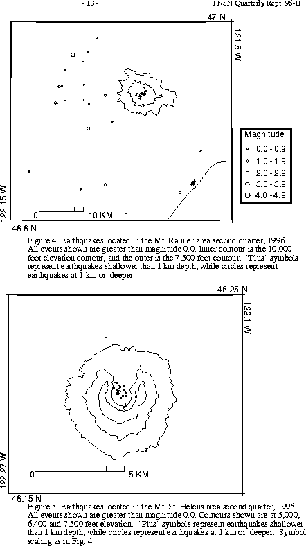
A total of 59 events (11 of them smaller than magnitude 0., and thus not shown in Fig. 4) were located within the region shown in Fig. 4. Of these, 21 were located in the "Western Rainier Seismic Zone" (WRSZ), a north-south trending lineation of seismicity approximately 15 km west of the summit of Mt. Rainier (for counting purposes, the western zone is defined as 46.6-47\(de N latitude, 121.83-122\(de W longitude). Closer to the summit (within 5 km), there were 20 earthquakes, but no type "L" or "S" events were located this quarter (types L and S are not shown in Fig.4). The remaining events were scattered around the cone of Rainier as seen in Fig. 4.
During the second quarter of 1996, 40 earthquakes were located in eastern Washington. The largest quake in eastern Washington this quarter was on June 25 at 07:30 UTC. It was magnitude 3.0 and was located at a depth of about 17 km near Ephrata, where it was reported felt to the Grant County Dept. of Emergency Management.