Seismic Velocity Structure of the Greater Mount Rainier Area
1434-95-G-2571
Stephen D. Malone, P.I.
Dept. of Earth and Space Sciences, University of Washington
Seattle, WA 98195
Phone:(206) 543-8020 FAX:(206)543-0489
e-mail: steve@ess.washington.edu
Program Element: II.1 and II.2
Keywords: Seismotectonics, regional seismic hazards, regional modeling
Investigations undertaken
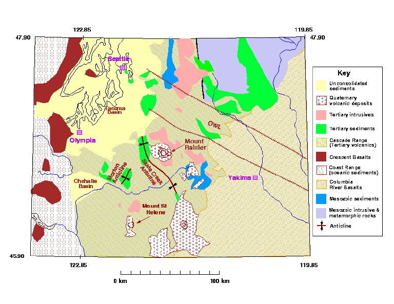
Th goal of this project is to determine the detailed three-dimensional velocity structure of southwestern Washington (Figure 1) by using first arrival data from natural earthquakes recorded on the Pacific Northwest Seismograph Network (PNSN) and 18 temporary stations. These arrival-time data are used in a non-linear tomographic inversion for 3-D velocity structure and hypocenter parameters.
Results
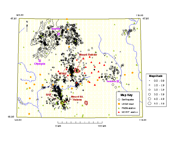
This project is nearing completion, and results will be published shortly in a Ph.D. dissertation (Moran, 1997). The field component of this project was completed in July of 1996. The 18 planned temporary seismograph sites were each occupied for 4-6 months (see Figure 2). Two of these sites are still in operation, and have been incorporated into the PNSN. The number of P arrivals recorded by the 18 temporary stations met or exceeded our expectations of ~100 earthquakes per station in all but three cases.
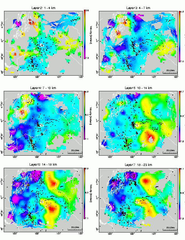
The computational component of our project is also completed. We modified existing code developed by Lees (1989) to perform a non-linear inversion for P-velocity structure. We used the parameter separation approach of Spencer and Gubbins (1980) to explicitly address the coupling between hypocenter and velocity parameters. 6 layers in our 3-D velocity model are shown in Figure 3.
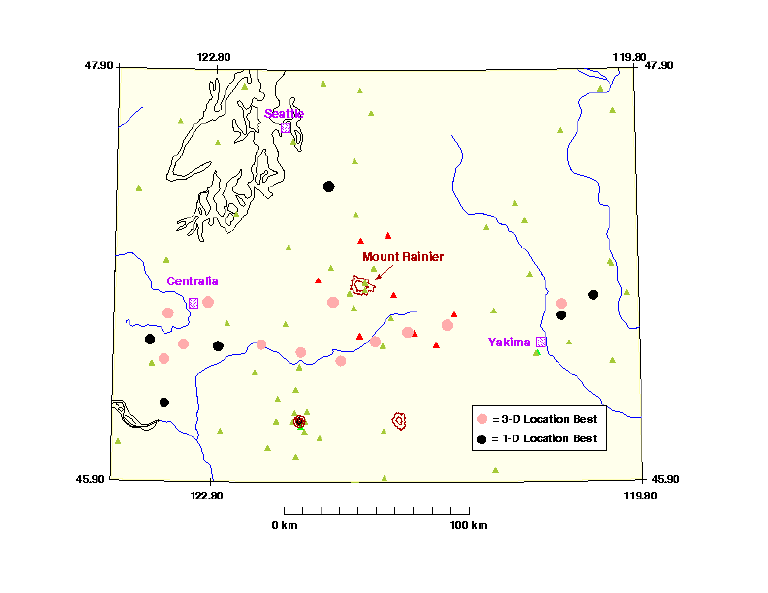
We assessed the reliability of the resultant 3-D velocity model both by standard means (such as the Checkerboard and Jackknife methods for estimating resolution and parameter variance, respectively) as well as the amount of error associated with the relocations of 32 well-recorded blasts from the 1991 and 1995 USGS-OSU-UBC-UTEP refraction profiles (Figure 4).
We are currently nearing completion of the interpretational phase of the project. Several significant features are apparent in our model, which we discuss briefly here. There is good correlation between the first 2 layers in our model and local geology (Figure 1). In particular, Tertiary intrusions (pink areas in Figure 1) correspond with high velocity anomalies, Tertiary sediments coring the Skate Creek and Morton anticline (green areas in Figure 1) correlate with low velocity anomalies, and the Seattle, Tacoma and Chehalis basins (all with at least 5 km of consolidated sediments) correlate with very low velocity anomalies.
In addition, the St. Helens seismic Zone (SHZ in Figure 2) correlates with a north-south-trending low velocity trough extending from Layer 1 to at least Layer 4 (1 - 14 km). If this trough represents a fault or zone of faults, then its length is consistent with a maximum magnitude earthquake of M 6.5. Conversely, the Western Rainier Seismic Zone (WRSZ in Figure 2) does not appear to correlate with any anomaly patterns, suggesting that WRSZ is controlled by several discontinuous structures. We infer from this lack of correlation that the maximum magnitude earthquake should be on the order of the largest recorded to date (M 4.1), and that the hazard posed to Mount Rainier by the WRSZ is small.
References
Lees, J.M., Seismic tomography in western Washington, Ph.D. thesis, 173 pp., Univ. of Wash., Seattle, 1989.
Spencer, C., and D. Gubbins, Travel-time inversion for simultaneous earthquake location and velocity structure determination in laterally varying media, Geophys. J. R. Astr. Soc., 63 R, 95-116, 1980.
Moran, S.C., Three-dimensional P-wave velocity structure in southwestern Washington from local earthquake tomography, Ph.D. thesis, Univ. of Wash., Seattle, in press, 1997.
Moran, S.C., J.M. Lees, and S. D. Malone, Three-dimensional P-wave velocity structure in southwestern Washington from local earthquake tomography (abstract), EOS Trans. AGU, 77(46), Fall Meet. Suppl., p. F466, 1996.
Moran, S.C., J.M. Lees, and S. D. Malone, P-wave tomography in western Washington using regional network recordings of controlled source experiments: Results and interpretations (abstract), GSA Abstracts with Programs, 28, p. A-195, 1996.
Moran, S.C., J.M. Lees, S.D. Malone, P-wave tomography at Mount Rainier, Washington: Preliminary results (abstract), EOS Trans. AGU, 76(46), Fall Meet. Suppl., p. F644, 1995.
Malone, S.D., S.C. Moran, Mount Rainier; Washington, USA: Tectonics, seismicity, and hazards, Volcanoes in Town , IAVCEI conference on volcanic hazard in densely populated regions, Periodico di Mineralogia, Roma (extended abstract), p. 49-52, 1995.