Pacific Northwest Seismograph Network Operations 1434-95-A-1302 S.D. Malone, R.S. Crosson, and A.I. Qamar, P.I.s Dept. of Earth and Space Sciences, University of Washington Seattle, WA 98195 (206) 543-8020 e-mail: steve, bob, tony, or ruth@ess.washington.edu
Oct. 1, 1994 - Sept. 30, 1995
Investigatations
Operation of the Pacific Northwest Seismograph Network (PNSN) and preliminary analysis of earthquakes in Washington and Oregon continues under this agreement. The PNSN operates 96 stations west of 120 degrees west longitude under this agreement, and 51 additional stations under other support. Quarterly bulletins which provide operational details and descriptions of seismic activity in Washington and Oregon are available from 1984 through the third quarter of 1995. Final published catalogs are available from 1970, when the network began operation, though 1989. A 1990-1994 catalog is in preparation.
Network Operations
This year, we implemented changes in both our seismic trace data and pickfile (phase arrival times) formats (and associated data-processing software). The old formats, in use since 1980, did not allow broad-band data to be merged into our network data stream. Our new trace data format (UW-2) can accommodate data of varying durations, sample rates, and start times; is extensible without affecting existing processing programs; and is backward-compatible with our original (UW-1) format. . The new format allows us to merge broad-band data from our five broad-band stations, from the National Seismograph Network station NEW in Newport, Washington, and from stations operated by Oregon State University and the University of Oregon. The new UW-2 pickfile format provides full support for three-component stations and a number of other advantages, and is also backward compatible. Interactive viewing of both trace and pickfile data is provided through Xped (X pick editor), an X window application that allows the user to display trace and pick information and to perform data analysis functions.
In addition to the extensive modifications of data-processing software required by the change to UW-2 data formats, we have updated our data acquisition hardware and software. The new data acquisition software is called SUNWORM , and was developed in cooperation with the EARTHWORM project at the USGS in Menlo Park. It runs on a SUN-SparcStation-5 workstation, and replaced our previous HAWK software system (which ran on a Concurrent 5600 computer from 1988-1994) at the end of 1994.
Seismic trace data from 1980-1989, and from 1992-1994, have now been reformatted to the IRIS-SEED format and submitted to the IRIS Data Management Center, where they will be made available over Internet through the IRIS data-base system. Reformatting of the remaining data will be completed in the near future
Seismicity
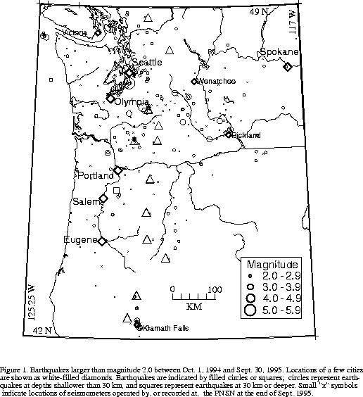
Figure 1 shows earthquakes of magnitude 2.0 or larger located in Washington and Oregon during this reporting period. The PNSN processed 5,067 events between Oct. 1, 1994 and Sept. 30, 1995. Of these, 4,123 were earthquakes or blasts within the network (1,305 of which were too small to locate). Within our network area, 2,274 earthquakes were located west of 120.5 degrees west longitude, (including 617 near Mount St. Helens, which has not erupted since 1986), and 192 east of 120.5 degrees west longitude. The remaining events were blasts within the network, regional earthquakes (297) or teleseisms (647).
During this reporting period there were 19 earthquakes reported felt west of the Cascades, ranging in magnitude from 2.1 to 5.0, and four (magnitudes 2.1-3.3) felt east of the Cascades.
In Oregon, a total of 7 earthquakes were reported felt, four of them in the Klamath Falls area, where a pair of damaging earthquakes in September of 1993 (Sept. 21, 03:29 and 05:45 UTC; x 5.9 and 6.0 respectively), were followed by a vigorous aftershock sequence which has decreased over time. The Woodburn, Oregon area (where the magnitude 5.6 "Scotts Mills" earthquake of March 25, 1993 occurred) was also a source of several felt earthquakes.
The largest earthquake during this reporting period was the magnitude 5.0 Robinson Point earthquake of 29 January 1995 at 03:11:22 PM UTC (28 January 1995 at 07:11:22 PM PST). It occurred at a depth of 20 km roughly midway between the cities of Seattle and Tacoma; at a map location nearly coincident with the much deeper ( 60 km and much larger (mb = 6.5) 1965 Seattle earthquake. The Robinson Point sequence includes one foreshock (Mc = 1.8 on Jan. 28 at 14:18 UTC), the main shock, and 25 aftershocks recorded through 14 April, 1995. Aftershock epicenters cluster about the mainshock; the hypocenter distribution shows a steeply dipping distribution with the mainshock at the bottom, near 20 km (after relocation with modified station corrections). P-wave first motions from the mainshock indicate reverse faulting with east-west trending nodal planes. Minor damage was reported in Auburn, Tacoma, and Puyallup and shaking was felt throughout western Washington to as far away as Salem, Oregon and Vancouver, British Columbia. This was the first moderate-sized Puget Sound earthquake to be recorded by the three-component, wide dynamic range, broad-band instruments added recently to the PNSN. The broad-band data provide the only unclipped local records of the mainshock.
The second-largest earthquake within our network this reporting period was a magnitude 4.1 earthquake on May 20, at 12:48 UTC at a depth of 13 km in the Western Rainier Seismic Zone (WRSZ), 14 km west-northwest of Mount Rainier. It was felt in Eatonville, Tacoma, Roy, Enumclaw and Yelm, with reports from as far away as Darrington (to the north) and Satsop (to the west). The PNSN located 25 aftershocks in the following week within a 5 km square area centered on the felt event, but the largest aftershock was only magnitude 1.8, and only two aftershocks were larger than magnitude 1.0.
An interesting sequence of events was noted 20 km offshore of the northern Olympic Peninsula; about 60 km west of Forks, Washington and 35 km from the nearest seismograph station, OSP. Although activity in this area is unusual, two earthquakes (magnitudes 2.3 and 2.2) were located there in late January. In June and July 10 earthquakes occurred in the same locale, including two larger than magnitude 3.0.
PNSN Quarterly Reports since 1994 have included moment-tensor focal mechanisms for earthquakes larger than magnitude 3.5 provided by Dr. John Nabelek of Oregon State University (OSU) under support from USGS NEHRP Grant 1434-93-G-2326.
Public Education and Outreach
Staff from the PNSN provide an educational outreach program to better inform the public, policy makers, and emergency managers about seismicity and natural hazards. In addition to information sheets, lab tours, workshops, and media interviews, we have an audio library with several tapes, including a frequently updated message on current seismic activity. Similar information is available via Internet on the World-Wide-Web (WWW):
/SEIS/welcome.html
Outreach highlights this reporting period include: 1,400 calls/month to our audio library, 35,000 public contacts per month through Internet, and Lab tours for over 1,000 students, teachers, and parents. We also participated in a number of special events including "Bill Nye the Science Guy" - a national TV science show for children, "Know your faults"- shown on statewide cable TV, "Sound Shake '95" - a western Washington earthquake response exercise, and "Finding the weak links, Cascadia" - a meeting hosted by PNSN and sponsored by FEMA.
For significant local events, our automatic processing includes an alarm that initiates electronic mail (e-mail) or faxes to local emergency response agencies, operators of adjacent seismograph networks, and the National Earthquake Information Center in Colorado. When the event has been fully processed, updated final information on it is also faxed or e-mailed.
During this reporting period, we collected felt reports from the public following the late-January Pt. Robinson magnitude 5.0 earthquake. These may help identify areas with particularly susceptible soil or site conditions. We received 7,000 completed "Felt report" forms that had been published in newspapers, 1,100 responses through computer e-mail, and 900 responses through the WWW (World Wide Web).
Publications
Reports and Articles
Braunmiller, J., J. Nabelek, B. Leitner, and A. Qamar, 1994, The 1993 Klamath Falls, Oregon, earthquake sequence: Source mechanisms from regional data, Geophysical Research Letters, V. 22, pp. 105-108.
Ludwin, R.S., A.I. Qamar, S.D. Malone, R.S. Crosson, S. Moran, G,C. Thomas, and W.P. Steele (in preparation), Earthquake Hypocenters in Washington and Oregon, 1990-1994, Washington State Dept. of Natural Resources Information Circular
Malone, S.D., 1995, Seismology and the information super-highway, Seismological Research Letters V66, N1, 28-30.
Malone, S.D., 1995, All seismic networks will be part of a global network: the network is the network, IUGG XXI General Assembly Program , Boulder, CO.
Malone, S.D., 1995, More on seismology and the information super-highway, Seismological Research Letters V66, N3, 35-37, 1995
Malone, S.D., 1995, The Internet - undergoing rapid change, Seismological Research Letters V66, N5, 47-48.
Qamar, A. 1995, Space shuttle and meteoroid -- tracking supersonic objects in the atmosphere with seismographs, Seismological Research Letters, v. 66, 6-12.
Qamar, A., and K. Meagher, 1994, Precisely Locating the Klamath Falls Earthquakes with Temporary Seismograph Stations, Earthquakes and Volcanoes, v. 24, no. 3, 129-13
Stanley, W. D., S. Y. Johnson, A. Qamar, C. S. Weaver, and J. M. Williams, (in press), Tectonics and seismicity of the southern Cascades region with a focus on Mount Rainier.
Swanson, D.S., S.D. Malone, T. Casadevall, Mount Rainier, a Decade Volcano , U.S. National Academy of Science Report, 1994.
Univ. of Wash. Dept. of Earth and Space Sciences, 1994, Quarterly Network Reports; 94-D, 95-A,95-B, and 95-C; Seismicity of Washington and Oregon
Abstracts
Khazaradze, G. and S.D. Malone, 1994, Determination of local magnitude using Pacific Northwest Seismic Network Broadband Data, EOS, Vol. 75, Supplement to No. 44, p. 460.
Malone, S.D., 1994, A review of seismic data access techniques over the Internet, EOS, Vol. 75, Supplement to No. 44, p. 429.
Malone, S.D. and S.C. Moran, 1995 (extended abstract), Mount Rainier; Washington, USA: tectonics, seismicity, and hazards, Volcanoes in Town , page 49-52 IAVCEI conference on volcanic hazard in densely populated regions, Periodico di Mineralogia, Roma.
Malone, S.D., 1995 (abstract), SUNWORM: the Pacific Northwest Seismograph Network real-time seismic recording and processing system, EOS , V. 76, No.46, p. F395.
Moran, S. C., A. Qamar, and S. D. Malone, "Seismicity at Mount Rainier, Washington" (abstract), IUGG Abstract Program, p. A452, 1995.
Moran, S.C., and S.D. Malone, 1994, A Seismic refraction profile across the central Washington Cascades: Preliminary Results, EOS, Vol. 75, Supplement to No. 44, p. 621.
Qamar, A., S.D. Malone, and P. Lombard, 1995 (abstract), Automated felt reports from the January 28, magnitude 5, Robinson Point, Washington earthquake, EOS , V. 76, No. 46, p. F430.
Back to:...
UW Dept. of Earth and Space Sciences ..... SEISMOLOGY INFO..... PNW EARTHQUAKES