Information contained in this report is preliminary,
and should not be cited for publication. The on-line version of the quarterly isabbreviated. The complete quarterly is available in paper version on request.
Seismograph network operation in Washington and Oregon is supported by the state of Washington and the following contracts: U.S. Geological Survey Joint Operating Agreement 01-HQ-AG-0011 and Contract 259116-A-B3 from the Pacific Northwest National Laboratory, operated by Battelle for the U.S. Dept. of Energy
There were 2,027 events digitally recorded and processed at the University of Washington between July 1 and September 30, 2002. Locations in Washington, Oregon, or southernmost British Columbia were determined for 837 of these events; 696 were classified as earthquakes and 141 as known or suspected blasts. The remaining 1190 processed events include teleseisms (176 events), regional events outside the PNSN (99), and unlocated events within the PNSN. Unlocated events within the PNSN include surficial events on Mt. St. Helens and Mt Rainier, very small earthquakes, and blasts. Frequent mining blasts occur near Centralia, Washington and we routinely locate them.
Table 3A is a listing of all earthquakes reported to have been felt during
this quarter, events for which
ShakeMaps or Community Internet Intensity Maps (CIIM) are noted.
ShakeMap shows instrumentally measured shaking using data from accleromete rs in the network. Peak ground acceleration (PGA) values between accelerometers are modeled using information about local geology.
CIIM maps are made using "felt" reports relayed via Internet. These "felt" reports are converted into numeric intensity values, and the CIIM map shows the average intensity by zip code.
TABLE 3A: EARTHQUAKES REPORTED FELT, 3rd QUARTER, 2002
    DATE-(UTC)-TIME	LAT(N)	LON(W)	DEPTH	MAG	COMMENTS			CIIM	 SHAKEMAP
  yy/mm/dd hh:mm:ss   deg.   deg.    km

02/07/03 12:22:45   48.93   123.04    14.5    3.0    21.9 km   S of Vancouver,BC
02/07/22 07:27:34   47.40   121.78    28.0    3.1     9.8 km   S of North Bend, WA   x   x
02/07/30 21:20:47   48.03   122.73    58.6    2.6    33.6 km NNW of Poulsbo, WA
02/07/31 09:01:58   47.40   122.17    49.3    2.9    10.3 km   W of Maple Valley, WA
02/08/10 20:23:04   47.68   117.41     0.0   -0.2     1.6 km NNW of Spokane, WA
02/08/24 03:36:16   47.65   120.29     4.3    2.7     5.1 km   W of Entiat, WA
02/09/18 04:37:28   47.57   121.77    11.2    2.0     8.5 km   E of Fall City, WA
02/09/21 00:55:20   48.48   123.12    23.4    4.1    10.6 km WSW of Friday Harbor, WA   x   x
02/09/21 08:07:14   48.52   122.05     0.0    2.5    13.4 km ENE of Sedro Woolley, WA
02/09/25 05:30:54   48.60   121.96     0.0    2.4    17.7 km WNW of Concrete, WA
02/09/25 05:35:49   48.61   121.95     0.0    2.6    17.2 km WNW of Concrete, WA
02/09/25 07:30:55   47.79   121.82     7.2    2.4    13.3 km ENE of Duvall, WA
02/09/26 07:00:04   48.48   123.13    23.1    2.9    11.2 km WSW of Friday Harbor, WA
OREGON SEISMICITY
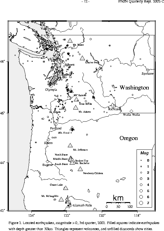
During the third quarter of 2002, a total of 158 earthquakes were located in Oregon between 42.0° and 45.5° north latitude, and between 117° and 125° west longitude. The largest earthquake in Oregon this quarter was a magnitude 2.9 earthquake on July 7 located at a depth of \(ap6 km, about 4 km south-southeast of Mt. Hood volcano.
In the Klamath Falls area, 13 earthquakes were located this quarter. None was larger than magnitude 2.4. Since 1994, most earthquakes in the Klamath Falls area have occurred in the aftershock zone of a pair of damaging earthquakes in September, 1993. The 1993 earthquakes were followed by a vigorous aftershock sequence which decreased over time.
During the third quarter of 2002, 473 earthquakes were located between 45.5° and 49.5° north latitude and between 121° and 125.3° west longitude. Eleven earthquakes were felt this quarter in western Washington. Details are in Table 3A.
The largest felt earthquake in western Washington was a magnitude 4.1 earthquake on Sept. 21 (UTC), located about 10.6 km WSW of Friday Harbor on San Juan Island at a depth of about 23 km. This quake was followed by 17 small aftershocks, including a felt M 2.9 event on Sept. 26 (UTC).
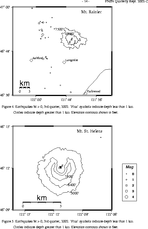
Other activity visible in Fig. 2 included a July cluster of about 8 small (the largest was M 2.1) earthquakes near Darrington, and an Aug. - Sept. cluster of about 5 small (the largest was M 2.5) earthquakes near Sedro Woolley. Near Mt. Rainier a cluster of epicenters, visible in Figure 2, includes several surficial "S" and low-frequency "L" earthquakes not shown in Fig. 4. The deepest quake in western Washington was a magnitude 0.9 earthquake at about 61 km, located about 22 km west-northwest of Bellingham, WA.
The number of events in close proximity to the cone of Mt. Rainier varies over the course of the year, since the source of much of the shallow activity is presumably ice movement or avalanching at the surface, which is seasonal in nature. Events with very low frequency signals (1-3 Hz) believed to be icequakes are assigned type "L" in the catalog. Emergent, very long duration signals, probably due to rockfalls or avalanches, are assigned type "S" (see Key to Earthquake Catalog). There was eight located event flagged "L" at Mount Rainier this quarter although 372 "L" or "S" events were recorded, but were too small to locate reliably. Type L and S events are not shown in Fig. 4.
A total of 69 tectonic events (34 of these were smaller than magnitude 0.0, and thus are
not shown in Fig. 4) were located within the region shown in Fig. 4.
The largest tectonic earthquake located near Mt. Rainier this quarter was a magnitude 2.4 earthquake on July 19 at 20:44 UTC, located about 15 km west of the summit at about 6 km depth. This quarter, 46 of the tectonic earthquakes were located in the "Western Rainier Seismic Zone" (WRSZ), a north-south trending lineation of seismicity approximately 15 km west of the summit of Mt. Rainier (for counting purposes, the western zone is defined as 46.6-47 degrees north latitude and 121.83-122 west longitude).
Within 5 km of the summit, there were 14 (7 of them smaller than magnitude 0.0 and thus not shown in Fig. 4) higher-frequency tectonic-style earthquakes, and the remaining events were scattered around the cone of Rainier as seen in Fig. 4.
This quarter, 126 earthquakes were located at Mount St. Helens in the area shown in Fig. 5. Of these earthquakes, 22 were magnitude 0.0 or larger and 20 were deeper than 4 km. The largest tectonic earthquake at Mount St. Helens this quarter was a magnitude 1.3 event at about 2 km depth on Sept. 25 UTC. It was located .2 km NNE of the dome.
No type "S" or "L" events were located at Mount St. Helens, but 357 "L" or "S" events too small to locate were recorded.
During the third quarter of 2002, 65 earthquakes were located in eastern Washington in the area between 45.5-49.5 degrees north latitude and 117-121 degrees west longitude. Activity in the Spokane area, discussed at length in the 2001-C and 2001-D quarterlies, was minimal during third quarter of 2002. Only one tiny quake (magnitude -0.2), was recorded. It was also reported felt. The largest earthquake in eastern Washington this quarter was magnitude 2.7. It had a depth of about 4 km, and was located 5 km west of Entiat. Entiat is an area with a long-lasting spatial cluster of activity (15 small quakes located there during the third quarter). A quake of approximately 5.0 occurred there in 1959, and the 1872 (magnitude estimated at 6.8-7.4) North Cascades earthquake may have originated in this area.
A spatial cluster of small earthquakes (none larger than M 1.7) north-northeast of Yakima consisted of three temporal clusters - three small earthquakes within 3 minutes on July 13, four earthquake within 10 minutes on July 15, and three earthquakes within 3 minutes on Sept. 2, followed by one more half an hour later.