Information contained in this report is preliminary,
and should not be cited for publication.
Seismograph network operation in Washington and Oregon is supported by the state of Washington and the following contracts: U.S. Geological Survey Joint Operating Agreement 01-HQ-AG-0011 and Contract 259116-A-B3 from the Pacific Northwest National Laboratory, operated by Battelle for the U.S. Dept. of Energy
There were 1,604 events digitally recorded and processed at the University of Washington between April 1 and June 30, 2001. Locations in Washington, Oregon, or southernmost British Columbia were determined for 729 of these events; 584 were classified as earthquakes and 145 as known or suspected blasts. The remaining 875 processed events include teleseisms (218 events), regional events outside the PNSN (102), and unlocated events within the PNSN. Unlocated events within the PNSN include very small earthquakes and some known blasts. Frequent mining blasts occur near Centralia, Washington and we routinely locate some of them.
    DATE-(UTC)-TIME   LAT(N) LON(W)  DEPTH   MAG  COMMENTS					CIIM	 SHAKEMAP
  yy/mm/dd hh:mm:ss   deg.   deg.    km

01/02/14 03:54:54	 48.76	123.12	 20.9	2.3	 26.0 km NNW of Friday Harbor, WA
01/04/07 16:02:35	 48.72	124.76	 41.8	3.9	 90.6 km NNW of Forks, WA		x
01/06/10 13:19:11	 47.16	123.50	 40.7	5.0	 18.3 km   N of Satsop, WA		x	x
01/06/25 14:15:22	 47.68	117.39	 10.5	3.9	  1.3 km NNE of Spokane, WA		x
01/06/25 15:01:27	 47.70	117.41	 11.1	3.4	  3.4 km   N of Spokane, WA
01/06/25 16:49:16	 47.73	117.47	  0.0	2.3	  9.0 km NNW of Spokane, WA
01/06/25 22:58:13	 47.72	117.46	  0.0	2.3	  7.0 km  NW of Spokane, WA
01/06/26 01:21:21	 47.75	117.48	  0.0	2.1	 11.4 km NNW of Spokane, WA
01/06/26 05:52:26	 47.75	117.48	  8.0	2.4	 10.9 km  NW of Spokane, WA
01/06/27 09:07:45	 47.72	117.45	  0.4	2.4	  6.8 km  NW of Spokane, WA
01/06/27 14:45:37	 47.70	117.41	  7.3	2.9	  4.2 km   N of Spokane, WA		x
01/06/28 07:51:42	 47.69	117.43	  0.5	2.1	  3.6 km  NW of Spokane, WA
01/06/28 11:47:48	 47.66	117.41	  0.2	0.7	  1.0 km WSW of Spokane, WA
01/06/29 01:13:27	 47.67	117.41	  0.3	2.3	  1.0 km NNW of Spokane, WA
01/06/30 01:23:31	 46.85	121.97	  7.7	3.3	 16.2 km   W of Mt Rainier, WA		x
In the Klamath Falls area, six earthquakes occurred in the second quarter of 2001. Since 1994, most earthquakes in the Klamath Falls area have been considered aftershocks of a pair of damaging earthquakes in September of 1993. The 1993 earthquakes were followed by a vigorous aftershock sequence which decreased over time.
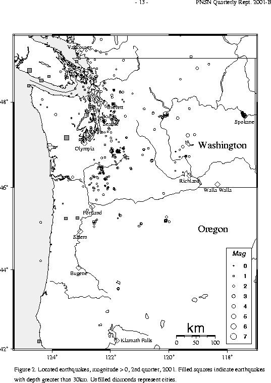
During the second quarter of 2001, 477 earthquakes were located between 45.5° and 49.5° north latitude and between 121° and 125.3° west longitude. Three earthquakes were felt this quarter in western Washington. Details are in Table 3A.
The largest felt earthquake in western Washington was a magnitude 5.0 earthquake
on June 10 at 13:19 UTC. This earthquake was located near Satsop, Washington at a depth of about 41 km.
A larger earthquake (Mw=5.8) occurred nearby (about 11 km SSE) and at a similar depth in July of 1999.
Like the Feb. 2001 Nisqually earthquake, these are Benioff zone earthquakes within the subducting
oceanic plate. The June 10 earthquake was well recorded by strong motion instruments in the Puget Sound.
A ShakeMap is available at:
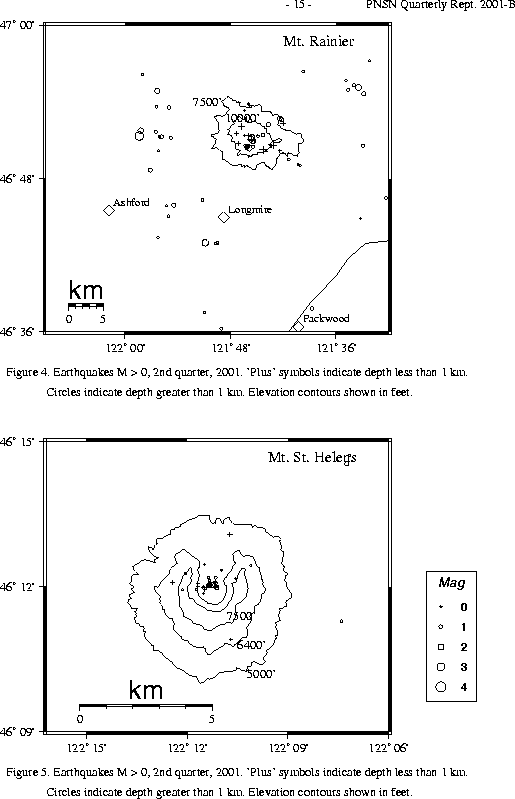
A total of 95 tectonic events (30 of these were smaller than magnitude 0.0, and thus are not shown in Fig. 4) were located within the region shown in Fig. 4. Of these, 30 were tectonic events located in the "Western Rainier Seismic Zone" (WRSZ), a north-south trending line ation of seismicity approximately 15 km west of the summit of Mt. Rainier (for counting purposes, the western zone is defined as 46.6-47 degrees north latitude and 121.83-122 west longitude). The largest tectonic earthquake located near Mt. Rainier this quarter was the felt magnitude 3.3 earthquake on June 30, located about 16.2 km west of the summit at a depth of about 8 km (see Tables 3A and 3B for details).
This quarter, there were 36 (20 smaller than magnitude 0.0 and thus not shown in Fig. 4) higher-frequency tectonic- style earthquakes within 5 km of the summit. The remaining events were scattered around the cone of Rainier as seen in Fig. 4.
No type "S" or "L" events were located at Mount St. Helens, but 140 "L" or "S" events too small to locate were recorded.
During the second quarter of 2001, 69 earthquakes were located in eastern Washington in the area between 45.5-49.5 degrees north latitude and 117-121 degrees west longitude.
This quarter a very unusual sequence of earthquakes began in the Spokane urban area. We located 22 earthquakes (11 reported felt) within about 11 km of Gonzaga University. (Earthquake locations for Sp okane are given in relation to a point at 117.405W longitude, 47.672N latitude, near the intersection of Mission Av e and Hamilton Ave and just a few blocks north of Gonzaga University.)
It is a bit difficult to pinpoint exactly when the sequence commenced, as Spokane is at the edge of the PNSN, and the nearest stations, NEW and DPW are more than 60 km away from the activity. The largest earthquake in the sequence to date was on June 25. It was located beneath downtown Spokane near Gonzaga University. Magnitude estimates were 3.9 (Mc) and 3.8 (Ml using localmag). The sequence included a possible foreshock, magnitude 2.0, on May 24. It is not clear whether the May 24 event was felt, but numerous people have informed us that shocks were felt on June 24, and possibly earlier. The June 25 mainshock caused some minor damage as bricks to tumbled from a few chimneys, and a few dishes, fell fro m shelves, etc.
Because of the poor station coverage in the area, on June 25 the PNSN deployed equipment already on hand (for a CREST station) and installed a 6-component broad-band strong-motion station at the Spokane Public Utilities Dept (the station is named SPUD) with Internet telemetry to the UW. Report s of unrecorded felt earthquakes continued despite the new station, and the PNSN continued to record earthquakes of magnitude 2.0 and larger through June 30. Five additional PASSCAL stations were requested and these were installed between June 30 and July 2 (see details in Network Operations section). Additional felt and recorded earthquakes are continuing into early July. The neighborhoods where people report feeling continuing un-recorded shaking are confined to the part of Spokane immediately north of downtown. Reports of explosion-like sounds accompanying the shocks are common.
Very little is known about the seismic hazard to Spokane, as there is no history of damaging earthquakes in the area. Mike Zientek of the USGS Spokane Office has informed us that geologists have long suspected that the course of the Spokane River was structurally controlled. It flows east to west toward Spokane, where it abrubtly changes to a northwest direction. Hangman Creek (sometimes called Latah Creek) flows into the Spokane River near the bend along the same NW striking lineament. This lineament is clearly expressed in the topography, paricularly along Hangman Creek, which is quite straight compared to the complex dendritic pattern more commonly displayed by other drainage in this area.
However, direct evidence for faulting is skimpy:
Looking back at the history of EQs in the area, minor damage has been caused by events outside the immediate Spokane area (e.g. Hebgen Lake quake of 1959), and there is also a history of quakes felt only locally in Spokane.
Events felt only in and around Spokane occurred in 1915, 1920, 1922, 1941, 1942, 1948, 1952, 1961 and 1962. In som e instances the shaking was accompanied by explosion-like noises, and in some cases several events close together in time were reported. No extended sequence like the current activity is known.
The Spokesman Review (copies of articles kindly provided by Mike Prager of the Spokesman Review) published stories about the 1915, 1922, 1948, and 1952 events that provide summaries of what neighborhoods the events were felt in. Each earthquake was felt most strongly at one point or another along the same NW striking lineation that appears to control the paths of Hangman Creek and the Spokane River.
Times, locations, and depths of felt earthquakes in the PNSN region are given in Table 3A.