Information contained in this report is preliminary,
and should not be cited for publication.
Seismograph network operation in Washington and Oregon is supported by the state of Washington and the following contracts: U.S. Geological Survey Joint Operating Agreement 01-HQ-AG-0011 and Contract 259116-A-B3 from the Pacific Northwest National Laboratory, operated by Battelle for the U.S. Dept. of Energy
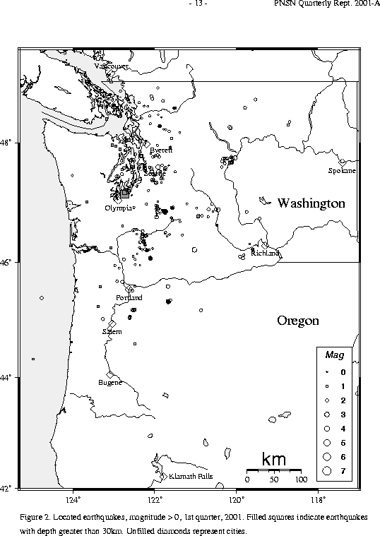
There were 1,174 events digitally recorded and processed at the University of Washington between January 1 and March 31, 2001. Locations in Washington, Oregon, or southernmost British Columbia were determined for 628 of these events; 509 were classified as earthquakes and 119 as known or suspected blasts. The remaining 546 processed events include teleseisms (153 events), regional events outside the PNSN (58), and unlocated events within the PNSN. Unlocated events within the PNSN include very small earthquakes and some known blasts. Frequent mining blasts occur near Centralia, Washington and we routinely locate some of them.
    DATE-(UTC)-TIME   LAT(N) LON(W)  DEPTH   MAG  COMMENTS					CIIM	 SHAKEMAP
  yy/mm/dd hh:mm:ss   deg.   deg.    km

01/02/14 03:54:54   48.76  123.12   20.9  2.3   26.0 km NNW of Friday Harbor, WA
01/02/14 22:03:58   47.52N  121.89W    6.6  3.1   5.3 km S of Fall City, WA                    x          x
01/02/24 07:40:50   47.54N  122.07W   22.6  2.2   13.2 km SE of Bellevue, WA
01/02/28 07:16:13   47.75N  120.04W    0.6  3.2   10.0 km S of Chelan, WA                      x
01/02/28 18:54:32   47.16N  122.73W   51.9  6.8   17.6 km NE of Olympia, WA                    x          x
01/03/01 09:10:20   47.21N  122.72W   54.3  3.4   22.3 km NE of Olympia, WA                    x
01/03/01 14:23:34   47.19N  122.74W   51.4  2.7   19.4 km NE of Olympia, WA
01/03/10 06:26:05   47.49N  122.81W   19.3  1.7   15.9 km SW of Bremerton, WA
01/03/11 17:08:54   47.60N  121.93W   21.6  2.9   4.4 km NNW of Fall City, WA
01/03/16 02:41:11   47.57N  122.09W   18.2  2.2   10.2 km ESE of Bellevue, WA
01/03/21 10:31:05   46.22N  121.03W    0.9  2.9   35.8 km E of Mt. Adams, WA
    DATE-(UTC)-TIME   LAT(N) LON(W)  DEPTH   MAG  COMMENTS		       strike dip  rake
  yy/mm/dd hh:mm:ss   deg.   deg.    km

01/01/24 18/47/39  48.26N   120.16W    0.6   2.8  44.6 km WSW of Okanogan, WA   35   30    100
01/02/14 22/03/58  47.52N   121.90W    6.6   3.1   5.4 km   S of Fall City, WA  50   55     60
01/02/28 07/16/13  47.75N   120.03W    0.6   3.2  10.2 km   S of Chelan, WA    275   90     90
                                                                                85   90     90
01/02/28 18/54/32  47.15N   122.73W   51.9   6.8  17.0 km  NE of Olympia, WA    15   70   -120
01/03/01 09/10/20  47.20N   122.71W   54.3   3.4  21.6 km  NE of Olympia, WA    20   70    -80
01/03/01 14/23/34  47.18N   122.73W   51.4   2.7  19.4 km  NE of Olympia, WA    30   70    -90
01/03/11 17/08/54  47.60N   121.92W   21.6   2.9   4.4 km NNW of Fall City, WA  20   60     50
01/03/17 19/55/47  46.07N   122.10W    6.1   2.5  16.0 km SSE of Mt St Hel., WA340   25   -100
                                                                               205   70    -70
01/03/21 10/31/05  46.21N   121.03W    0.9   2.9  35.4 km   E of Mt Adams, WA   50   50     50
    DATE-(UTC)-TIME   LAT(N) LON(W)  DEPTH   MAG  COMMENTS
  yy/mm/dd hh:mm:ss   deg.   deg.    km

01/02/28 18:54:32   47.14  122.72   51.9  6.8   MAINSHOCK   17.0 km  NE of Olympia, WA
01/02/28 19:02:03   47.18  122.72   52.3  1.0               19.7 km  NE of Olympia, WA
01/03/01 09:10:20   47.19  122.71   54.3  3.4   FELT        21.6 km  NE of Olympia, WA
01/03/01 14:23:34   47.18  122.72   51.4  2.7   FELT        19.4 km  NE of Olympia, WA
01/03/11 11:57:36   47.20  122.62   47.8  1.2               14.9 km WSW of Tacoma, WA
In the Klamath Falls area, only one earthquake occurred in the first quarter of 2001. Since 1994, most earthquakes in the Klamath Falls area have been considered aftershocks of a pair of damaging earthquakes in September of 1993. The 1993 earthquakes were followed by a vigorous aftershock sequence which decreased over time.
During the first quarter of 2001, 416 earthquakes were located between 45.5° and 49.5° north latitude and between 121° and 125.3° west longitude. Nine earthquakes were felt this quarter in western Washington. Details are in Table 3A. The 52 km deep, magnitude (Mw) 6.8 Nisqually earthquake on February 28, 2001 was the largest earthquake to occur in western Washington since 1949. The earthquake and its aftershocks are described in a special section of this report.
Other felt earthquakes this quarter include a M 2.3 earthquake on February 14, located about 26 km NNW of Friday Harbor, WA, and reported felt in Friday Harbor. Also on February 14, a M 3.1 felt earthquake occurred about 5.0 km S of Fall City, WA and was felt in Snoqualmie, Redmond, North Bend, Kirkland, Issaquah, Fall City, Duvall, and Carnation. On February 24 an earthquake located about 13 km SE of Bellevue, WA with a magnitude of 2.2 was reported felt in Bellevue and Kenmore.
Following the Nisqually earthquake, we received many felt reports for small earthquakes, either a result of heightened sensitivity of residents or a result of the public checking our website for recent earthquakes and then reporting them as felt. The first felt earthquake after the Nisqually earthquake and its aftershocks was a magnitude 1.7 which occurred on March 10 about 16 km SW of Bremerton, WA. This event was reported felt by residents in Port Orchard. On March 11, a magnitude 2.9 earthquake occurred about 4.0 km NNW of Fall City, WA and was felt by residents in North Bend. The last felt earthquake in western Washington for this quarter occurred on March 16 about 10km ESE of Bellevue, WA. The magnitude 2.2 earthquake was reported felt by residents in Redmond. Details are in Table 3.
The magnitude (Mw) 6.8 Nisqually earthquake occurred on February 28 at 1854 UTC (10:54 AM PST). It was located at a depth of 52 km beneath the Nisqually River delta about 18 km NE of Olympia, WA. The earthquake occurred in the eastward-dipping Wadati-Benioff zone within the subducting Juan de Fuca plate. This location was within 20 km of the magnitude 7.1 earthquake in 1949 and may have ruptured the same fault. A similarly deep subduction zone earthquake occurred in 1965 about 40 km northeast of the Nisqually earthquake with a magnitude of 6.5.
Special Web Pages on the Nisqually Earthquake can be found at:
A magnitude estimate of 6.7 was determined within only a few moments of the earthquake by a brand-new earthworm module called localmag. This program was still in the process of being tested and calibrated. Therefore, we were not confident in releasing that magnitude. Instead we released, along with the verified solution, a magnitude of 6.2 within 50 minutes after the earthquake. This 6.2 magnitude was reported to us by the West Coast- Alaska Tsunami Warning Center. Within three hours after the earthquake, the magnitude was revised to Mw=6.8 after consultation with the NEIC.
Updated information was provided all day following the earthquake. Many interviews with the local media were given and the staff and students handled the phone lines, responding to calls from emergency managers, the media, and the public. Information about the earthquake was also available on the PNSN Web server (see additional details in outreach section). However, many computer users trying to connect experienced slow response time. In the days following the earthquake, we added many links to our "Nisqually Earthquake" page as we monitored requests for information from our web users, and learned of useful web resources provided by other organizations.
Strong Motion recording of the Nisqually Earthquake:
The PNSN had completed the installation of 22 new real-time, strong motion seismographs in the summer of 2000. In January 2001, our main Earthworm data acquisition and processing system had been upgraded to a new machine. Our Nisqually Strong Motion Information Page:
In January, the USGS/TriNet ShakeMap software was implemented and being run in test mode. These strong motion recordings were used to produce an instrumental intensity ShakeMap for the Nisqually Earthquake
We imported the code that produces ShakeMap web pages from the TriNet group in southern California during the last quarter of 2000, and finished the local implementation in January, 2001. We generated ShakeMap entries for a number of previous events; earthquakes in 1999 and 2000 with at least 10 strong motion records. The system was still being run in test mode when the Nisqually earthquake occurred on February 28 and, because of this, it took many hours to generate a valid ShakeMap for this event. Considerable help was received from the ShakeMap team in Pasade na and from staff of the National Strong Motion Program in Menlo Park. In the course of checking the results, some errors in our database of station calibration information were found and corrected. ShakeMap still does not properly take into account the unique attenuation relation for deep earthquakes in the Pacific Northwest nor does it yet run automatically from an automatic trigger.
Since fall of 2000, collection and storage of "felt" reports for the Pacific Northwest has been done by the USGS "Community Intensity Internet Map (CIIM). "Felt" reports are reports from people about how intense the shaking was. The CIIM map turns the "felt" reports into a numeric Intensity value, and shows average intensity by zip code. After the Nisqually earthquake, more than 10,000 responses were received within a few weeks.
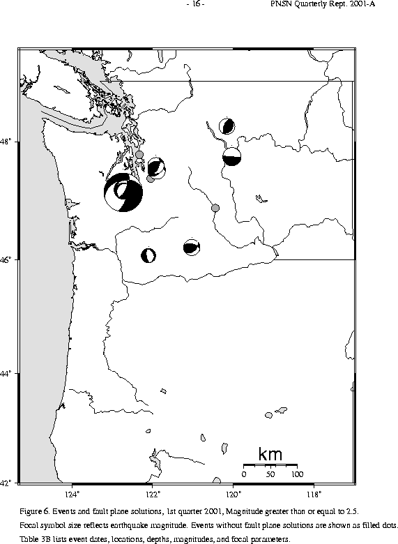
Aftershocks of the Nisqually Earthquake: The PNSN recorded four aftershocks in the two weeks following the Nisqually earthquake. The first aftershock, M 1.0, occurred within the coda of the main shock and was located about three km north of the mainshock. The two largest aftershocks, M 3.4, and 2.7, occurred in the early morning hours of the day after the mainshock, at 1:10 AM local time (M 3.4, located about six km north and slightly deeper than the main shock) and 6:23 AM local (M 2.7). Both events were felt, the larger one quite widely. The last aftershock, M 1.2, occurred twelve days after th e main shock. It was located about 13 km to the east-northeast of and four km shallower than the main shock. Details are given in Table 3C.
Focal Mechanism of the Nisqually Earthquake:
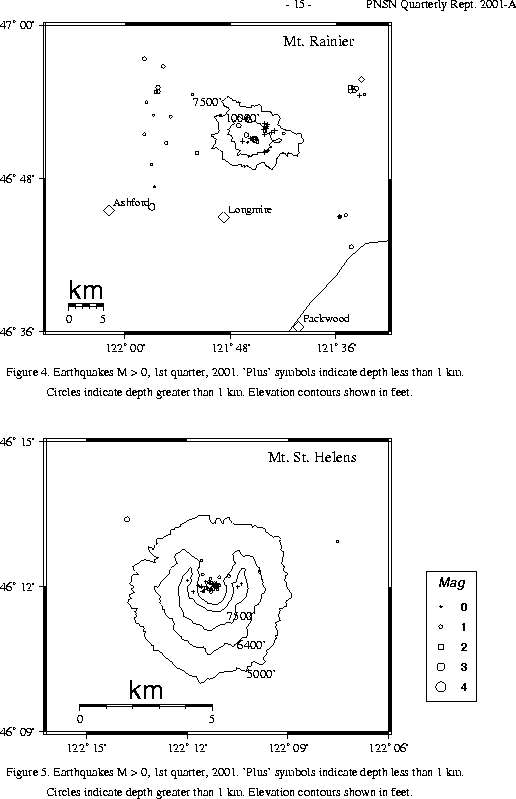
A total of 75 tectonic events (27 of these were smaller than magnitude 0.0, and thus are not shown in Fig. 4) were located within the region shown in Fig. 4. Of these, 22 were tectonic events located in the "Western Rainier Seismic Zone" (WRSZ), a north-south trending lineation of seismicity approximately 15 km west of the summit of Mt. Rainier (for counting purposes, the western zone is defined as 46.6-47 degrees north latitude and 121.83-122 west longitude). The largest tectonic earthquake located near Mt. Rainier this quarter was a magnitude 2.2 and was located about 0.5 km ESE of the summit at a depth of 1.5 km. This earthquake occurred on February 1, 2001.
This quarter, there were 29 (13 smaller than magnitude 0.0 and thus not shown in Fig. 4) higher-frequency tectonic-style earthquakes within 5 km of the summit. The remaining events were scattered around the cone of Rainier as seen in Fig. 4.
One type "S" or "L" event was located at Mount St. Helens, and 11 "L" or "S" events too small to locate were recorded.
During the first quarter of 2001, 53 earthquakes were located in eastern Washington in the area described in Table 4. Two felt earthquakes occurred in the first quarter of 2001 in eastern Washington. The first, M 3.2, was located 10 km S of Chelan, WA on February 28 UTC (February 27 PST), and was felt by residents in Chelan and Manson.
Some dubious felt reports were received for a very shallow M 2.9 earthquake located about 36 km E of Mt. Adams on March 21. This earthquake was in a remote area of the Yakima Indian Reservation, and n o felt reports were received from the nearby the event. However several felt reports, all from locat ions at considerable distance from the quake, were received via internet. Felt reports were received from Rock Island, Rainier, Enumclaw, Seattle, Bremerton, and Lynnwood although these locations are very far from the epicenter. Such improbable reports are likely due to nervousness and a heightened sensitivity to non-seismic vibrations following the Nisqually earthquake.
Times, locations, and depths of felt earthquakes in the PNSN region are given in Table 3A.