Information contained in this report is preliminary,
and should not be cited for publication.
Seismograph network operation in Washington and Oregon is supported by the state of Washington and the following contracts: U.S. Geological Survey Joint Operating Agreement 1434-HQ-98-AG-01937 and Contract 259116-A-B3 from the Pacific Northwest National Laboratory, operated by Battelle for the U.S. Dept. of Energy
There were 1,455 events digitally recorded and processed at the University of Washington between October 1 and December 31, 2000. Locations in Washington, Oregon, or southernmost British Columbia were determined for 863 of these events; 746 were classified as earthquakes and 117 as known or suspected blasts. The remaining 592 processed events include teleseisms (172 events), regional events outside the PNSN (65), and unlocated events within the PNSN. Unlocated events within the PNSN include very small earthquakes and some known blasts. Frequent mining blasts occur near Centralia, Washington and we routinely locate only some of them.
This quarter the PNSN imported ShakeMap from the Southern California TriNet project and began adapting it to our region. ShakeMap generates maps showing instrumentally measured shaking effects. During the quarter, two felt earthquakes larger than magnitude 3.0 occurred in the Puget Sound (on October 15 and Nov. 1) both were well recorded on the strong-motion network, and Shake Maps were made.
Last quarter the PNSN shifted the collection and storage of "felt" reports to the USGS "Community Intensity Internet Map (CIIM)". "Felt" reports are reports from people about how intense the shaking was. The CIIM m ap turns the "felt" reports into a numeric Intensity value, and shows average intensity by zip code. This quarter there were three earthquakes with enough felt reports to generate CIIM maps; the October 15 and Nov. 1 Puget Sound events mentioned above; and a third event near Entiat on Dec. 24.
  DATE-(UTC)-TIME   LAT(N) LON(W)  DEPTH   MAG  COMMENTS					CIIM	 SHAKEMAP
  yy/mm/dd hh:mm:ss   deg.   deg.    km

00/10/15 14:30:05    47.84N 123.00W  48.5   3.6   31.9 km WNW of Poulsbo, WA 		x  	x
00/11/01 08:37:17    48.27N 122.53W  21.8   3.3   21.6 km SW of Mount Vernon, WA 	x  	x
00/11/05 13:10:01    49.47N 119.63W   0.0   3.0   4.7 km  SW of Penticton, BC
00/11/10 09:12:39    48.45N 123.23W  25.2   2.5   9.5 km ENE of Victoria, BC
00/11/25 10:01:39    48.83N 119.33W   2.0   3.1   55.2 km NNE of Okanogan, WA
00/12/24 17:04:58    47.73N 120.28W   9.4   3.6   9.7 km NNW of Entiat, WA  		x
00/12/31 18:07:44    47.50N 121.67W  12.6   2.9   8.6 km E of North Bend, WA
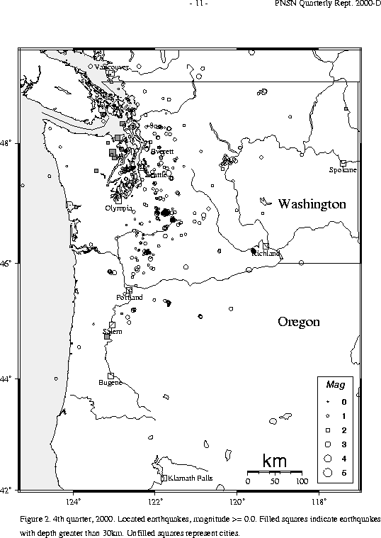
During the fourth quarter of 2000, 642 earthquakes were located between 45.5° and 49.5° north latitude and between 121° and 125.3° west longitude. Four earthquakes were felt this quarter in western Washington. Details are in Table 3.
The first felt earthquake was on October 15, located about 32 km WNW of Poulsbo, WA. The magnitude 3.6 earthquake was was well-recorded by our network of strong-motion instruments. The earthquake was felt across Kitsap and Jefferson counties, including the cities Poulsbo, Brinnon, Silverdale, Sequim, Bainbridge Island , and Mountlake Terrace.
On November 1 an earthquake was located about 21 km SW of Mount Vernon, WA with a magnitude of 3.3. This event was felt in areas around Whidbey Island, Camano Island, San Juan Islands, Stanwood, Marysville, and also Victoria, BC. It was well-recorded by our network of strong-motion instruments. The third felt earthquake this quarter occurred on November 10 and was actually located 10 km ENE of Victoria, BC. The PGC reported a magnitude of 2.5 and received felt reports across greater Victoria, BC. The last felt earthquake in western Washington for this quarter occurred on December 31 about 9 km E of North Bend, WA. The magnitude 2.9 earthquake was reported felt by several people in North Bend.
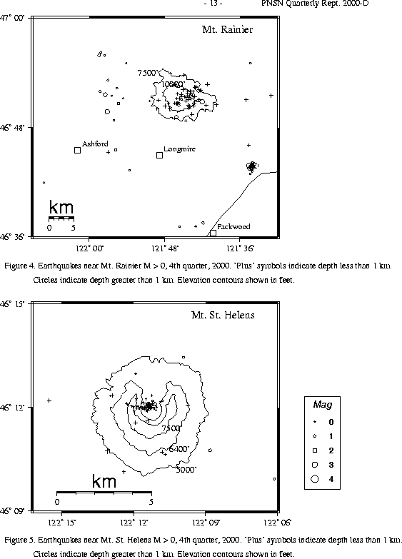
A total of 85 tectonic events (25 of these were smaller than magnitude 0.0, and thus are not shown in Fig. 4) were located within the region shown in Fig. 4. Of these, 31 were tectonic events located in the "Western Rainier Seismic Zone" (WRSZ), a north-south trending lineation of seismicity approximately 15 km west of the summit of Mt. Rainier (for counting purposes, the western zone is defined as 46.6-47 degrees north latitude and 121.83-122 west longitude). The largest tectonic earthquake located near Mt. Rainier this quarter was a magnitude 2.5 and was located about 20 km SE of Mt. Rainier at a depth of 3.7. This earthquake was one of 29 events in this area 20 km SE of Mt. Rainier that occurred between November 11 and November 22, 2000. The cluster of earthquakes began on November 11 with a magnitude 2.4 earthquake. The magnitudes ranged from -0.3 to 2.5, with 16 events having a magnitude >= 1.0. This cluster can be seen in Fig. 4.
This quarter, there were 20 higher-frequency tectonic-style earthquakes within 5 km of the summit. The remaining events were scattered around the cone of Rainier as seen in Fig. 4.
Three type "S" or "L" event were located at Mount St. Helens, and 65 "L" or "S" events too small to locate were recorded.
During the fourth quarter of 2000, 73 earthquakes were located in eastern Washington. The fourth quarter of 2000 presented some interesting seismicity in eastern Washington: A small cluster of earthquakes, visible in Fig. 2, began on December 21, 2000 about 18 miles west of the Tri-Cities (Richland, Pasco, and Kennewick, WA). The epicenters are near the north end of the Horse Heaven Hills, 8 miles east of Prosser and 25 km WSW of Richland. The cluster occurred between December 12, 2000 through December 18, 2000, and included 28 located earthquakes with magnitudes between -0.5 and 2.1. Earthquakes in this part of the Columbia Plateau are common and often occur in swarms. More than 90 percent of swarm earthquakes near the Tri-Cities region are very shallow, at less than 8 km depth. However, the depths of this quarter's swarm are 8-10 km below the surface. Focal mechanisms of Columbia Plateau earthquakes usually indicate a north-south compressive thrust regime perpendicular to, and consistent with, the east-west trend of the anticlines of the Yakima fold belt. This quarter's earthquakes occur within a NE trending zone of earthquakes in the Horse Heaven Hills. However, the mechanisms of the earthquakes in the current cluster determined by P-wave first motions, and the spatial pattern of the hypocenter locations suggest that the earthquakes are occurring on a fault perpendicular to this trend, possibly on a northwest striking reverse fault.
The other interesting seismicity in eastern Washington were two felt earthquakes. The first was located 55 km north-northeast of Okanogan, WA. The magnitude 3.1 earthquake was reported felt by residents living 50 miles north of Okanogan. The second felt earthquake occurred near Entiat, WA. The magnitude 3.6 earthquake occurred on December 24, 2000 at 1705 UTC time. It was located about 10 km north-northwest of Entiat at a depth of about 9 km. The felt reports included areas around Entiat, Wenatchee, and Chelan. This area is a very persistent temporal and spatial cluster of earthquake activity. Instrumental coverage was not very good in the Chelan cluster area until around 1976. Since 1976, the rate of seismicity has been quite steady, with between 27 and 69 earthquakes of magnitude 1.0 or larger each year. An earthquake occurred on November 5 in Penticton, B.C. The PGC reported a magnitude 2.6 and received reports that it was felt in the Penticton area.
Times, locations, and depths of felt earthquakes in the PNSN region are given in Table 3.