Information contained in this report is preliminary,
and should not be cited for publication.
Seismograph network operation in Washington and Oregon is supported by the state of Washington and the following contracts: U.S. Geological Survey Joint Operating Agreement 1434-HQ-98-AG-01937 and Contract 259116-A-B3 from the Pacific Northwest National Laboratory, operated by Battelle for the U.S. Dept. of Energy
Felt Earthquakes during the 2nd Quarter of 2000
  DATE-(UTC)-TIME   LAT(N) LON(W)  DEPTH   MAG  COMMENTS
  yy/mm/dd hh:mm:ss   deg.   deg.    km
00/04/11 09:09:03  48.40N 122.27W  14.4   3.2   5.2 km ESE of Mount Vernon, WA
00/04/22 06:43:25  46.86N 121.97W   8.8   3.6  16.5 km   W of Mount Rainier
00/06/29 19:27:26  48.46N 123.10W  27.6   3.5  10.6 km  SW of Friday Harbor, WA
There were 1191 events digitally recorded and processed at the University of Washington between April 1 and June 30, 2000. Locations in Washington, Oregon, or southernmost British Columbia were determined for 513 of these events; 447 were classified as earthquakes and 66 as known or suspected blasts. The remaining 678 processed events include teleseisms (183 events), regional events outside the PNSN (114), and unlocated events within the PNSN. Unlocated events within the PNSN include very small earthquakes and some known blasts. Frequent mining blasts occur near Centralia, Washington and we routinely locate and retrieve broad-band data for some of them.
The most interesting activity in Oregon this quarter was a swarm of earthquakes near Mt. Hood. The sequence began on May 14 with a magnitude 2.1 earthquake, at a depth of about 7 km. This was followed by 21 similarly shallow quakes between May 14 (10 events on May 14) and May 26. No events were reported felt in Oregon this quarter.
In the Klamath Falls area, 15 earthquakes were located this quarter. Since 1994, most earthquakes northwest of Klamath Falls have been considered aftershocks of a pair of damaging earthquakes in September of \fI1993\fR (Sept. 21, 03:29 and 05:45 UTC; Mc 5.9 and 6.0 respectively). The 1993 earthquakes were followed by a vigorous aftershock sequence which decreased over time.
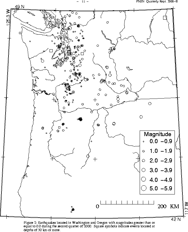
During the second quarter of 2000, 338 earthquakes were located between 45.5°-49.5° north latitude and 121°-125.3° west longitude.
Three earthquakes were felt this quarter in western Washington, The largest was an a magnitude 3.6 earthquake in the "Western Rainier Seismic Zone" on April 22. Details are given in Table 3. The felt event was preceded by a possible foreshock (M 0.2) on April 20, and followed by three small aftershocks on April 22 (Magnitudes 1.2, -0.3 and -0.5).
This quarter, the deepest event recorded by the PNSN was a magnitude 2.0 at a depth of about 89 km. It occurred on June 2 at 05:44 UTC and was located about 13 km ENE of North Bend, WA.
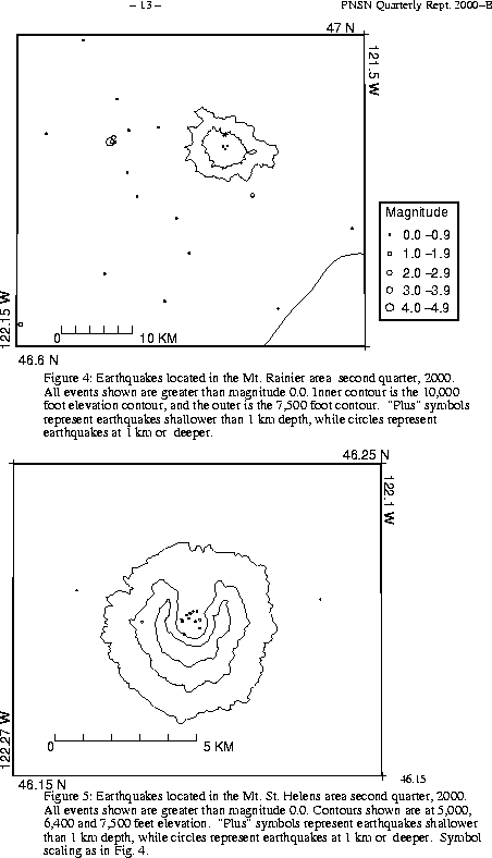
A total of 51 tectonic events (22 of these were smaller than magnitude 0.0, and thus are not shown in Fig. 4) were located within the region shown in Fig. 4. Of these, 23 were located in the "Western Rainier Seismic Zone" (WRSZ), a north-south trending lineation of seismicity approximately 15 km west of the summit of Mt. Rainier (for counting purposes, the western zone is defined as 46.6-47 degrees north latitude and 121.83-122 west longitude). The largest tectonic earthquakes near Mt. Rainier this quarter was the felt magnitude 3.6 earthquake on April 22 (UTC) mentioned above.
This quarter, there were 14 higher-frequency tectonic-style earthquake within 5 km of the summit. The remaining events were scattered around the cone of Rainier as seen in Fig. 4.
Two type "S" or "L" event were located at Mount St. Helens, and 94 "L" or "S" events too small to locate were recorded.
During the second quarter of 2000, 44 earthquakes were located in eastern Washington in the area described in Table 4. The largest earthquake in eastern Washington this quarter was a poorly located magnitude 3.3 earthquake about 40 km east north-east of Colville.
Times, locations, and depths of felt earthquakes in the PNSN region are given in Table 3.