	WASHINGTON AND OREGON
(120th MERIDIAN OR PACIFIC STANDARD TIME)

January 25: 17:16:06*. Epicenter 48 degrees 20' north, 122 degrees 26' west, near mouth of Skagit River,
	S. Felt over an area of approximately 15,000 square miles of northwestern Washington. (See
	map, p. 36.) Maximum intensity (damage) VI was reported from one location, Clearlake, where
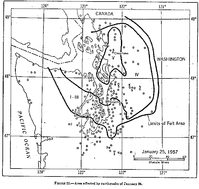
	plaster cracked and fell on second floor of school; knickknack shelf shifted; felt by many and
	frightened few. Lights swayed in barber shop and barber was forced to stop cutting hair until
	vibrations ceased.
    INTENSITY (DAMAGE) V: Acme, Anacortes, Arlington, Bothell, Bow,  Burlington,  Chimacum,
	Clinton, Clipper, Deming, Friday Harbor, Granite Falls, Greenbank (Sec. 8, T30N, R2E), Had-
	lock, Index, Langley, Lowell, Lummi Island, Port Gamble, Port Ludlow, Seabold, Seattle, Sedro
	Woolley, Silvana, Snohomish, Stanwood and 5 miles east of, Startup, Sultan, and Wickersham.
    INTENSITY (DAMAGE) IV: Alderton, Alderwood Manor, Allyn (Sherwood  Creek),  Baring,
	Bellingham, Blanchard, Bremerton, Carlsborg, Carnation, Centralia, Concrete, Coupeville, Dar-
	rington, Decatur Island, Deer Harbor, Duvall, Eastsound, Edison, Everett, Everson, Fall City,
	Fortson, Freeland, Glacier, Gold Bar, Hamilton, Hansville, Harper, Hoodsport, Kenmore, Kitsap,
	La Conner, Lakewood, Leland, Lopez, Lynwood, Marblemount, Marietta, Marysville, Mount Ver-
	non, Mukilteo, Nordland, North Bend and North Bend Ranger Station, Oak Harbor, Orcas, Oso,
	Port Angeles and North Olympic Peninsula, Port Orchard, Port Townsend, Preston, Quilcene,
	Richmond Beach, Seattle Heights, Selleck, Skykomish, Snoqualmie and  ,Meadowbrook,  Sumas,
	Suquamish, Tacoma, Waldron, and Woodinville.
    INTENSITY (DAMAGE) I TO III: Aberdeen, Blaine,  Brinnon,  Cedar  Falls,  Cushman  Dam
	(Hoodsport), Custer, Edmonds, Elbe, Ferndale, Graham (Davis Road), Hyak, Joyce,  Kennydale,
	Kent, Keyport, La Grande, Lilliwaup, Longbranch, Lost Lake (10 miles west of Shelton), Lynden,
	Maltby, Mercer Island, Monroe, Nisqually, Nooksack, Nooksack Falls Powerhouse, Olalla, Olga,
	Orillia, Orting, Pacific, Portage, Puyallup, Redmond, Retsil, Rockport, Rollingbay, Seabeck, Shaw
	Island, Shelton, Van Zandt, and Wauna. Also felt at Ladner, B. C.
February 11: 09:04:57*. Epicenter 47 degrees 32' north, 121 degrees 04' west, near North Bend, S. Felt
	over an area of approximately 4,000 square miles of northwestern Washington. Maximum
	intensity (damage) VI.

    INTENSITY (DAMAGE) VI:
      Fall City.-Felt by all; frightened few. Chimney cracked. Small objects and furnishings
	shifted; knickknacks fell.
      North Bend Ranger, Station (North Bend).-Felt by several. Eight-inch plasterboard
	crack. Windows, doors, and dishes rattled slightly; house creaked. Felt by many at North Bend
	(some outdoors; active) ; awakened and frightened few.
      Snoqualmie.-Felt by many (by observer; active). Plaster cracked. Dishes rattled; walls
	creaked.
    INTENSITY (DAMAGE) V: Issaquah, Preston, Redmond, Snoqualmie Falls, and Snoqualmie
	Falls Tree Farm (near Black Lake).
    INTENSITY (DAMAGE) IV: Bothell, Carnation, Cedar Falls and Cedar Falls Power Station
	Camp, Gold Bar, Kenmore, Kennydale, Orillia, Port Gamble, Renton, Seahurst, Seattle and
	Seattle-Tacoma Airport (15 miles south of Seattle), and Selleck.
    INTENSITY (DAMAGE) I TO III: Bellevue, Cumberland, Dash Point, Dockton, Eatonville,
	Gorst, Houghton, Langley, Maltby, Mercer Island, Mukilteo, Pacific, Port Blakely, Poulsbo,
	Redondo, Seabeck, Skykomish, Sultan, Summer, Tracyton (2 miles north of), Vashon, and
	Woodinville.
March 14: 03:16. Bellingham, Washington area, S. IV. Distinctly felt by many in the
	Lake Sammish, Lake Whatcomb, and southern suburban areas of Bellingham.
    March 22: 16:00. Alsea, Oreg. Two light tremors felt.
May 4: 13:09:25*. Epicenter 47 degrees 21' north, 122 degrees 23' west, Puget Sound, near Dash Point, S.
	Felt over an area of approximately 2,000 square miles of western Washington. Maximum inten-
	sity (damage) V.
    INTENSITY (DAMAGE) V:
      Algona.-Felt by and frightened many in community; awakened few. Small objects shifted.
      Auburn.-Chair moved back and forth about 2 inches. Motion reported as quite violent.
	Observer immediately left modern concrete building. Felt like a sharp, up-and-down movement
	to another person, who became slightly nauseated. Windows rattled; walls creaked.
      Buckley.-Felt by all. Windows, doors, and dishes rattled.
      Des Moines.-Felt by all.
      Redondo.-Felt by several. Small objects shifted. Windows rattled.
      Sumner-.-Felt by and frightened many. Trees, bushes shaken moderately.
      Zenith.-Felt by all.
    INTENSITY (DAMAGE) IV: Alderton, Bremerton, Burien, Burley, Burton, Cove, Dash Point,
	Dockton, Fox Island, Gorst, Manchester, McMillin, Milton, Oakville, Olalla, Olympia, Orting, Port
	Orchard, Puyallup, Roy, South Colby, Southworth, Spanaway, Tacoma,  Tracyton,  Tumwater,
	Wauna, and Yoman.
    INTENSITY (DAMAGE) I TO III: Belfair, Carbonado, Cedar Falls, Dieringer, Eatonville, Fort
	Steilacoom, Gig Harbor, Harper, Kennydale, Lakebay, Lakeview, North Bend, Orillia, Portage,
	Seabeck, Seahurst, and Seattle.
May 29: 02:46 and 03:15. Hoodsport, Wash. (Lake Cushman, Cushman Power Plant No. 1),
	S. IV. Felt by several at power plant; awakened few in home and community.
July 7: 09:23. North Bend, Wash., S. IV. Felt by several. Walls creaked. Lasted 10
	seconds; direction northeast-southwest.
October 29: 07:30. Eatonville and Selby, Wash., S. IV. At Eatonville some persons left
	their beds and went outdoors to find out what had happened. Reported as having about the same
	intensity as the shock of November 1 at 02:12:00*. At Elbe, many felt the shock, which was
	accompanied by a rumbling noise.
November 1: 02:12:00". Epicenter 47 degrees north, 121 degrees west, near Mount Rainier, W. Felt
	over an area of approximately 1,500 square miles of southwestern Washington, principally in
	Pierce and Lewis counties. Maximum intensity (damage) V.
    INTENSITY (DAMAGE) V:
      Longmire.-Felt by and awakened many in community. Windows rattled; walls creaked.
      Packwood.-Awakened all and frightened few in community. Windows rattled; houses shaken.
      Regarded as strong shock by everyone. Two slight shocks felt about 10-15 minutes
	after the first; one moderately heavy shock felt about 30-40 minutes after first shock.
      Randle.-Strong shock. Felt by and awakened  many  in  community;  frightened  few.
	Windows, doors, and dishes rattled; trees, bushes shaken slightly. Two light aftershocks felt.
    INTENSITY (DAMAGE) IV: Ashford, Eatonville, Elbe, Enumclaw, and Morton.
    INTENSITY (DAMAGE) I TO III: Baldi (8 miles east of Palmer), Granite Falls and 2 miles
	south of, Rille (25 miles east of), and Seattle.
November 16: 22:00:29*. Epicenter 45.3 degrees north, 123.8 degrees west, northwest of Salem, B. Felt
	over a land area of approximately 4,500 square miles of northwestern Oregon. (See map, p.
	38.)   Maximum intensity (damage) VI at Salem. Damage slight.
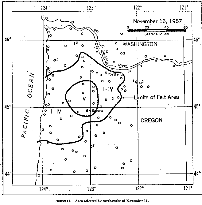
    INTENSITY (DAMAGE) VI:
      Salem.-Frightened all. Plaster and walls cracked in West Salem. Furnishings shifted.
	In the northeast section, pictures and lamps rattled; whole house rumbled. Woman lying on sofa
	said sofa "began to move across room." TV temporarily blacked out and other momentary out-
	ages reported. Some persons reported the motion seemed like a single, sharp, blastlike jolt,
	while others said the vibrations lasted for several seconds.
    INTENSITY (DAMAGE) V: Dallas, Newberg, Otis, Willamina, and Yamhill.
    INTENSITY (DAMAGE) IV: Aloha, Aumsville, Beaver, Boring, Brooks, Cherry Grove, Clover-
	dale, Corvallis, Dundee, Falls City, Grande Ronde, Harlan, Kernville (7 miles up river), McMinn-
	ville, Molalla, Pacific City, Portland, Sherwood, Siletz, Tillamook, Toledo (4 miles cast of), and
	Valsetz.
    INTENSITY (DAMAGE) I TO III: Birkenfeld, Brightwood, Brownsville, Buxton, Colton, Gales
	Creek, Hood River, Monmouth, Nehalem, Oceanside, Silverton, Taft, Woodburn, and Zigzag.
    INTENSITY (DAMAGE) I TO III IN WASHINGTON: Yacolt (about 7 miles southeast of, Dole
	Valley).
UW Dept. of Earth and Space Sciences ..... . PNW EARTHQUAKES