
Bremerton Earthquake Intensity Map
The following map is an attempt to display the
felt-form data obtained by our Web forms responses.
This map was generated by
averaging the responses over all responses from one zip-code
and using that average at the geographic center of the zip code (dots
on the map) and then producing a smooth contour of those values. We plan
to try and do a similar thing for the exact location of each
response; however, it is quite difficult to obtain a geographic
coordinate from a full address so this may take much longer.
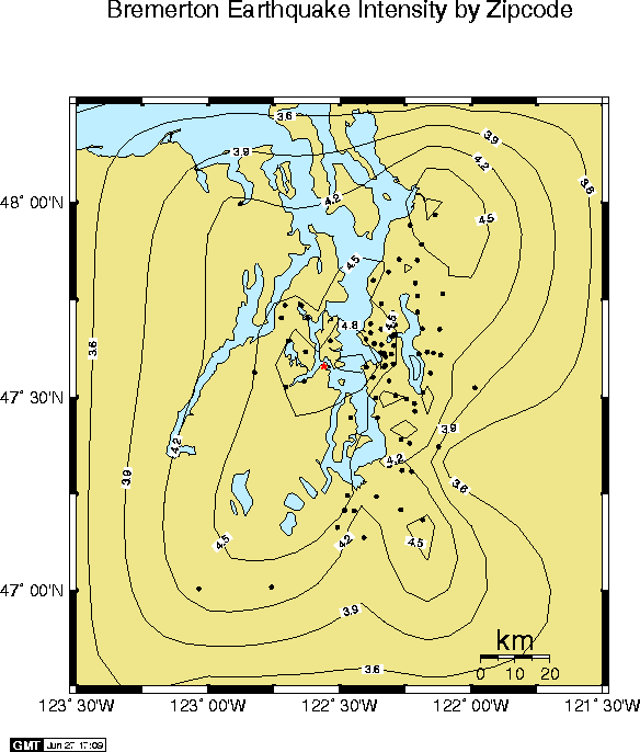
About the isoseismal map:
The contours shown on this map represent equal strength of shaking and
are known as isoseismal lines. The numbers (ranging from 3.3 to 5) are
intensity values and should not be confused with earthquake magnitude.
Earthquake magnitude is a measure of the relative size of the earthquake
source and can be determined from seismographs often located far from the
earthquake epicenter. In theory, each earthquake will have a single
magnitude value. In practice, different ways of calculating magnitude
and the use of different seismic instruments will cause some
variation in
the magnitude numbers. However, these
variations are usually pretty small and the final magnitude
calculations for the Bremerton earthquake all fall between 4.2 and 5.0.
Earthquake intensities, in contrast to magnitude, always show
considerable variation. The intensity is usually strongest near the
earthquake epicenter and decreases with distance until eventually, at
some point far away, the earthquake is no longer felt by anyone. Other
factors such as the local geology beneath a particular site, the regional
geology and the orientation of the earthquake fault can all affect
intensities. Intensities are determined from the reports of individuals and
assessments of damage caused by the earthquake. The numbers on the map
represent relative shaking strength and can by qualitatively
interpreted as follows:
- less than 3.5: Weak. Not felt or weakly felt.
- 3.5 - 4.4: Mild. Felt by most people inside, no items knocked off shelves
no damage, few people frightened.
- 4.5 - 5.4: Moderate. Felt by almost everyone inside and many outside,
occasional reports of a few objects toppled over or knocked off shelves,
no damage, some people frightened, some people run out of buildings
- 5.5 - 6.4: Strong. Felt be everyone inside and most outside, awakens all
sleepers. Most people report some items knocked from shelves. A few
reports of minor damage like cracks in plaster, occasional broken windows.
Many are frightened.
Some individual reports were for shaking stronger than this; however the
map shows averages over a zip-code district and so will not represent
the worst shaking in an area.
Although there are no higher averages on the Bremerton map, other earthquakes are
quite capable of producing stronger shaking. Higher values have the
following general characteristics:
- 6.5 - 7.4: Severe. Felt by all, awakens all, felt by persons driving
cars, heavy furniture displaced, many reports of minor damage, major
damage rare. Most people are frightened.
- 7.5 - 8.4: Violent. Major damage to poorly built structures such a
unreinforced masonry buildings. Houses likely to move off foundations if
not secured. Anything not firmly secured will be displaced including
water heaters, wood burning stoves, pianos etc.
- 8.5 - 9.4: Extreme. Damage to some structures designed to resist strong
ground shaking. This is the intensity level experienced in the communities of
Northridge, Grenada Hills and Sherman Oaks from the 1994 Northridge
earthquake.
Descriptive text adapted from report by Lori Dengler
of Humbolt State University
Back to:...
UW Dept. of Earth and Space Sciences ..... PNW EARTHQUAKES
University of Washington Dept. of Earth and Space Sciences, Box 351310 Seattle, WA, 98195-1310
This is file /SEIS/EQ_Special/WEBDIR_97062319131p/intensity.map.html;
modified 6/27/97 - If you see any problems e-mail: seis_web@ess.washington.edu