| Magnitude | 3.4 |
|---|---|
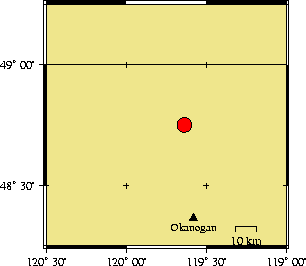
| Time | Friday December 26, 2003 at 10:07:45.65 Z (UTC) Friday December 26, 2003 at 02:07:45.65 AM (PST) | Distance from | 43.2 km N of Okanogan, WA 83.3 km S of Penticton, BC 204.5 km NW of Spokane, WA (Mission & N Division) |
| Coordinates | 48.753 deg N 119.635 deg W |
| Depth | 0 km |
| Quality | poor (DD) |
| Note: 1 km = 0.621 mile or 1 mile = 1.61 km | |