Information contained in this report is preliminary,
and should not be cited for publication.
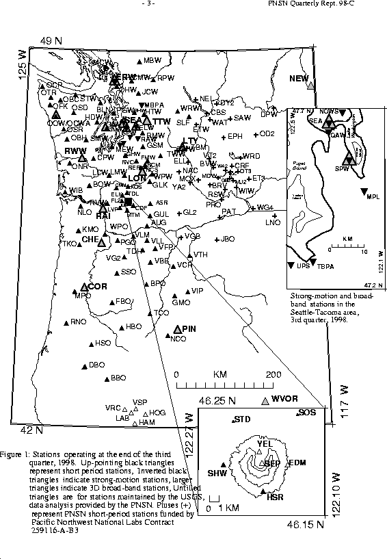
Seismograph network operation in Washington and Oregon is supported by the state of Washington and the following contracts: U.S. Geological Survey Joint Operating Agreement 1434-HQ-98-AG-01937 and Contract 259116-A-B3 from the Pacific Northwest National Laboratory, operated by Battelle for the U.S. Dept. of Energy
Felt Earthquakes during the 3rd Quarter of 1998
  DATE-(UTC)-TIME    LAT(N) LON(W) DEPTH MAG COMMENTS
  yy/mm/dd hh:mm:ss   deg.   deg.    km
NO EARTHQUAKES WERE REPORTED FELT DURING THE THIRD QUARTER OF 1998
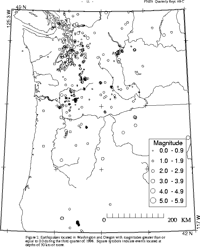
There were 2,963 events digitally recorded and processed at the University of Washington between July 1 and September 30, 1998. Locations in Washington, Oregon, or southernmost British Columbia were determined for 1,727 of these events; 1,635 were classified as earthquakes and 92 as known or suspected blasts. The remaining 1,236 processed events include teleseisms (195 events), regional events outside the PNSN (93), and unlocated events within the PNSN. Unlocated events within the PNSN include very small earthquakes and some known blasts. Frequent mining blasts occur near Centralia, and we routinely locate and retrieve broad-band data for some of them.
In the Klamath Falls area, 51 events were located this quarter. Most earthquakes in the Klamath Falls are aftershocks of a pair of damaging earthquakes in September of \fI1993\fR (Sept. 21, 03:29 and 05:45 UTC; @ M sub c @ 5.9 and 6.0 respectively). These earthquakes were followed by a vigorous aftershock sequence which has decreased over time.
During the third quarter of 1998, 1,463 earthquakes were located between
45.5°-49.5° north latitude and
121°-125.3° west longitude.
This quarter, there were no events in western Washington deeper than 50 km.
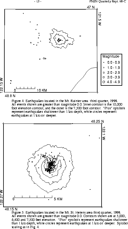
Figure 4 shows earthquakes near Mount Rainier. The number of events in close proximity to the cone of Mt. Rainier varies over the course of the year, since the source of much of the shallow surface-type activity is presumably ice movement or avalanching, which is seasonal in nature. Events with very low frequency signals (1-3 Hz) believed to be icequakes are assigned type "L" in the catalog. Emergent, very long duration signals probably due to rockfalls or avalanches are assigned type "S" (see Key to Earthquake Catalog). "L" and "S" type events are listed in the catalog, but not shown in Figure 4. Although only four events flagged "L" or "S" events were located at Rainier this quarter, 153 additional "L" or "S" events there were too small to l ocate.
A total of 76 events (11 were smaller than magnitude 0.0, and thus are not shown in Fig. 4) were located within the region shown in Fig. 4. Of these, 24 were located in the "Western Rainier Seismic Zone" (WRSZ), a north- south trending lineation of seismicity approximately 15 km west of the summit of Mt. Rainier (for counting purposes, the western zone is defined as 46.6-47 degrees north latitude and 121.83-122 west longitude). The largest tectonic earthquake this quarter was magnitude 2.5.
This quarter, there were 40 higher-frequency, tectonic-style earthquakes within 5 km of the summit. The remaining events were scattered around the cone of Rainier as seen in Fig. 4.
Although only six type "S" or "L" events were located at Mount St. Helens, 565 "S" events too small to locate were recorded.
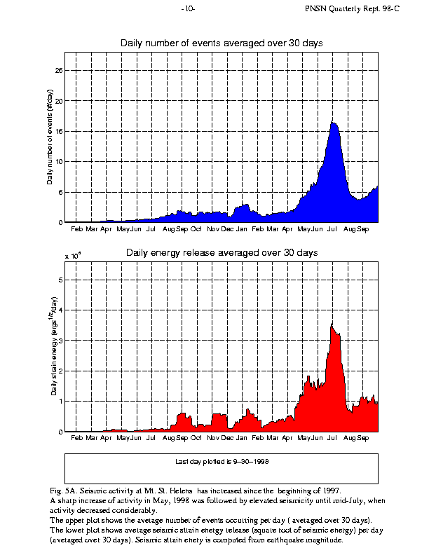
Figure 5A shows plots that demonstrate how seismicity at Mt. St. Helens has varied since the beginning of 1997. The top part of Fig. 5A shows the daily number of earthquakes, while the lower part indicates daily energy levels. The total number of events and daily energy level rose slightly in 1997 .
In May of 1998, activity at Mt. St. Helens increased rapidly. Elevated activity continued through June and the early part of July, and then dropped back to a lower, yet still slightly elevated, level. Information statements were issued on June 2, July 1, and August 14, 1998:
During the third quarter of 1998, 84 earthquakes were located in eastern Washington between 45.5-49.5 degrees north latitude and 117-121 degrees west longitude.. The largest earthquake recorded this quarter near the eastern Washington part of the PNSN network was a magnitude 3.1 event on July 21 (UTC), 58 km ENE of Baker, OR. A magnitude 3.0 earthquake had occurred nearby on the preceding day. Neither event was reported felt.
Times, locations, and depths of felt earthquakes are usually given in Table 4, but no felt events were reported this quarter.