Information contained in this report is preliminary,
and should not be cited for publication.
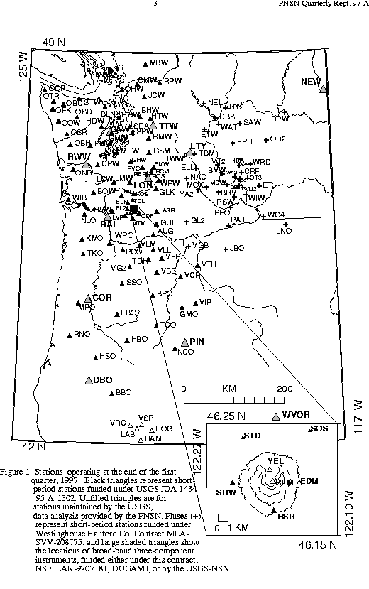
Seismograph network operation in Washington and Oregon is supported by the state of Washington and the following contracts: U.S. Geological Survey Joint Operating Agreement 1434-95-A-1302 and Contract 259116-A-B3 from the Pacific Northwest National Laboratory, operated by Battelle for the U.S. Dept. of Energy
 1.  97/05/03 23:49:44  48.48N 121.70W   0.0 3.1   6.3 km SSE of Concrete
 2.  97/05/18 08:28:08  48.66N 122.35W  12.7 3.2  14.2 km  SE of Bellingham
 3.  97/05/22 10:35:21  44.05N 122.51W   6.8 2.3  45.6 km   E of Eugene, OR
 4.  97/05/22 13:57:10  44.05N 122.51W   8.1 2.6  45.4 km   E of Eugene, OR
 5.  97/06/13 13:44:37  49.23N 123.56W  25.7 3.1  40.0 km WNW of Vancouver,BC
 6.  97/06/14 20:18:07  48.11N 121.58W  12.0 2.6  14.6 km   S of Darrington
 7.  97/06/23 19:13:27  47.58N 122.56W   7.2 4.9   5.7 km  NE of Bremerton
 8.  97/06/23 19:30:09  47.60N 122.55W   1.2 2.6   6.9 km  NE of Bremerton
 9.  97/06/23 21:46:24  47.60N 122.55W   0.9 3.1   6.9 km  NE of Bremerton
 10. 97/06/24 14:23:13  48.35N 119.88W  11.2 4.6  23.0 km   W of Okanogan
 11. 97/06/24 14:36:02  48.36N 119.88W   8.4 3.6  22.6 km   W of Okanogan
 12. 97/06/24 14:40:58  49.25N 123.61W  14.2 4.6  44.2 km WNW of Vancouver,BC
 13. 97/06/24 20:40:10  47.58N 122.55W   1.1 2.6   6.9 km ENE of Bremerton
 14. 97/06/26 07:11:04  47.60N 122.55W   0.3 1.2   7.0 km  NE of Bremerton
 15. 97/06/27 05:30:49  47.60N 122.58W   1.5 3.1   5.4 km  NE of Bremerton
 16. 97/06/27 10:47:49  47.58N 122.55W   0.9 3.9   6.9 km ENE of Bremerton
There were 951 events digitally recorded and processed at the University of Washington between April 1 and June 30, 1997. Locations in Washington, Oregon, or southernmost British Columbia were determined for 525 of these events; 473 were classified as earthquakes and 52 as known or suspected blasts. The remaining 426 processed events include teleseisms (127 events), regional events outside the PNSN (37), and unlocated events within the PNSN. Unlocated events within the PNSN include very small earthquakes and some known blasts. Frequent mining blasts occur near Centralia, and we routinely locate and retrieve broad-band data for some of them.
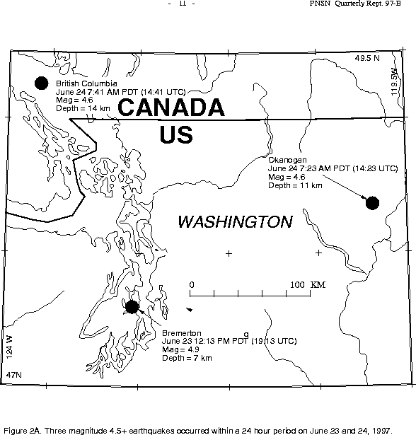
This quarter three earthquakes larger than magnitude 4.5 occurred within 24 hours. These earthquakes were widely distributed geographically. The first, and largest, earthquake occurred within the Puget basin near Bremerton. The second earthquake was east of the Cascade crest near Okanogan, and the third was located in British Columbia's Georgia Strait between Vancouver Island and the mainland. These earthquakes are shown in Figure 2A.
Bremerton earthquake, June 23 19:13 UTC, M 4.9
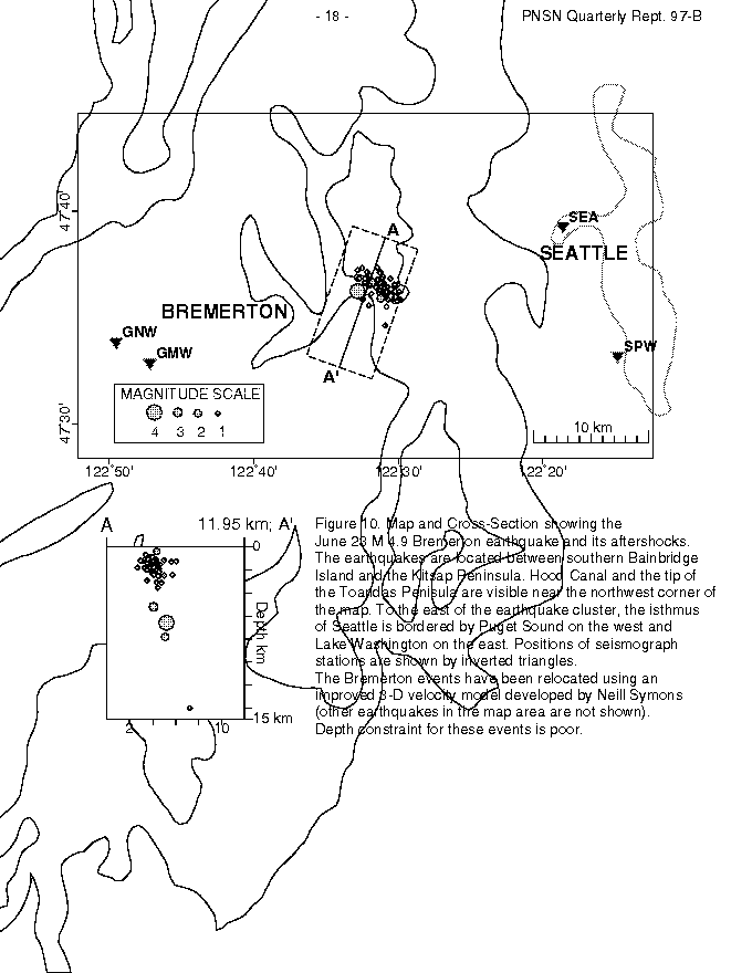
The largest earthquake within our network area this quarter was the magnitude 4.9 Bremerton earthquake on June 23, 1997 at 12:13PM PDT (19:13 UTC). The epicenter was approximately 5.7 km east-northeast of Bremerton, Washington. The earthquake, and several aftershocks, were widely felt throughout the greater Seattle area. Damage from this earthquake was limited to settling and minor structural damage (minor foundation or mortar cracking, doors that won't close properly, etc.) to about a dozen homes in Kitsap county. As of July 28th, a total of 65 earthquakes have been located in the immediate vicinity of the mainshock.
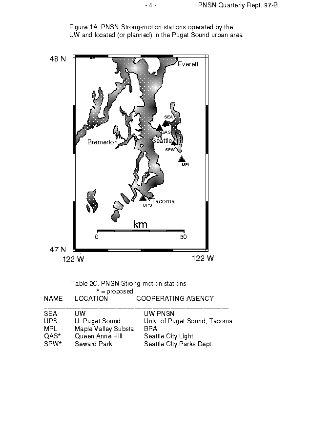
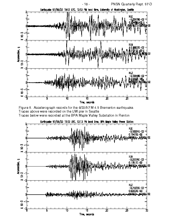
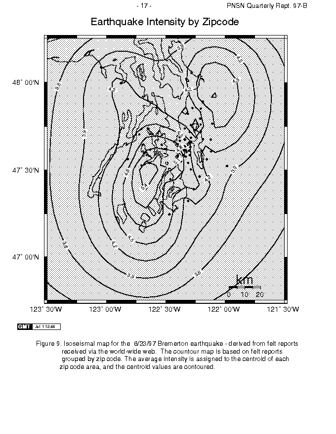
The M 4.9 June 23 Bremerton earthquake was the first event large enough to trigger the three currently installed stations of the PNSN strong-motion network (Figure 1A.). Preliminary peak ground accelerations were recovered at 3 strong motion sites and one broadband seismometer. Peak ground accelerations recorded range from 0.0015 g to 0.0023 g on the strong-motion accelerometers while the value at the broadband station (GNW) was 0.0095 g. Figure 8 shows two of the strong motion recordings. Figure 9 shows an Isoseismal map derived from reports received via the world-wide web. However, comparison of the station locations (Figure 1A.) to the Isoseismal map (Figure 9) shows that all of the strong motion stations are at the edge of the felt area while the broadband station is near the region that experienced the highest intensity of shaking.
Although none of the earthquake depths can be determined accurately due to the distribution of PNSN seismograph stations relative to the earthquake locations, Figure 10 shows improved locations determined with a 3-D velocity model developed by PhD. candidate Neill Symons. In map view the aftershocks seem to line up along the north dipping plane and in cross section the events appear to dip to the south. Focal mechanisms for the mainshock and aftershocks are consistent with predominantly thrust motion with a north-south compression axis.
Okanogan earthquake, June 24 14:12 UTC, M 4.6
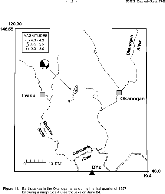
A magnitude 4.6 earthquake centered between Okanogan and Twisp, Washington, occurred at 14:40 UTC (6:40 am PST) on June 24, 1997. aftershocks. It had a depth of about 11 km, and was widely felt in eastern Washington, with only minor reports of damage (including some furniture shifting, wall hangings moving slightly, and minor chimney cracks). A moderate aftershock (M 3.6) occurred 12 minutes after the mainshock, and a total of 10 aftershocks had been recorded and located as of July 17. Figure 11 shows the Okanogan mainshock and It occurred in a region of moderate previous seismicity, including a M 4.5 event on May 9, 1989, located 18 km SE from the June 24, 1997, epicenter. The mainshock lies 40 to 50 km north of a larger cluster of earthquakes located just south of Lake Chelan. No active faults are have been identified near the epicenter.
In map-view the aftershocks appear to define a NE-SW-oriented line, parallel to one of the planes of the focal mechanism generated by the PNSN (see Figure 11) (note that this mechanism is somewhat different from the moment tensor solution derived by Oregon State University). However, this trend should be viewed with caution, since this sequence occurred north of the northernmost station in the PNSN, resulting in poor epicentral constraints (even with data from Canadian stations). In addition, the nearest station was 42 km from the epicenter (DY2, see triangle in Figure 11), resulting in poor depth constraint for all events in this sequence.
The PNSN estimate of the magnitude for the mainshock is somewhat different from those determined by other groups. The National Earthquake Information Center estimated a magnitude of 4.2, and Oregon State University a moment magnitude of 4.06. The size of the difference between these estimates and the PNSN's (between 0.4 and 0.6) is unusual, and may indicate that the coda length method used by the PNSN is inappropriately scaled for northeastern Washington.
Georgia Strait earthquake, June 24 14:41 UTC, M 4.6
Two felt earthquakes (see Felt earthquakes list) occurred in British Columbia beneath the Strait of Georgia; the
M 4.6 mainshock on June 24, and a M 3.1 (3.4 by PGC measurement) foreshock on June 13. These earthquakes are out of the area normally shown in this report, and
only the mainshock is shown in Figure 2A.. It was felt in Port Angeles and other
parts of northwestern Washington.
The Pacific Geoscience Centre (PGC) in Sydney, British Columbia reports that the
earthquake was felt (modified Mercalli IV) on the Sunshine Coast north of Vancouver and on the
east coast of Vancouver Island in the Nanaimo - Ladysmith area, and
was generally felt from Campbell River to Victoria on Vancouver Island,
in the greater Vancouver area and in the Fraser Valley at least
as far east as Abbotsford.
The PGC reports two instances of minor damage; glass breakage in
Vancouver and a broken water pipe in North Vancouver.
In addition, power was lost in parts of Sechelt and Port Alberni
as a result of BC Hydro substation motion switches being tripped.
In the the Klamath Falls area,
only 9 earthquakes (5 of magnitude 1.6 or larger)
were located this quarter.
A pair of damaging earthquakes near Klamath Falls
in September of 1993 (Sept. 21, 03:29 and 05:45 UTC;
Magnitudes 5.9 and 6.0 respectively) were followed by a vigorous
aftershock sequence which has decreased over time.
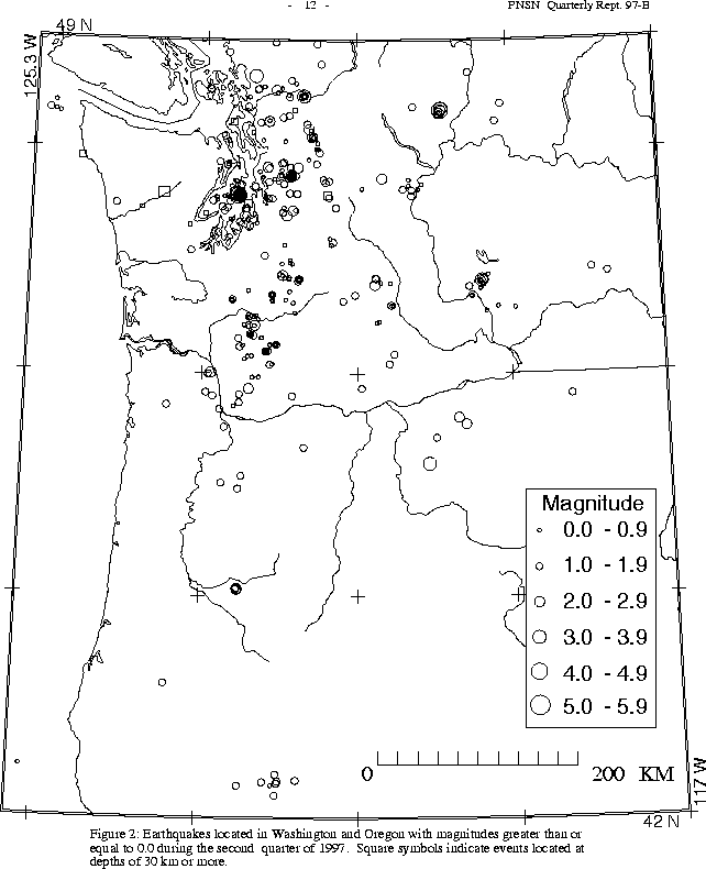
During the second quarter of 1997, 386 earthquakes were located between 45.5 degrees and 49.5 degrees north latitude and between 121 degrees and 125.3 degrees west longitude. The deepest earthquake this quarter was a magnitude 1.4 event on April 27 at 01:06 UTC at a depth of about 96 km, located about 12 km south of Skykomish. This area has long been the locus of the deepest earthquakes in the Pacific Northwest, always very small.
Twelve earthquakes were reported felt in western Washington/southwestern British Columbia this quarter (see Felt earthquakes list). Seven of these were associated with the June 23 Bremerton M 4.9 earthquake discussed above (the mainshock and six felt aftershocks before the end of June; two more Bremerton aftershocks were felt on July 11). Two felt earthquakes occurred in British Columbia beneath the Strait of Georgia; the M 4.6 mainshock on June 24, and a M 3.1 foreshock on June 13.
Several small felt earthquakes occurred this quarter, as usual. On May 3 at magnitude 2.6 earthquake was reported felt via our web-page felt-form. We received several reports from Concrete, one from Rockport, and one from Sedro Woolley. On May 18 a magnitude 3.2 earthquake near Bellingham was reported felt to Whatcom Co. emergenc y mangers, and also via our web-page felt-form (one report). A magnitude 2.6 earthquake on June 14 about 15 km south of Darrington was reported felt by a hiker near Mt. Forgotten.
Although no felt earthquakes occurred in the Duvall area this quarter, aftershocks continue (as can be seen in Fig. 2) from a magnitude 5.4 earthquake that occurred in May of 1996. Three hundred and eighty-two earthquakes were located near Duvall in the second quarter of 1996. In the third quarter of 1996 57 earthquakes were located in the area, and in the fourth quarter 25. In the first quarter of 1997 only 16 earthquakes were located near Duvall. This quarter 19 earthquakes were located near Duvall, none larger than magnitude 2.0.
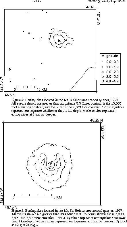
A total of 31 events (2 were smaller than magnitude 0.0, and thus are not shown in Fig. 4) were located within the region shown in Fig. 4. Of these, 11 (none smaller than magnitude 0.0; events smaller than magnitude 0.0 are not shown in Fig. 4) were located in the "Western Rainier Seismic Zone" (WRSZ), a north-south trending lineation of seismicity approximately 15 km west of the summit of Mt. Rainier (for counting purposes, the western zone is defined as 46.6-47 degrees N latitude, 121.83-122 degrees W longitude). Closer to the summit (within 5 km), there were 10 tectonic-style earthquakes. Only one event flagged "L" or "S" events was recorded this quarter. (Types L and S are not shown in Fig.4 in any case.) The remaining events were scattered around the cone of Rainier as seen in Fig. 4.
During the second quarter of 1997, 67 earthquakes were located in eastern Washington. The two largest earthquakes in the area were the June 24 Okanogan events discussed above. (see Felt earthquakes list and Okanogan earthquake, M4.6). Both of these earthquakes, magnitudes 4.6 and 3.6, were reported felt.