Information contained in this report is preliminary,
and should not be cited for publication.
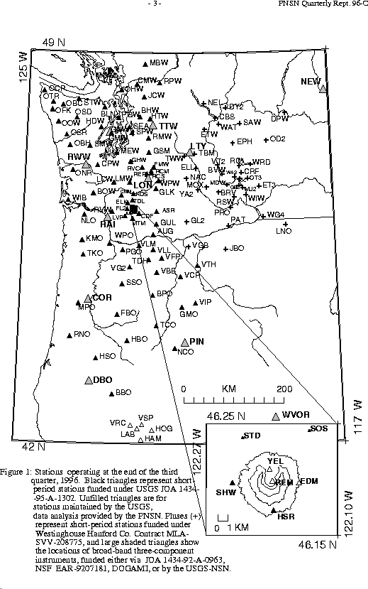
Seismograph network operation in Washington and Oregon is supported
by the state of Washington and the following contracts:
U.S. Geological Survey Joint Operating Agreement 1434-95-A-1302
and Westinghouse Hanford Company Contract MLA-SVV-208775
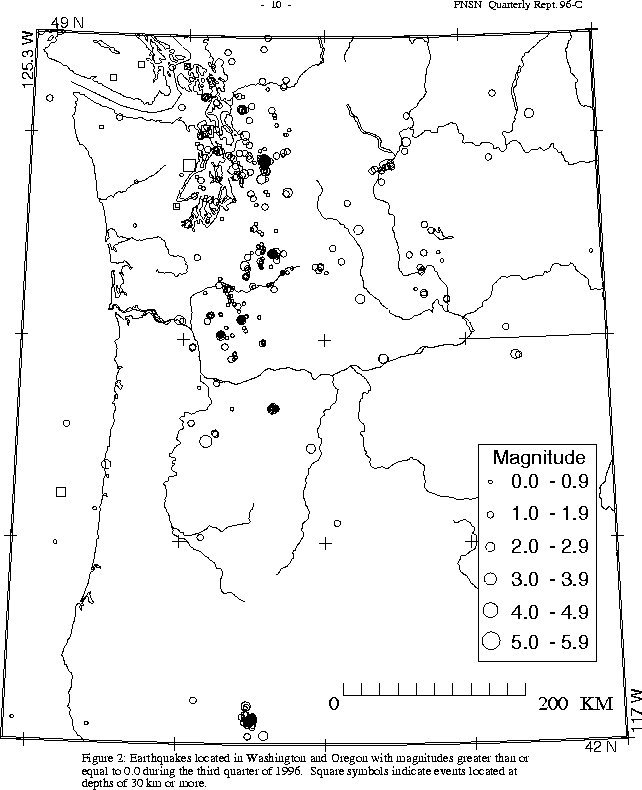
Figure 2 (16.5K). shows seismicity in Washington and Oregon during the third quarter
During the third quarter of 1996 a total of 67 earthquakes were located in Oregon between 42.0 and 45.5 degrees north latitude, and between 117 and 125 degrees west longitude. Thirty-three of these were located in the Klamath Falls area, where a pair of damaging earthquakes in September 1993 (Sept. 21, 03:29 and 05:45 UTC; magnitudes 5.9 and 6.0 respectively) were followed by a vigorous aftershock sequence which has decreased over time. This quarter, 11 earthquakes of magnitude 1.6 or larger were located in the Klamath Falls area.
Only one earthquake was reported felt in Oregon this quarter. A magnitude 3.3 earthquake on August 2 at 11:46 UTC was located at a depth of about 27 km. Although it was felt by only a few people, this event was within a few km of the epicenter of the March 1993 magnitude 5.6 Scotts Mills earthquake, and is the largest aftershock to occur in the the immediate vicinity of the mainshock since June 1993.
In Figure 2 (16.5K), a cluster of activity is visible in northern Oregon at Mt. Hood. There were two small earthquake swarms, one in July starting with a single located event on July 16th and following with six located events on July 22. The two largest events were magnitude 2.0, and depths ranged from 2 to 6 km. The second swarm was observed between Sept. 6 and 17, with a total of six located events, none larger than magnitude 1.1, and with depths around 6 km.
During the third quarter of 1996, 426 earthquakes were located between 45.5 and 49.5 degrees north latitude and between 121 and 125.3 degrees west longitude. The deepest earthquake this quarter was also one of the largest, M 3.5, at a depth of about 56 km , on Sept. 29 at 23:06 UTC). It was located about 36 km north of Poulsbo, and was reported felt.
Six earthquakes were reported felt in western Washington this quarter. The largest were two events, both magnitude 3.5, on the eastern edge of the Olympic Peninsula. These occurred on Sept. 24 at 12:45 UTC, and Sept. 29 at 23:07 UTC at depths of 47 and 56 km respectively. The first was felt in Bremerton, and the second on the west side of Whidbey Island, and as far away as downtown Vancouver, B.C. The remaining felt events this quarter included two shallow (depths <10 km) earthquakes in the Duvall area; magnitudes 3.2 (July 3, 22:04 UTC), and 2.5 (July 12 00:17 UTC); a magnitude 2.3 event felt in North Bend (August 5, 06:08 UTC, depth about 12 km) and a magnitude 2.6 earthquake near Alden (August 20, 23:55 UTC, depth about 18 km).
In the Duvall area, activity this quarter included 57 earthquakes. Last quarter 382 were located in the same area following a magnitude 5.4 earthquake at O4:04 May 3 (UTC). The largest earthquake in the Duvall vicinity this quarter was the magnitude 3.2 event discussed above.
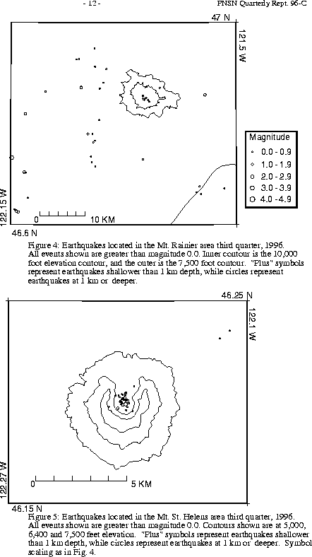
- Figures 4 and 5 (11K) show earthquakes near Mount Rainier and Mount Saint Helens. The number of events in close proximity to the cone of Mt. Rainier varies over the course of the year, since the source of much of the shallow surface-type activity is presumably ice movement or avalanching, which is seasonal in nature. Events with very low frequency signals (1-3 Hz) believed to be icequakes are assigned type "L" in the catalog. Emergent, very long duration signals probably due to rockfalls or avalanches are assigned type "S" (see Key to Earthquake Catalog). "L" and "S" type events are not shown in Figure 4.
A total of 75 events (21 of them smaller than magnitude 0., and thus not shown in Fig. 4) were located within the region shown in Fig. 4. Of these, 19 were located in the "Western Rainier Seismic Zone" (WRSZ), a north-south trending lineation of seismicity approximately 15 km west of the summit of Mt. Rainier (for counting purposes, the western zone is defined as 46.6-47 degrees N latitude, 121.83-122 degrees W longitude). Closer to the summit (within 5 km), there were 30 tectonic-style earthquakes, and 6 "L" or "S" events were located this quarter (types L and S are not shown in Fig.4). The remaining events were scattered around the cone of Rainier as seen in Fig. 4.
- Figure 2 (16.5K). shows a prominent alignment of epicenters striking NW through the Mount St. Helens area. This activity roughly delineates the St. Helens seismic zone (SHZ), a well-known 90 km long zone of seismic activity (Weaver and Smith, 1983, Jour. Geophys. Res., Vol. 88, No. B12, pp. 10,371-10, 383) which has generated several magnitude 5+ earthquakes in the last 50 years Although seismicity on the SHZ looks very prominent on Fig. 2, in fact activity this quarter (19 events excluding the activity at Mount St Helens shown in LI>Fig. 5 (11K) ) is about average (11-36 events per quarter since 1990). Although distributed along the entire length of the SHZ, this quarter's events are all very small, the largest only magnitude 1.4.
- Figure 5 (11K) shows tectonic earthquakes near Mount St. Helens. Low frequency (L) and avalanche or rockfall events (S) are not shown. In the third quarter, 83 events (only 33 magnitude 0. or larger), were located at Mt. St. Helens in the area shown in Fig. 5. This quarter, no type "S" or "L" events were located. Of this quarter's earthquakes, 35 (14 of them larger than magnitude 0.) were deeper than 4 km. The largest event at Mount St. Helens, magnitude 2.4, (September 21 at 06:26 UTC) was at a depth of about km.
During the third quarter of 1996, 48 earthquakes were located in eastern Washington. None were reported felt. The largest quake in eastern Washington this quarter was on July 29 at 11:02 UTC. It was magnitude 2.5 and was located at a depth of approximately 11 km near Ellensburg.