Information contained in this report is preliminary,
and should not be cited for publication.
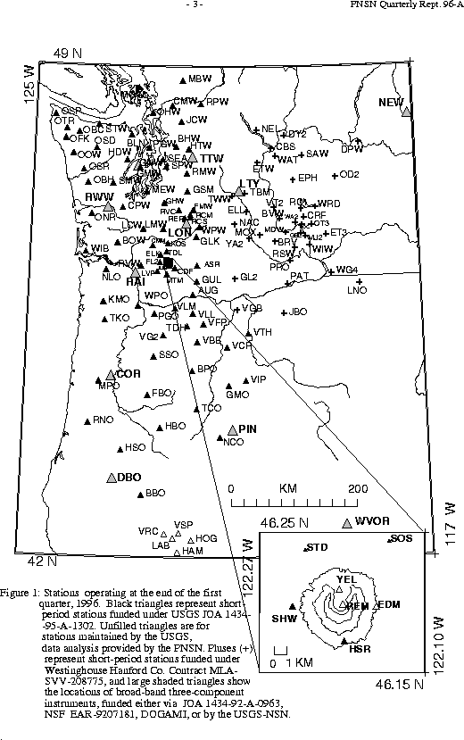
Seismograph network operation in Washington and Oregon is supported by the state of Washington and the following contracts: U.S. Geological Survey Joint Operating Agreement 1434-95-A-1302 and Westinghouse Hanford Company Contract MLA-SVV-208775
The PNSN operates seismograph stations in Washington and Oregon.
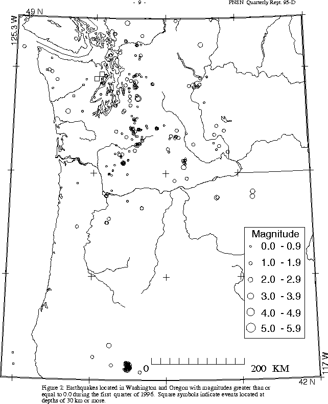
Figure 2 shows seismicity in Washington and Oregon during the first quarter
During the first quarter of 1996, no earthquakes were reported felt in Oregon. A total of 75 earthquakes were located in Oregon between 42.0 and 45.5 degrees north latitude, and between 117 and 125 degrees west longitude. All but 7 of these were located in the Klamath Falls area, where a pair of damaging earthquakes in September of 1993 (Sept. 21, 03:29 and 05:45 UTC; magnitudes 5.9 and 6.0 respectively) were followed by a vigorous aftershock sequence which has decreased over time. This quarter, 15 earthquakes of magnitude 1.6 or larger were located in the Klamath Falls area. The largest Oregon earthquake this quarter was magnitude 2.3 and occurred at about 10 km depth near Klamath Falls on Feb. 13 at 20:05 UTC
During the first quarter of 1996, 302 earthquakes were located between 45.5-49.5 degrees north latitude and between 121 and 125.3 degrees west longitude.The deepest earthquake this quarter (M 2.0, depth about 48 km, on Jan 23 at 05:21 UTC) occurred near Poulsbo. Two earthquakes were reported felt in western Washington during the first quarter of 1996, both on January 21 when two earthquakes, magnitudes 3.3 and 2.8, at around 21 km depth were located about 5 km south of North Bend. The larger event (at 16:06 UTC) was widely felt in King County, while the smaller event (19:1 UTC) was felt by some people in North Bend, Crystal Mountain, and as far away as Fife.
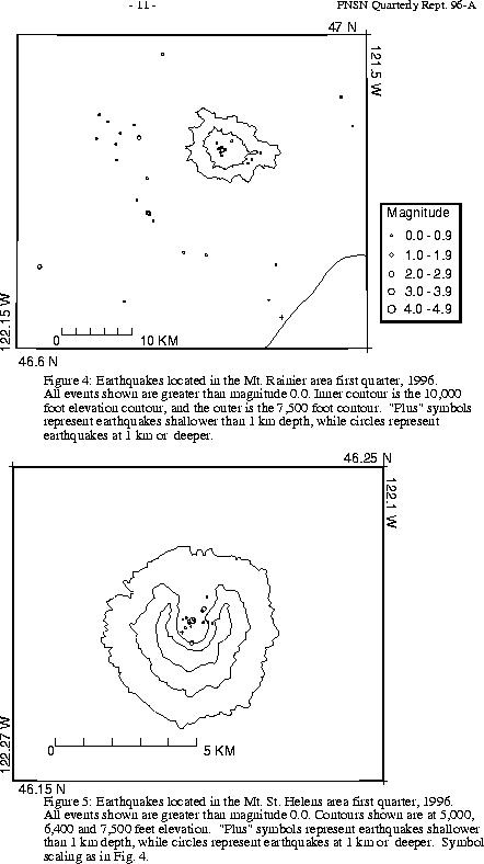
A total of 56 events (19 of them smaller than magnitude 0., and thus not shown in the figure) were located within the region shown in Fig. 4. Of these, 21 were located in the "Western Rainier Seismic Zone" (WRSZ), a north-south trending lineation of seismicity approximately 15 km west of the summit of Mt. Rainier (for counting purposes, the western zone is defined as 46.6-47 degrees N latitude, 121.83-122 degrees W longitude). Closer to the summit (within 5 km), there were 20 earthquakes, but no type "L" or "S" events this quarter (types L and S are not shown in Fig.4). The remaining events were scattered around the cone of Rainier as seen in Fig. 4.
During the first quarter of 1996, 54 earthquakes were located in eastern Washington. The two largest quakes this quarter were both magnitude 2.9, and neither one was reported felt. The first, on February 13, at 12:48 UTC, and was located 65 km west south-west of Pendleton, Oregon, at a shallow depth of only a few km. It was followed by a nearby earthquake, magnitude 2.6, also shallow, on Feb. 14 at 19:53.
The other magnitude 2.9 earthquake east of the Cascades this quarter occurred in the Okanogan National Forest in the North Cascades. It was on February 24 at 03:51 UTC (at a very shallow depth) at a location about 34 km WNW of the town of Okanogan, near Beaver Ridge.