Information contained in this report is preliminary,
and should not be cited for publication.
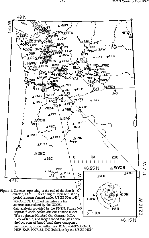
Seismograph network operation in Washington and Oregon is supported by the state of Washington and the following contracts: U.S. Geological Survey Joint Operating Agreement 1434-95-A-1302 and Westinghouse Hanford Company Contract MLA-SVV-208775
The PNSN operates seismograph stations in Washington and Oregon.
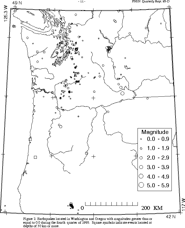
Figure 2 shows seismicity in Washington and Oregon during the fourth quarter
During the fourth quarter of 1995, no earthquakes were reported felt in Oregon. A total of 82 earthquakes were located in Oregon between 42.0-45.5 degrees north latitude, and 117-125 degrees west longitude. All but 11 of these were located in the Klamath Falls area, where a pair of damaging earthquakes in September of 1993 (Sept. 21, 03:29 and 05:45 UTC; @ M sub c @ 5.9 and 6.0 respectively) were followed by a vigorous aftershock sequence which has decreased over time. This quarter, only two earthquakes of magnitude 1.6 or larger were located in the Klamath Falls area.
During the fourth quarter of 1995, 484 earthquakes were located between 45.5-49.5 degrees north latitude and between
121 and 125.3 degrees west longitude. The deepest earthquake this quarter (M 0.9, depth approximately 92 km, on December 27 at 04:18 UTC) occurred near Hyak, in the Cascades southeast of Seattle. Hyak is the consistent locus of the deepest events within our network. No earthquakes were reported felt in western Washington during the fourth quarter of 1995. The largest western Washington earthquake during the quarter was a magnitude 2.6 earthquake at a depth of about 16 km near the town of Carnation on Oct. 25 at 01:11 UTC.
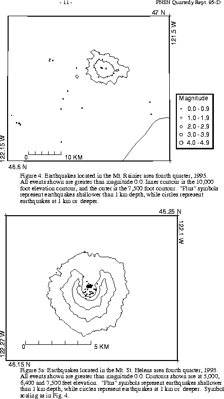
A total of 41 events (21 of them smaller than magnitude 0.) were located within the region shown in Fig. 4. Of these, 18 were located in the "Western Rainier Seismic Zone" (WRSZ), a north-south trending lineation of seismicity approximately 15 km west of the summit of Mt. Rainier (for counting purposes, the western zone is defined as 46.6-47 degrees N latitude, 121.83-122 degrees W longitude). Closer to the summit (within 5 km), there were 12 earthquakes, but no type "L" or "S" events this quarter (types L and S are not shown in Fig.4). The remaining events were scattered around the cone of Rainier as seen in Fig. 4.
Last quarter, seismic activity at Mount St. Helens was at a slightly elevated level, which reached a peak in the month of October before decreasing toward a more typical background level. During 1995, the numbers of events per month were 5, 2, 11, 2 7, 16, 61, 75, 115, 128, 153, 69, and 42. Monthly earthquake counts in 1994 ranged from 6 to 34. Of the 153 events in October, 117 were deeper than 4 km, but the largest of the deep events was only magnitude 1.2; and only four events during October were larger than magnitude 1.0. This quarter, the largest St. Helens eve nt was
magnitude 1.8 (Nov. 16).
During the fourth quarter of 1995, 50 earthquakes were located in eastern Washington. One quake, magnitude 3.1, was reported felt. It occurred on December 17, at 15:01 UTC, and was located 7 km S of Entiat with a depth of 12 km. Radio stations in the area received a few calls from people who felt the event. Another magnitude 3.1 earthquake on November 2 at 14:30 UTC, was located 17.0 km ESE of Prosser at a depth of 21 km, but was not reported felt.