Information contained in this report is preliminary,
and should not be cited for publication. The on-line version of the quarterly isabbreviated. The complete quarterly is available in paper version on request.
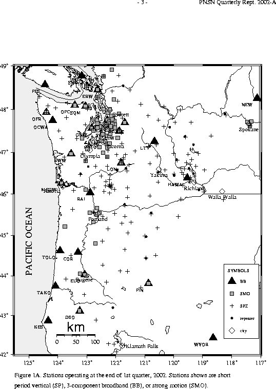
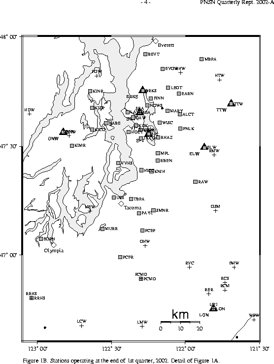
Seismograph network operation in Washington and Oregon is supported by the state of Washington and the following contracts: U.S. Geological Survey Joint Operating Agreement 01-HQ-AG-0011 and Contract 259116-A-B3 from the Pacific Northwest National Laboratory, operated by Battelle for the U.S. Dept. of Energy
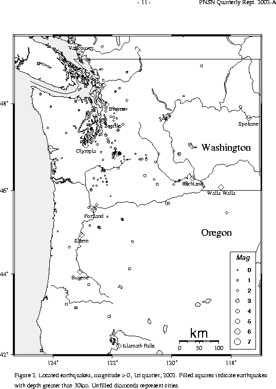
There were 740 events digitally recorded and processed at the University of Washington between January 1 and March 31, 2002. Locations in Washington, Oregon, or southernmost British Columbia were determined for 368 of these events; 294 were classified as earthquakes and 74 as known or suspected blasts. The remaining 372 processed events include teleseisms (144 events), regional events outside the PNSN (59), and unlocated events within the PNSN. Unlocated events within the PNSN include very small earthquakes and some known blasts. Frequent mining blasts occur near Centralia, Washington and we routinely locate some of them.
Table 3A is a listing of all earthquakes reported to have been felt during
this quarter, events for which
ShakeMaps or Community Internet Intensity Maps (CIIM) are noted.
ShakeMap shows instrumentally measured shaking.
CIIM maps are made using "felt" reports relayed via Internet. These "felt" reports are converted into numeric intensity values, and the CIIM map shows the average intensity by zip code.
TABLE 3A: EARTHQUAKES REPORTED FELT, 1st QUARTER, 2002
    DATE-(UTC)-TIME	LAT(N)	LON(W)	DEPTH	MAG	COMMENTS			CIIM	 SHAKEMAP
  yy/mm/dd hh:mm:ss   deg.   deg.    km

02/01/04 07:16:12   47.67   117.41     0.6   -0.7       0.7 km WNW of Spokane, WA
02/01/09 03:26:54   48.11   123.12    21.8    2.9      23.4 km   E of Port Angeles, WA   x
02/01/26 14:01:46   47.13   122.13     8.5    2.4      13.7 km  SW of Enumclaw, WA
02/02/12 19:16:41   48.41   122.28    18.6    3.0       4.0 km   E of Mount Vernon, WA   x   x
02/03/11 00:43:51   47.50   122.73    22.7    1.7      10.6 km  SW of Bremerton, WA
During the first quarter of 2002, a total of 37 earthquakes were located in Oregon
between 42.0° and 45.5° north latitude, and between
117° and 125° west longitude.
A detailed study of Mt. Hood seismicity is underway and will be reported on in a later quarterly.
In the Klamath Falls area, 18 earthquakes occurred in the first quarter of 2002. Since 1994, most earthquakes in the Klamath Falls area have been considered aftershocks or earthquake activity related to a pair of damaging earthquakes in September, 1993. The 1993 earthquakes were followed by a vigorous aftershock sequence which decreased over time.
During the first quarter of 2002, 219 earthquakes were located between 45.5° and 49.5° north latitude and between 121° and 125.3° west longitude. Four earthquakes were felt this quarter in western Washington. Details are in Table 3A.
The largest felt earthquake in western Washington was a magnitude 3.0 earthquake about 4 km east of Mount Vernon. It located at a depth of about 19 km. The deepest quake in westen Washington was a magnitude 1.0 earthquake at about 54 km, located about 42 km north-northwest of Poulsbo, WA.
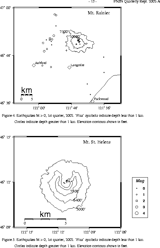
The number of events in close proximity to the cone of Mt. Rainier varies over the course of the year, since the source of much of the shallow activity is presumably ice movement or avalanching at the surface, which is seasonal in nature. Events with very low frequency signals (1-3 Hz) believed to be icequakes are assigned type "L" in the catalog. Emergent, very long duration signals, probably due to rockfalls or avalanches, are assigned type "S" (see Key to Earthquake Catalog). There were no events flagged "L" or "S" were located at Mount Rainier this quarter but 9 "L" or "S" events were recorded, but were too small to locate reliably. Type L and S events are not shown in Fig. 4.
A total of 49 tectonic events (14 of these were smaller than magnitude 0.0, and
thus are
not shown in Fig. 4) were located within the region shown in Fig. 4.
The largest tectonic earthquake located near Mt. Rainier this quarter was a magnitude 3.2 earthquake on February 19 at 18:42 UTC, located about 0.8 km north-east of the summit at a very shallow depth (<1km). This quarter, 27 of the tectonic earthquakes were located in the "Western Rainier Seismic Zone" (WRSZ), a north-south trending lineation of seismicity approximately 15 km west of the summit of Mt. Rainier (for counting purposes, the western zone is defined as 46.6-47 degrees north latitude and 121.83-122 west longitude). Within 5 km of the summit, there were 16 (3 of them smaller than magnitude 0.0 and thus not shown in Fig. 4) higher-frequency tectonic-style earthquakes, and the remaining events were scattered around the cone of Rainier as seen in Fig. 4.
This quarter, 44 earthquakes were located at Mount St. Helens in the area shown in Fig. 5. Of these earthquakes, 11 were magnitude 0.0 or larger and 5 were deeper than 4 km. The largest tectonic earthquake at Mount St. Helens this quarter was a magnitude 1.1 event on January 16 UTC located 0.5 km N of Mount St. Helens at about 2 km depth.
No type "S" or "L" events were located at Mount St. Helens, and 15 "L" or "S" events too small to locate were recorded.
During the first quarter of 2002, 38 earthquakes were located in eastern Washington in the area between 45.5-49.5 degrees north latitude and 117-121 degrees west longitude. Activity in the Spokane area, discussed at length in the last two quarterlies, was quiet in the first quarter of 2002. Only one very small (M -0.7), but felt, quake was located in downtown Spokane. The largest earthquake in eastern Washington this quarter was magnitude 2.9. It had a depth of about 2 km, and was located 22 km east-southeast of Vantage.