Information contained in this report is preliminary,
and should not be cited for publication. The on-line version of the quarterly isabbreviated. The complete quarterly is available in paper version on request.
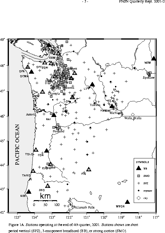
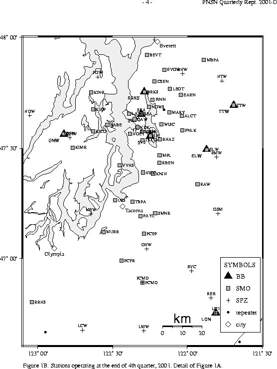
Seismograph network operation in Washington and Oregon is supported by the state of Washington and the following contracts: U.S. Geological Survey Joint Operating Agreement 01-HQ-AG-0011 and Contract 259116-A-B3 from the Pacific Northwest National Laboratory, operated by Battelle for the U.S. Dept. of Energy
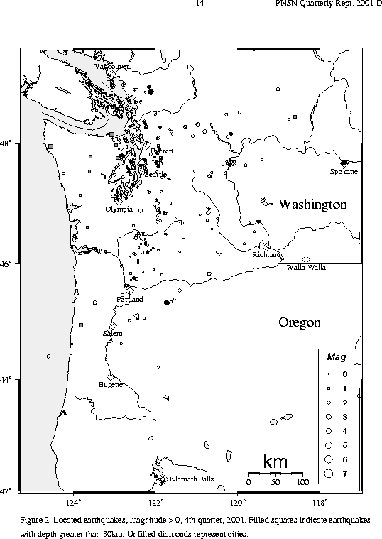
There were 1,138 events digitally recorded and processed at the University of Washington between October 1 and December 31, 2001. Locations in Washington, Oregon, or southernmost British Columbia were determined for 575 of these events; 502 were classified as earthquakes and 73 as known or suspected blasts. The remaining 563 processed events include teleseisms (138 events), regional events outside the PNSN (62), and unlocated events within the PNSN. Unlocated events within the PNSN include very small earthquakes and some known blasts. Frequent mining blasts occur near Centralia, Washington and we routinely locate some of them.
Table 3A is a listing of all earthquakes reported to have been felt during
this quarter, events for which
ShakeMaps or Community Internet Intensity Maps (CIIM) are noted.
ShakeMap shows instrumentally measured shaking.
CIIM maps are made using "felt" reports relayed via Internet. These "felt" reports are converted into numeric intensity values, and the CIIM map shows the average intensity by zip code.
TABLE 3A: EARTHQUAKES REPORTED FELT, 4th QUARTER, 2001
    DATE-(UTC)-TIME	LAT(N)	LON(W)	DEPTH	MAG	COMMENTS			CIIM	 SHAKEMAP
  yy/mm/dd hh:mm:ss   deg.   deg.    km

01/10/05 02:26:41	48.82N	122.11W	 12.1	 3.0 	  7.6 km   E of Deming, WA	x
01/10/06 10:52:09	48.83N	122.10W	 13.2	 3.0 	  8.2 km   E of Deming, WA
01/10/15 04:57:01	48.15N	123.06W	 44.4	 2.9 	 28.6 km   E of Port Angeles, WA
01/11/10 18:30:59	48.93N	123.04W	 15.4	 3.4 	 21.7 km   S of Vancouver,BC	x
01/11/11 16:00:29	47.68N	117.40W	  4.7	 4.0 	  1.9 km   N of Spokane, WA	x
01/11/11 17:21:33	47.68N	117.40W	  0.6	 3.1 	  1.3 km   N of Spokane, WA
01/11/12 03:03:02	47.68N	117.40W	  0.6	 3.3 	  2.0 km   N of Spokane, WA	x
01/11/12 03:07:40	47.68N	117.41W	  0.6	 1.9 	  1.7 km NNW of Spokane, WA
01/11/12 03:11:15	47.68N	117.41W	  0.6	 2.4 	  2.1 km NNW of Spokane, WA
01/11/12 11:44:18	47.68N	117.39W	  0.6	 1.7 	  2.2 km NNE of Spokane, WA
01/11/12 13:25:59	47.68N	117.40W	  0.5	 1.9 	  2.0 km   N of Spokane, WA
01/11/13 05:41:45	47.69N	117.40W	  0.6	 2.3 	  2.5 km   N of Spokane, WA
01/11/13 07:39:05	47.68N	117.42W	  0.6	 2.1 	  1.7 km  NW of Spokane, WA
01/11/13 10:14:01	48.86N	122.46W	 22.0	 2.5 	 11.7 km   N of Bellingham, WA
01/11/13 20:26:26	47.69N	117.40W	  0.6	 3.0 	  2.1 km   N of Spokane, WA	x
01/11/14 01:50:51	47.69N	117.38W	  0.6	 1.2 	  3.4 km NNE of Spokane, WA
01/11/14 16:41:20	47.69N	117.32W	  0.6	 1.6 	  6.9 km ENE of Spokane, WA
01/11/15 00:11:46	47.69N	117.39W	  0.0	 2.1 	  2.5 km NNE of Spokane, WA
01/11/16 01:42:29	47.68N	117.39W	  0.5	 1.8 	  2.0 km NNE of Spokane, WA
01/11/17 16:18:49	47.68N	117.42W	  0.4	 1.4 	  2.2 km  NW of Spokane, WA
01/11/18 19:51:12	47.68N	117.42W	  0.8	 1.6 	  1.8 km  NW of Spokane, WA
01/11/19 04:47:06	47.68N	117.41W	  2.2	 1.2 	  1.7 km  NW of Spokane, WA
01/11/19 04:47:52	47.69N	117.41W	  1.2	 0.5 	  3.1 km NNW of Spokane, WA
01/11/20 06:03:56	47.67N	117.44W	  2.6	 1.0 	  2.8 km WNW of Spokane, WA
01/11/20 12:14:42	47.67N	117.44W	  0.0	 1.4 	  3.0 km   W of Spokane, WA
01/11/22 04:43:01	47.68N	117.42W	  2.5	 1.4 	  1.6 km  NW of Spokane, WA
01/11/24 00:32:10	47.67N	117.43W	  2.1	-0.5 	  2.1 km WNW of Spokane, WA
01/11/26 04:13:15	47.68N	117.42W	  2.2	 0.9 	  1.9 km  NW of Spokane, WA
01/11/26 09:41:37	47.69N	117.40W	  0.0	-0.8 	  3.0 km   N of Spokane, WA
01/11/26 09:41:53	47.68N	117.43W	  2.1	 0.0 	  2.2 km WNW of Spokane, WA
01/11/26 09:59:53	47.68N	117.38W	  4.7	-1.6 	  2.0 km  NE of Spokane, WA
01/11/26 10:12:11	47.68N	117.40W	  2.3	-1.6 	  1.7 km   N of Spokane, WA
01/11/26 11:56:07	47.68N	117.41W	  2.2	 0.7 	  1.8 km NNW of Spokane, WA
01/11/27 08:26:58	47.65N	117.44W	  0.5	-0.9 	  3.8 km WSW of Spokane, WA
01/12/06 23:24:08	46.89N	122.36W	 20.4	 2.4 	  8.1 km WNW of Eatonville, WA
01/12/19 06:39:26	47.69N	117.38W	  0.0	-0.8 	  2.8 km NNE of Spokane, WA
01/12/19 21:32:17	47.67N	117.44W	  2.0	-0.8 	  2.7 km   W of Spokane, WA
01/12/20 03:03:20	47.67N	117.44W	  2.0	-0.5 	  2.8 km   W of Spokane, WA
01/12/20 08:30:43	47.67N	117.43W	  1.8	-0.1 	  2.6 km   W of Spokane, WA
01/12/25 03:58:53	47.68N	117.42W	  0.2	-0.7 	  2.0 km WNW of Spokane, WA
01/12/27 22:11:20	47.66N	117.43W	  0.0	-0.5 	  2.4 km   W of Spokane, WA
01/12/29 11:57:27	47.67N	117.43W	  0.0	-0.8 	  2.5 km   W of Spokane, WA
A detailed study of Mt. Hood seismicity is underway and will be reported on in a later quarterly.
In the Klamath Falls area, 15 earthquakes occurred in the fourth quarter of 2001. Since 1994, most earthquakes in the Klamath Falls area have been considered aftershocks or earthquake activity related to a pair of damaging earthquakes in September, 1993. The 1993 earthquakes were followed by a vigorous aftershock sequence which decreased over time.
During the fourth quarter of 2001, 368 earthquakes were located between 45.5° and 49.5° north latitude and between 121° and 125.3° west longitude. Six earthquakes were felt this quarter in western Washington. Details are in Table 3A.
The largest felt earthquake in western Washington was a magnitude 3.4 earthquake near Point Roberts on November 10. Point Roberts, although in the United States, is isolated from the US mainland and located at the southern tip of a peninsula that originates in Canada. It is closer to Vancouver, B.C. than to Bellingham.
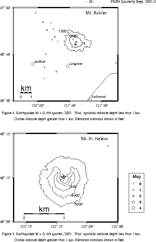
The number of events in close proximity to the cone of Mt. Rainier varies over the course of the year, since the source of much of the shallow activity is presumably ice movement or avalanching at the surface, which is seasonal in nature. Events with very low frequency signals (1-3 Hz) believed to be icequakes are assigned type "L" in the catalog. Emergent, very long duration signals, probably due to rockfalls or avalanches, are assigned type "S" (see Key to Earthquake Catalog). There were no events flagged "L" or "S" were located at Mount Rainier this quarter but 120 "L" or "S" events were recorded, but were too small to locate reliably. Type L and S events are not shown in Fig. 4.
A total of 40 tectonic events (19 of these were smaller than magnitude 0.0, and thus are
not shown in Fig. 4) were located within the region shown in Fig. 4.
The largest tectonic earthquake located near Mt. Rainier this quarter was a magnitude 1.6 earthquake on November 16 UTC, located about 15 km west-north-west of the summit at a depth of about 12 km. This quarter, 23 of the tectonic earthquakes were located in the "Western Rainier Seismic Zone" (WRSZ), a north-south trending
lineation of seismicity approximately 15 km west of the summit of Mt. Rainier (for counting purposes, the western zone is defined as 46.6-47 degrees north latitude and 121.83-122 west longitude).
Within 5 km of the summit, there were 13 (7 of them smaller than magnitude 0.0 and thus not shown in Fig. 4) higher-frequency tectonic-style earthquakes, and
the remaining events were scattered around the cone of Rainier as seen in
Fig. 4.
Beginning on November 3, 2001 a vigorous sequence of very small earthquakes was
recorded on stations on Mount St. Helens. An information statement:
http://vulcan.wr.usgs.gov/Volcanoes/Cascades/CurrentActivity/2001/current_updates_20011103.html
was issued by the USGS Cascades Volcano Observatory. These events were located inside the crater of Mt. St. Helens within the dome of hardened lava that has been
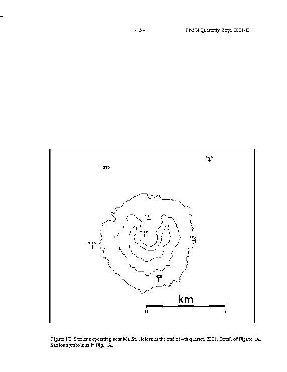
extruded since the catastrophic eruption of May 18, 1980. Station SEP is located on the dome (see Fig. 1C), and recorded about 3,800 tiny events during the first
week of November. However almost all of the events in this swarm were very small. Their signals were not well recorded outside the crater, and precise locations were impossible.
A web page with links to webicorder records, spectrograms, and other information is at:
http://spike.ess.washington.edu/SEIS/PNSN/WEBICORDER/HELENS/
This quarter, 126 earthquakes were located at Mount St. Helens in the area shown in Fig. 5. Of these earthquakes, 18 were magnitude 0.0 or larger and 4 were deeper than 4 km. The largest tectonic earthquake at Mount St. Helens this quarter was a magnitude 1.7 event on Oct. 26 UTC located .4 km NE of Mount St. Helens.
One type "S" or "L" events was located at Mount St. Helens, and 52 "L" or "S" events too small to locate were recorded.
During the fourth quarter of 2001, 88 earthquakes were located in eastern Washington in the area between 45.5-49.5 degrees north latitude and 117-121 degrees west longitude.
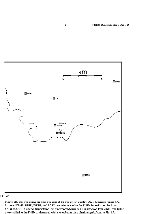
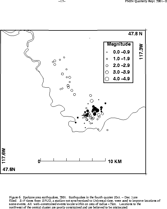
The most unusual activity in eastern Washington this quarter was the continuation of a very unusual sequence of earthquakes in the Spokane urban area.
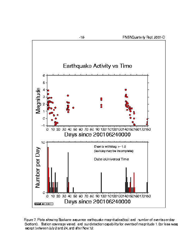
Spokane is an area that historically has been seismically quiet, and is located at the very edge of the seismograph network operated by the Pacific Northwest Seismograph Network (PNSN). The extended, intermittent sequence of 2001 is unprecedented in the 150 year written history of the area. This very shallow crustal sequence is occurring immediately beneath urban Spokane, a city with many unreinforced masonry buildings. In addition, incredibly tiny earthquakes (magnitudes as small as -1.7) are being reported felt and/or heard. This appears to be due to the extreme shallowness of the events and the high population density. Figure 6 shows a map view of earthquakes in 2001 located near Spokane. Fourth-quarter earthquakes are shown as filled symbols. Figure 7 shows the magnitude distribution vs time (top), and the number of events per day vs time (bottom).
On the morning of June 25 (at 7:15 and 8:01 AM PDT), two earthquakes, M 3.9 and M 3.4 were widely felt in urban Spokane. Additional smaller events continued and twenty-three other events were located during the following week. A foreshock on May 24 of M 2.0 was also felt. At the beginning of July activity dropped off for several weeks.
Another spurt of activity began in late July. Fourteen events were located between July 29 and August 1. The largest event in this time period was magnitude 3.2. Following August 1, seismicity quieted for about 8 weeks.
In late September seismicity picked up again when four events occurred within a ten-minute period on Sept. 28. The largest was a magnitude 2.8 that was noticed by many people in the downtown area, as was the magnitude 2.6 that followed about 4 minutes later. The September events were followed by a quiet period lasting about 6 weeks.
On November 11, activity resumed with a magnitude 4.0 earthquake, the largest in the sequence so far. Additional earthquakes followed, and a total of 36 earthquakes were located in Spokane during the fourth quarter. Out of the total of 36, 35 were reported felt, including events as small as -1.6.
During the fits and starts of activity in the Spokane sequence, various seismic recording equipment was operated: