Information contained in this report is preliminary,
and should not be cited for publication.
Seismograph network operation in Washington and Oregon is supported by the state of Washington and the following contracts: U.S. Geological Survey Joint Operating Agreement 1434-HQ-98-AG-01937 and Contract 259116-A-B3 from the Pacific Northwest National Laboratory, operated by Battelle for the U.S. Dept. of Energy
  DATE-(UTC)-TIME   LAT(N) LON(W)  DEPTH   MAG  COMMENTS
  yy/mm/dd hh:mm:ss   deg.   deg.    km

00/09/10 14:53:38    48.42N 123.19W  49.3   3.2  BC  11.6 km   E of Victoria, BC
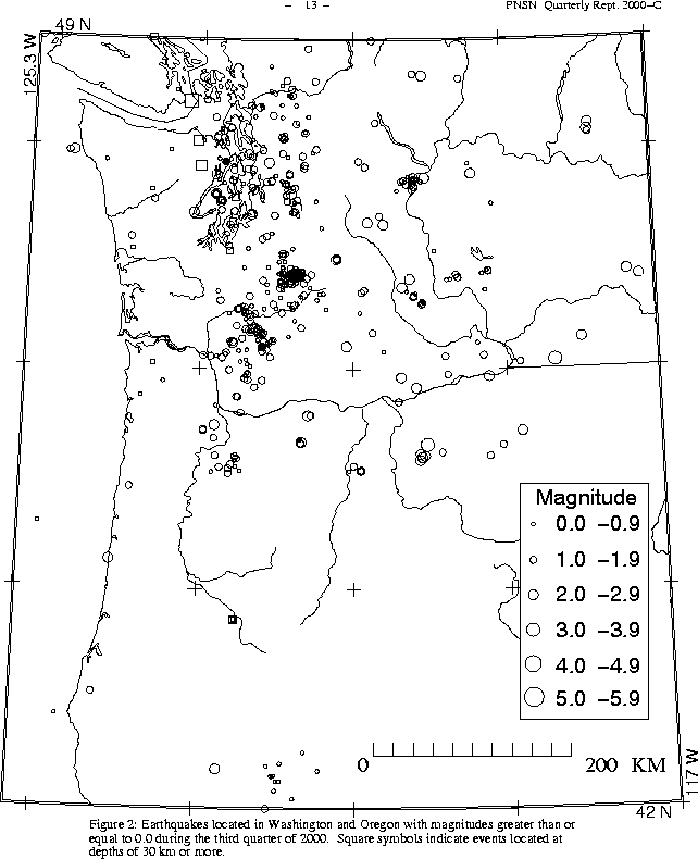
There were 2,031 events digitally recorded and processed at the University of Washington between July 1 and September 30, 2000. Locations in Washington, Oregon, or southernmost British Columbia were determined for 939 of these events; 843 were classified as earthquakes and 96 as known or suspected blasts. The remaining 1,092 processed events include teleseisms (271 events), regional events outside the PNSN (53), and unlocated events within the PNSN. Unlocated events within the PNSN include very small earthquakes and some known blasts. Frequent mining blasts occur near Centralia, Washington and we routinely locate and retrieve broad-band data for some of them.
The most interesting activity in Oregon thi s quarter were 5 events that occurred on August 14 about 59 km SE of Eugene. All were very close together, and all located at about 43 km, a very unusual dep th for this part of Oregon -- much deeper than typical Oregon crustal earthquakes. Other interesting Oregon activity this quarter included five events larger than magnitude 2 that occurred 10 km or so east of Condon; the lar gest was magnitude 3.2 on 8/17 at 01:58 UTC. In eastern Oregon, within 50 km of Baker, two events larger than magnitude 3. were recorded; on 7/13 at 22:30 UTC and on 8/27 at 21:20 UTC. No events were reported felt in Oregon this quarter.
In the Klamath Falls area, 14 earthquakes were located this quarter. Since 1994, most earthquakes northwest of Klamath Falls have been considered aftershocks of a pair of damaging earthquakes in September of \fI1993\fR (Sept. 21, 03:29 and 05:45 UTC; Mc 5.9 and 6.0 respectively). The 1993 earthquakes were followed by a vigorous aftershock sequence which decreased over time.
During the third quarter of 2000, 669 earthquakes were located between 45.5°-49.5° north latitude and 121°-125.3° west longitude.
One earthquake was felt this quarter in western Washington. That earthquake, on September 10, was actually located in British Columbia, but was felt in Washingt on in Friday Harbor, and the San Juan Islands, in Port Townsend, Bellingham, Sta nwood and as far as Anacortes. Details are given in Table 3. This event, at abo ut 49 km, was also the deepest quake this quarter.
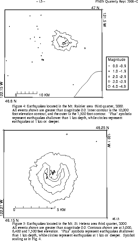
The repair of summit station RSU had a big effect on the event counts at Mount R ainier this quarter. The summit station provided data that allowed much smaller events near the summit (mostly shallow low frequency events) to be locat ed. Because of RSU, 215 events flagged "L" or "S" events were located at Mount Rainier this quarter and an additional 334 "L" or "S" events were recorded, but were too small to locate reliably. Without RSU most of these events would have simply failed to trigger our system. The change in event count s is due simply to the operation of RSU.
A total of 51 tectonic events (18 of these were smaller than magnitude 0.0, and thus are not shown in Fig. 4) were located within the region shown in Fig. 4. Of these, 28 were located in the "Western Rainier Seismic Zone" (WRSZ), a north-south trending lineation of seismicity approximately 15 km west of the summit of Mt. Rainier (for counting purposes, the western zone is defined as 46.6-47 degrees north latitude and 121.83-122 west longitude). tectonic earthquakes larger than magnitude 1.8 were located near Mt. Rainier this quarter.
This quarter, there were 14 higher-frequency tectonic-style earthquake within 5 km of the summit. The remaining events were scattered around the cone of Rainier as seen in Fig. 4.
Eight type "S" or "L" event were located at Mount St. Helens, and 363 "L" or "S" events too small to locate were recorded.
During the third quarter of 2000, 82 earthquakes were located in eastern Washington. The largest earthquake in eastern Washington this quarter was a very shallow (location less than 1 km deep) magnit ude 3.0 earthquake about 3 km west north-west of Walla Walla.
Times, locations, and depths of felt earthquakes in the PNSN region are given in Table 3.